
Ministry of Transportation and Infrastructure personnel are working to scale and blast the rockfall which occurred on Highway 97 north of Summerland over the weekend. The ministry says it hopes to have the road opened tomorrow, Feb. 6, 2019.
Image Credit: SUBMITTED/ Ministry of Tranportation
February 05, 2019 - 3:00 PM
PENTICTON - A $54 million highway widening project north of Summerland seems to have opened a Pandora’s box of potential rockslide issues since its completion in late 2008.
At least three major rockslides have come down on the four-lane section of Highway 97 between Summerland and Peachland since the last road widening project began along that stretch of highway, and according to professional engineer Dr. Dwayne Tannant, there is a strong likelihood this particular stretch will continue to have problems in the future, due to some unique local geology.
Tannant, who has a PhD in civil engineering and a Bachelor of Science in geological engineering, studied the issue after the first slide occurred in late October, 2008 and published a University of British Columbia report on geohazards in the South Okanagan as a result. His current research involves study of rock mechanics, geotechnical engineering and engineering geology.
The first event, dubbed the Goat Bluff Rockslide, closed the highway for 18 days between Oct. 22 and Nov. 12, 2008, after a 10 centimetre fracture was discovered in a rock face above the highway.
Tannant noted in his study, rock was blasted for 12 days and after an additional $6,000,000 was spent in blasting and remediation work, the road was reopened again.
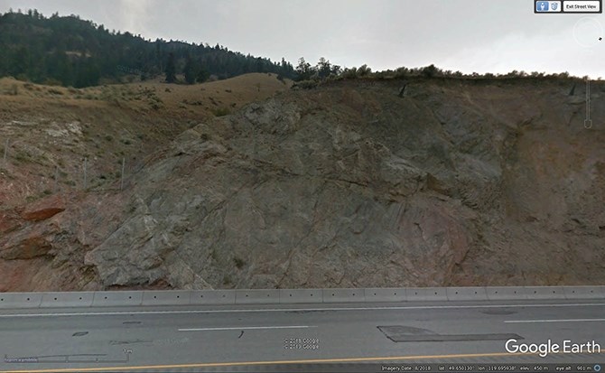
Dr. Dwayne Tannant says this photo shows the failure area in the mountainside above Highway 97 north of Summerland, noting visible geological structures he believes contributed to the slide.
Image Credit: Google Earth
On Sunday, July 6, 2014, a second rockslide occurred along the same stretch of roadway, this time injuring two people and shutting down the southbound lanes for several hours.
The rockslide on Thursday, Jan. 31, didn’t completely shut down the highway until a much bigger slide took place on Saturday, Feb. 2. Tannant says it appears the latest slide occurred in almost exactly the same location as the one that took place in July, 2014.
“It’s not surprising there’s a problem in that area. The rock face contains geological structures the rocks are sliding on,” he said, describing the geology as “small shear zones with a weak mineral coating on them, oriented in such a way they slope down towards the road.”
Tannant said the whole mass is sliding on a single surface which is weak to begin with and getting weaker with time.
He said this winter’s freeze-thaw cycle might have had some effect, but he believes the main issue is the creation of ice dams from water trying to seep out of the slope. Pressure builds on the shear plane and the extra water pressure triggers the slide.
Tannant said there should be some concern over the possibility of more and larger slides in the future, noting other geological structures to the north that could contribute to another area of sliding, possibly even bigger than what came down last week.
Tannant said its tough to flatten the slope along this section of roadway because “you’re chasing the whole mountainside.”
Last week’s slide happened on relatively small outcrop of rock compared to other rocks faces along that stretch.
Tannant said its only since the road widening project took place these events have occurred, because the road widening effort exposed the problematic rock faces in this area, in addition to cutting into the mountain and undercutting the pre-existing geological structures that slope towards Okanagan Lake.
Tannant noted the road widening project included extensive rock scaling, slope stabilization and rockfall containment initiatives, including well-designed ditches designed to contain large rocks, but none of that was meant to contain what came down last week.
Ministry of Transportation and Infrastructure spokesperson Danielle Pope said today, Feb. 5, the ministry hopes to have the highway open tomorrow after blasting approximately 100 cubic metres of rock.
Ten rock scalers continue to prepare the slope for further blasting, supported by two excavators, a rock hammer and off-highway rock trucks supplied by Argo Maintenance.
Pope said geotechnical engineers will re-assess the slope today to determine next steps.
To contact a reporter for this story, email Steve Arstad or call 250-488-3065 or email the editor. You can also submit photos, videos or news tips to the newsroom and be entered to win a monthly prize draw.
We welcome your comments and opinions on our stories but play nice. We won't censor or delete comments unless they contain off-topic statements or links, unnecessary vulgarity, false facts, spam or obviously fake profiles. If you have any concerns about what you see in comments, email the editor in the link above.
News from © iNFOnews, 2019