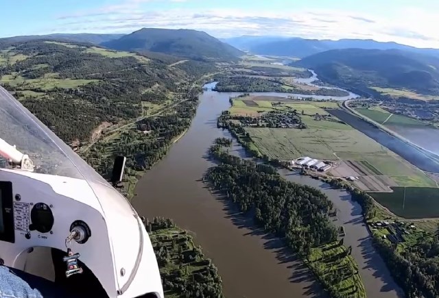
Jan Nademlejnsky flew over the North Thompson River on June 11, 2022, filming views of the river as it approaches its peak for this season.
Image Credit: YOUTUBE/Jan Nademlejnsky
June 14, 2022 - 7:00 PM
A Kamloops pilot has provided a bird's eye view of the rising North and South Thompson rivers.
As the North Thompson River approaches its peak for the season, Kamloops residents are preparing for potential floods. The late-season melt means it's still likely one week from its highest level.
Jan Nademlejnsky's weekend flight shows what areas are already flooded around Kamloops, as more water is on the way.
READ MORE: Some Kelowna roads getting flooded
He took off from the Kamloops airport in his motorized hang glider on the morning of June 11 to check on the flooding situation, then posted his video to YouTube.
Sand bars and small islands along the North Thompson, along with a sprawling pasture near the Tranquille Sanatorium, are under water as the rivers continue to rise. Not only has the water risen, but the river is muddied and brown after picking up debris as it travels through the valley, Nademlejnsky observed on his flight.
Nademlejnsky regularly shows off the dramatic scenery around Kamloops and the Shuswap region from above in his videos. Sometimes showing snow-capped mountains or excessive wildfire smoke, depending on the day's conditions.
The North Thompson River continues to rise and is expected to peak in a week's time, according to City of Kamloops staff.
READ MORE: Why thousands of Thompson-Okanagan residents can’t find a family doctor
While the North Thompson River levels are predictable, the South Thompson is harder to gauge and the biggest concern for City staff is whether the two will peak at the same time, utilities manager Greg Wightman said.
"The rivers are close to peaking and they'll remain high for a very long time," Wightman told reporters at a Wednesday press conference.
Now that much of the snow has melted, albeit late in the season, he said city staff and provincial river forecasters are watching the rainfall amounts.
He feels optimistic that incoming rain storms won't be significant enough to push the Thompson rivers beyond their banks, with a drier forecast on the way next week.
The Thompson River level, monitored at Overlanders Bridge, is up to 7.2 metres and rose a metre since June 6, according to Environment Canada data.
READ MORE: iN PHOTOS: There's snow this morning at some Okanagan ski hills
Both the North and South Thompson river basins are under flood watch advisories, while some city parks and paths are closed because of flooding.
The Rivers Trail between Riverside Park and Pioneer Park is under water and closed to the public. Wightman said the city will also be closing some disc golf holes at McArthur Island Park, with at least one under water.
City boat launches are also closed, which Wightman said is because rescue boats are unable to travel under the bridges, so it is unsafe for boaters to be on the rivers.
To contact a reporter for this story, email Levi Landry or call 250-819-3723 or email the editor. You can also submit photos, videos or news tips to the newsroom and be entered to win a monthly prize draw.
We welcome your comments and opinions on our stories but play nice. We won't censor or delete comments unless they contain off-topic statements or links, unnecessary vulgarity, false facts, spam or obviously fake profiles. If you have any concerns about what you see in comments, email the editor in the link above.
News from © iNFOnews, 2022