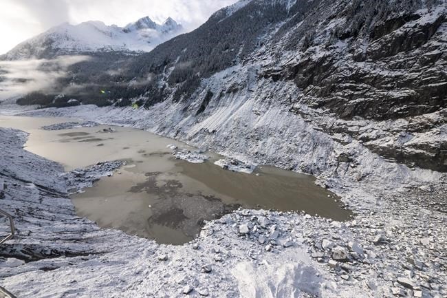
A retreating glacier in a remote British Columbia valley, shown in a Dec.18, 2020 handout photo, set off a massive landslide that created a 100-metre tall tsunami, wiped out kilometres of salmon habitat and was heard all the way to Australia, a study says.
Image Credit: THE CANADIAN PRESS/HO-Hakai Institute-Grant Callegari
March 30, 2022 - 7:00 PM
VANCOUVER - A retreating glacier in a remote British Columbia valley caused a massive landslide that crested a 100-metre tall tsunami, wiped out kilometres of salmon habitat and was detected as far away Australia, a study says.
The landslide on Nov. 28, 2020, sent 18 million cubic metres of rock cascading down the side of a mountain, uprooting trees and displacing soil before crashing into Elliot Creek, said the study published in Geophysical Research Letters.
Earthquake sensors at stations around the world including in Germany, Japan and Australia detected the landslide, the study said.
The slide destroyed salmon-spawning habitat over 8.5 kilometres of the creek and sent a plume of mud and organic matter more than 60 kilometres into Bute Inlet, about 150 kilometres from Vancouver, it said.
At the same time as the slide, a professor at Columbia University in New York measured a magnitude-5 earthquake in that area.
Marten Geertsema, lead author of the paper and adjunct professor at University of Northern British Columbia, said although the landslide wasn't the largest in Canada, it was "very, very enormous."
"Imagine a landslide with a mass equal to all of the automobiles in Canada travelling with a velocity of about 140 kilometres an hour when it runs into a large lake,” he said in an interview.
Geertsema said when the massive slide fell into a lake below, most of the water was drained and forced down a 10-kilometre long channel, causing widespread erosion and loss of salmon habitat. It removed about four million cubic meters of material from the creek within 10 minutes, something that would have taken thousands of years if the stream continued to flow normally, he said.
Prof. Brian Menounos, Canada Research Chair in glacier change at University of Northern British Columbia, said several factors came together to cause the slope's instability and the landslide.
"What we don't know is whether the final straw that broke the camel's back, for lack of a better phrase, was a rainstorm or unusually wet conditions during 2020," he said.
What scientists do know, he said, is that glaciers that once blanketed and held the slopes together are melting at rapid speeds due to human-induced climate change, which leaves the sides of the mountains loose and exposed.
Geertsema said the biggest impact of the landslide was on fishing habitat.
The Homalco First Nation contributed to the research and its members co-authored the study released last month, bringing their knowledge of Elliot Creek's salmon habitat, he said.
Menounos said landslides are not uncommon and have carved the landscape of continents for millenniums including creating or diverting water bodies and rivers.
However, deglaciation is expected to accelerate landslides and, in some cases, scientists have the tools and data to better map the topography beneath glaciers, which allows them to estimate such events, including new lake formations, he said.
“The ability to have perhaps half of the lake volume drained within 10 minutes or less, I mean, it was tremendously powerful and disruptive," Menounos said. "It feels very small, studying things with such power."
This report by The Canadian Press was first published March 30, 2022.
News from © The Canadian Press, 2022