Image Credit: Contributed
June 10, 2015 - 10:28 AM
OKANAGAN – The drive from the U.S. border in the south Okanagan to Vernon is one of the most scenic in the province, but has it changed much in the last 49 years?
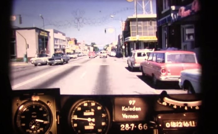
A three part series released by the Ministry of Transportation this week shows footage taken from the dash of a car driving along Okanagan Highway in 1966. According to Sonia Lowe of Transportation B.C., a single, 16-millimetre, colour exposure was taken every 85 feet. Also included at the bottom of the frame is instrumentation used to identify location and measure distance.
“The instrumentation gives approximate measurements of some of the roadway features, but the major advantage of the photographs is that they present the viewer with sufficient scope and accuracy to often substitute for a visit to the site,” a release from the ministry says. “There are many occasions when Department personnel can save time and have a better understanding of problems described in correspondence, including for example, examination of accident sites, traffic control features, alignments and general conditions.”
The footage shows south Okanagan orchards, wooden bridges, vineyards, scenic lookouts over Skaha and Okanagan Lake. Many of the roads we still use today but are nonetheless largely unrecognizable.
The first video, which starts north of the U.S. border in Osoyoos, is around six minutes long. It goes through Kaleden before arriving in the south Okanagan’s biggest city.
The second video, from Penticton to Kelowna, continues along Okanagan Highway, across the original, two-lane floating bridge and into the heart of the Okanagan.
Part three in the series starts just before the Kelowna International Airport on Highway 97. You will see Wood and Duck Lake’s before passing through the tiny town of Winfield on your way to Vernon.
The three videos are part of a Ministry of Transportation series that were used by road engineers to study major transportation corridors around the province. Other videos cover the Fraser Valley and parts of Vancouver Island.
What do you recognize in these videos? What has changed most in your mind? Share your thoughts in the comments below.
To contact the reporter for this story, email Adam Proskiw at aproskiw@infonews.ca or call 250-718-0428. To contact the editor, email mjones@infonews.ca or call 250-718-2724.
News from © iNFOnews, 2015