
The North Thompson River in Kamloops.
(GLYNN BROTHEN / iNFOnews.ca)
April 08, 2016 - 11:30 AM
ELEVATED RISK OF FLOODING IN THE OKANAGAN AS RESULT OF BIG SNOW PACK
THOMPSON-OKANAGAN - What a difference a year makes as measured by the snow in B.C.’s Interior mountains.
The snow pack in most of the river basins in the Southern Interior are well above average, unlike 2015, and continued warm weather means the annual spring freshet may arrive as much as three weeks earlier than normal.
B.C.’s River Forecast Centre’s April report shows an average snowpack of 131 per cent in the Okanagan region, up eight per cent from last month and the highest in the province.
Some individual snow measuring sites in the Okanagan are reporting snowpack percentages as high as 158 per cent of normal.
North and South Thompson regions are also above average with 112 per cent in the north and 113 per cent in the south, a touch higher than last month, despite the warmer-than-average weather.
The Boundary and Similkameen regions are sitting just above average at 106 per cent respectively. Boundary is down from 115 per cent while the Similkameen region is up from 100 per cent from last month.
Though warm, March was wetter than normal across the province, as much as 200 per cent in some areas, the report says.
Despite the warmer weather all that moisture meant seasonal growth in the snowpack last month, with the provincial average standing at 91 per cent.
However, the warm weather also means low- and mid-elevation snowpacks are well below normal at 62 per cent for measuring sites under 1,200 metres and 44 per cent for sites below 1,000 metres.
With warm temperatures, mid-season melt and more rain than normal, the report says most rivers across the province are experiencing streamflow values from 150 to 200 per cent above the median average.
That leaves the Okanagan with an elevated flood risk as river levels across the province, already high, are predicted to continue rising in the short term.
The advanced freshet is expected to contribute to summer low flows, with regions in the north particularly vulnerable.
While this winter’s El Nino has peaked and is declining, the weather phenomena will continue into late summer. Environment Canada predicts warmer-than-average temperatures across B.C. from April to June with an increased chance of above-average temperatures continuing through the summer months.
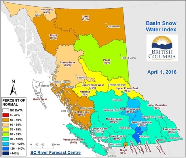
Image Credit: B.C. River Forecast Centre
Find past stories on B.C. river forecasts here.
To contact a reporter for this story, email John McDonald or call 250-808-0143 or email the editor. You can also submit photos, videos or news tips to the newsroom and be entered to win a monthly prize draw.
We welcome your comments and opinions on our stories but play nice. We won't censor or delete comments unless they contain off-topic statements or links, unnecessary vulgarity, false facts, spam or obviously fake profiles. If you have any concerns about what you see in comments, email the editor in the link above.
News from © iNFOnews, 2016