
(JULIE WHITTET / iNFOnews.ca)
June 21, 2013 - 3:40 PM
UPDATE: 3:54 p.m. June 21, 2013
A nine kilometer section of the Mission Creek Greenway Regional Park is open again.
The stretch between the Hollywood Road south parking lot entrance to Scenic Canyon Regional Park and the Field Road parking area near Gallagher’s Canyon was closed yesterday due to high creek flow and water levels and floating debris caused by the heavy rain earlier in the week.
Communications Officer Bruce Smith says, “While the creek is still flowing fast water levels have dropped allowing our Parks Services staff to check the entire length of the second phase of the Greenway recreational trail. Luckily, damage from the flooding was minor, just some trail washouts. Repairs have been made and trail conditions are safe again for public use.”
He adds, “Crews will be back in again next week finishing their repair work and Greenway users should watch for signs alerting them to crews working in the area. We also continue to encourage all visitors using creek-side trails in any Regional Park to remain alert for possible rapid, unexpected increases in water levels and flows. People and pets should stay well back from any creek banks as they may be slippery or subject to erosion.”
The Greenway trail underpass remains closed at the Casorso Road bridge and on the south side of the Gordon Drive bridge. Crews will require more time to remove debris from these areas before they can be open again for use.
UPDATE: 2:04 p.m. June 21, 2013
Though water levels in Mission Creek dropped overnight and Lakeshore Road is open again, emergency personnel are asking the public to keep a safe distance from local creeks for the next few days.
Water levels may increase again quickly, depending on the weather, according to Kelowna Deputy Fire Chief Jason Broland, and sandbags should be kept in place until further notice. Boaters should also be wary since there is the possibility of increased debris because of the recent storm and runoff.
Residents who have experienced flooding are advised to contact their insurance companies or visit www.emergencyinfobc.gov.bc.ca for more information. Information on what to do after a flood is also available at the Kelowna Fire Department’s Enterprise Way station.
Brolund said many more properties would have been flooded without the new dike constructed along Mission Creek in 2011.
“The work has paid for itself many times over,” said Brolund. “It’s a great example of how directing response costs toward mitigation and preparedness pay off in the long term.”
Just over 18 months ago, the province provided funding for the dike and work was coordinated by the City of Kelowna. Brolund says the high flows experienced in the last 24 hours on Mission Creek would have resulted in much more widespread flooding, along with large financial losses and response costs.
This morning, emergency crews are working with provincial authorities to address a property in the 11000 block of on Highway 33 in Joe Rich. A portion of the house and two trailers have been washed away, with one trailer is wedged under the bridge on Highway 33. Highway 33 remains open at this time.
3:26 p.m. June 20, 2013
A section of the Mission Creek Greenway has been closed due to the rapid rise in the water level and flow of Mission Creek.
Regional District Communications Officer Bruce Smith says, “Until conditions return to a safe level and it’s safe for our staff to assess trail conditions, the complete Phase 2 section of the Greenway corridor is closed from the Hollywood Road south entrance of Scenic Canyon Regional Park to the end of the trail off Field Road. The north creek-side section of the Greenway along Phase 1 from Lakeshore through Mission Creek Regional Park is still open but we’re urging people to use extreme caution and keep away from the banks due to the rise in water levels and increased flow resulting from the recent rainfall.”
Because of the rising water levels along Phase 2 and continued forecast of rain there is concern for public safety because of the unpredictability of the creek. There is also the potential for further rapid increases in water flows and levels and erosion of the banks.
This morning, for the fourth time this spring, rising waters forced the closure of the Greenway trail underpass at the Casorso Road bridge and the south side of the Gordon Drive bridge. Pedestrians and cyclists are asked to use caution and only cross Casorso Road when it is safe. Motorists are also asked to watch for Greenway users who may be crossing the road in this area while the underpass is closed.
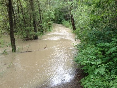
Greenway Phase 2 area.
Image Credit: Contributed
News from © iNFOnews, 2013