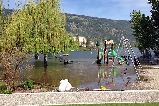
Image Credit: Contributed/Alan Gatzke
Republished May 26, 2017 - 9:00 AM
Original Publication Date May 10, 2017 - 11:24 AM
UPDATE: 5:09 p.m. Thursday, May 25, 2017
CENTRAL OKANAGAN - Two new Evacuation Alerts have been issued for some waterfront properties in the City of West Kelowna and Westbank First Nation.
West Kelowna
-
1302 to 1454 Green Bay Road
-
3660 to 3697 Green Bay Landing
-
3575 to 3636 Wiig Road
-
Westbank First Nation IR#10
-
Waterfront lots from the W.R. Bennett Bridge north to Old Ferry Wharf Road
-
Several lakefront cabins on Lindley Road
Residents in these affected areas should be prepared to leave their homes on short notice should conditions along the waterfront change. If they haven’t already, they may also wish to take steps to protect their properties from potential flooding by sandbagging and moving any items from crawlspaces and basements.
For detailed information about these Evacuation Alerts please visit the Regional Emergency Program website map: www.cordemergency.ca/map.
An afternoon of sunshine is expected to duplicate itself through the weekend. Combined with rising daytime temperatures into the 30s, we can expect to see more high elevation snowpack melting and flowing into some creeks and into area lakes raising levels further, although the rate of rise is predicted to slow over the next day or so.
Property owners are still encouraged to protect their structures and properties to the recommended level of 343.6 metres. That 60 additional centimeter buffer allows for potential wave action, weather related conditions and any additional levels that may fluctuate around the 343 metre mark that was initially predicted for Okanagan Lake.
To help with protecting private properties to the recommended 343.6 metre mark, go to the Flood FAQs section of www.cordemergency.ca/beprepared. It has directions on how to measure for flood levels and build barriers to the appropriate height to account for both lake level flooding and wave action.
Sand and sandbags are continually being replenished at locations throughout the Central Okanagan to help those in need. Find detailed information on sand pile locations and information about vulnerable areas throughout the region at www.cordemergency.ca/map.
From May 8th through this afternoon, 566 truckloads of sand have been delivered to these locations across the region. As well, more than 930,000 sandbags have been ordered.
People who would like to help their neighbours of those residents filling sandbags are encouraged to stop by any of the various sand and sandbag spots.
Boating on area lakes is still discouraged due to potential debris hazards and the shoreline erosion impact of any waves that are generated. In addition, with some area creeks and streams expected to rise over the next week with melting snow, recreational trail users should use caution, stay back from creekbanks and watch for unexpected rapid flow and level increases.
12:16 p.m. Thursday, May 25, 2017
WEST KELOWNA - Free bulk water is being offered to all West Kelowna property owners who have Okanagan Lake intakes.
The City of West Kelowna is extending the offer since Interior Health issued a Boil Water Notice to anyone drawing drinking water from Okanagan Lake within 300 meters of a bypass that is temporarily discharging treated wastewater near Pebble Beach. The notice applies particularly to residences between 2523 and 2589 Whitworth Road that are not connected to the City of West Kelowna’s Powers Creek Water Treatment Plant. It should also be noted that Pebble Beach is closed and swimming is discouraged within 150 meters of the bypass outfall.
The offer of free bulk water is also being extended, as a courtesy, to other lakefront property owners with their own intakes, given that the three City of West Kelowna systems that draw from the lake – Pritchard, Sunnyside and West Kelowna Estates – remain on Water Quality Advisories. The advisories for the three water systems were issued due to above normal turbidity at their intakes caused by spring runoff.
The free bulk water can be accessed at a filling station at the corner of Shannon Lake and Asquith Roads. The tap is located on the Asquith Road/Kinsmen Park side of the station. Users need to bring their own containers, and hoses if needed, and ensure they are clean and suitable for potable water.
West Kelowna Council directed staff to refit the station to allow free access given the water quality advisories affecting the Pritchard, Sunnyside and West Kelowna Estates Systems and the Tsinstikeptum 9 System in Westbank First Nation, and the boil water notice impacting residents in Peachland.
The filling station provides water treated via the state of the art Powers Creek Treatment Plant, which uses methods including filtration, UV radiation and chlorination.
The free access is granted for the duration of the current water quality advisories.
11:07 a.m. Thursday, May 25, 2017
CENTRAL OKANAGAN - It’s a phrase often heard during auctions and telethons: “Where are we going?” The response: ‘Higher’.
That’s the case with lakes, creeks and streams across the Central Okanagan during this ongoing weather driven response to flooding.
And in the next week, you can expect to see further increases as the melting snowpack in upper watershed elevations increases with daytime temperatures expected in the low 30s late this weekend.
Tuesday night’s high winds are a good indication of what we could expect and perhaps more, as Okanagan Lake continues rising. This morning, Okanagan Lake was at the 342.98 metre mark, up three centimetres from yesterday. That’s just two centimetres below the projected 343 metre figure.
In response to this, local governments throughout the region are checking, monitoring and bolstering defences in place to protect critical infrastructure and upland areas. This is what private property owners along water bodies should also be doing. Prepare for the worst and hope for the best!
Sand and sandbags are continually being replenished at locations throughout the Central Okanagan to help those in need. Find detailed information on sand pile locations and information about vulnerable areas throughout the region at www.cordemergency.ca/map.
To check whether a property needs flood protection, go to the Flood FAQs section of www.cordemergency.ca/beprepared. It has directions on how to measure for flood levels and build barriers to the appropriate height to account for both lake level flooding and wave action.
Boating on lakes in the Central Okanagan is still discouraged and everyone appreciates those boaters who have found other pursuits. Shoreline degradation from preventable wave action remains a high priority and concern. For those who must boat, please keep speeds down within 30 metres of the shoreline and watch for potentially dangerous floating and submerged debris.
A reminder that Creekside trails can be dangerous. Recreational users should stay well back as banks can be subject to undercutting and erosion. With the potential for increased snowmelt over the next week, they should also be aware of unexpected rapid increases in creek flows and levels.
Beaches remain closed as emergency crews maintain flood protection barriers.
4:58 p.m. Wednesday, May 24, 2017
CENTRAL OKANAGAN - The slow, steady rise in lake levels to record heights could accelerate later this week as warm weather causes creeks to swell with snow melt.
Wind, rain, sun – any one of these elements in excess can cause its own unique problems for Central Okanagan properties this spring.
Strong winds create damaging waves on already overfilled lakes. Too much rain adds to the creek flows and further saturates soggy slopes. Sunny conditions cause rapid snowpack melt, filling creeks and flowing into local lakes.
This alternating state of weather patterns is expected to last for weeks, and with lakes this full, it will be weeks before they peak and begin to drain. As a result, any wind, rain or sun is going to bring different conditions that residents near creeks and lakes will need to prepare for.
The advice for residents who live near water is to remain vigilant about changing conditions and keep flood protection in place until further notice. The break in the weather today offers residents a chance to shore up flood protection. Residents are urged to continue to help neighbours with this work, with sandbag stations welcoming volunteers to help fill and carry sandbags.
Sandbagging stations are stocked and replenished daily at several locations throughout the Central Okanagan. Visit www.cordemergency.ca/map to find sand pile locations and information about vulnerable areas throughout the region.
Beaches remain closed as emergency crews maintain flood protection barriers.
Okanagan Lake rose 4.5 centimetres overnight to a new level of 342.95 metres, five centimetres below its highest recorded level of 343 metres in 1948.
A break in the weather today offers residents a chance to fortify flood protection. With lakes approaching historic volumes, the high water levels are expected to remain well into July. Residents are urged to keep protection in place for the foreseeable future.
A return to warm conditions later this week will speed up the volume of snow melting at the higher elevation watersheds, further boosting creek flows and area lakes to rise.
Boating is not recommended on Central Okanagan lakes as levels are rising and swells in wind create more severe conditions. Any boats still on lifts at docks should be removed.
3:36 p.m. Wednesday, May 24, 2017
CENTRAL OKANAGAN - The Regional District of Central Okanagan is upgrading a precautionary Public Health Advisory issued last night to a Boil Water Notice regarding the discharge of treated effluent from the Westside Regional Wastewater Treatment Plant into Okanagan Lake.
After further discussions with Interior Health and in accordance with Ministry of Environment regulations, the Regional District has been made aware that residences between 2523 and 2589 Whitworth Road are not connected to a municipal water supply and may draw water from Okanagan Lake.
As a result, a Boil Water Notice is in place for anyone drawing drinking water from Okanagan Lake within 300 metres of the additional temporary Wastewater Treatment Plant bypass discharge located just off the Pebble Beach Park shoreline. Affected residents should boil any water used for drinking, cooking, washing produce or fruit, making beverages and ice or brushing teeth for at least one minute or secure an alternate source of safe drinking water.
The Regional District is providing this Boil Water Notice directly to those affected property owners. As well, following a recommendation from Interior Health, the Regional District is providing bottled water for affected residents.
Also as a precaution, swimming is not recommended within 150 metres of the temporary park discharge for treated effluent. The municipal park was closed last week after flood protection works were installed.
The additional pump is required because higher than normal lake levels have caused a decreased flow of treated effluent from the Wastewater Treatment Plant outfall in Okanagan Lake.
Both the Ministry of Environment and Interior Health were consulted last week when the supplemental pump was added for the Westside Regional Wastewater Treatment facility.
8:49 a.m. Wednesday, May 24, 2017
CENTRAL OKANAGAN - High winds on overfilled lakes last night caused localized flooding for residences in low lying areas on Central Okanagan lakes.
Emergency crews are out today, May 24, clearing windfall from streams, inspecting and assessing flood protection measures and infrastructure to determine the top priorities for further action. Residents should be aware of the risk of falling trees within saturated ground conditions near lakes and creeks.
Okanagan Lake rose 4.5 centimetres overnight to a new level of 342.95 metres, five centimetres below its highest recorded level of 343 metres in 1948.
A storm surge phenomenon on lakes, created by high winds pushing a high volume of water in one direction, in addition to wave action on top of the surge, posed a serious threat to property and fortifications.
With wind gusts of up to 70 km/h last night, residents were advised that it was too late to begin sandbagging efforts in these conditions and to instead ensure their own personal safety.
A break in the weather today offers residents a chance to fortify flood protection. With lakes approaching historic volumes, the high water levels are expected to remain well into July. Residents are urged to keep protection in place for the foreseeable future.
A return to warm conditions later this week will speed up the volume of snow melting at the higher elevation watersheds, further boosting creek flows and area lakes to rise.
Boating is not recommended on Central Okanagan lakes as rising levels are moving faster and swells in wind creating more severe conditions. Any boats still on lifts at docks should be removed.
Public health advisory for Westside Regional Wastewater Treatment Plant treated effluent bypass
As a result of further consultation with Interior Health, the Regional District is issuing an advisory in the interest of protecting public health relating to the temporary pumping bypass discharging treated effluent from the Westside Regional Wastewater Treatment Plant into Okanagan Lake.
Interior Health recommends anyone drawing drinking water from Okanagan Lake within 150 meters of the bypass discharge, located just off Pebble Beach Park in West Kelowna, should boil or secure an alternate source of safe drinking water.
In addition, swimming is discouraged within 150 meters from the temporary treated effluent bypass discharge off the Pebble Beach park shoreline. The park located along Whitworth Road, was closed by the City of West Kelowna last week as flood protection works were installed.
Both measures are precautionary in nature.
Due to rising lake levels and an increase in flows of wastewater into the treatment plant from those residents served in West Kelowna, Peachland and the Westbank First Nation reserves #9 and #10, last week the Regional District installed and continues to operate an additional pump, boosting the outfall capacity of the plant’s treated effluent. The treated effluent is the same material that is flowing out of the plant outfall into Okanagan Lake following the complete treatment process.
The additional pump is required because higher than normal lake levels have caused a decreased flow of treated effluent from the plant’s outfall in Okanagan Lake.
Both the Ministry of Environment and Interior Health were consulted regarding the addition of a supplemental pump from the Westside Regional Wastewater Treatment facility.
4:05 p.m. Tuesday, May 23, 2017
CENTRAL OKANAGAN - Winds forecasted for this evening will test flood protection measures with expected wind gusts from 40 to 60 kilometres per hour. The shoreline erosion from wave action along unprotected waterfront properties as area lakes levels continue to rise is an area of concern.
Waterfront property owners who haven’t taken measures to protect their structures and properties including the removal of boats from boatlifts should take measures now to minimize the impact of flooding and damage to private property.
A risk of falling trees within saturated ground conditions near lakes and creeks is high. The risk can be increased by high winds expected this evening.
Warmer temperatures later in the week will speed up the volume of snow melting at the higher elevation watersheds, further boosting creek flows and area lakes to rise.
To check whether a property needs flood protection, go to the Flood FAQs section of www.cordemergency.ca/beprepared, to get directions on how to measure for flood levels and build barriers to the appropriate height to account for both lake level flooding and wave action.
Sandbagging stations are stocked and replenished daily at several locations throughout the Central Okanagan. Volunteers are still welcome at sand piles to help with filling and loading sandbags. Visit www.cordemergency.ca/map to find the location closest to you.
Find information on flood preparation, including sand and sandbag locations, how to effectively build sandbag walls and secure docks at www.cordemergency.ca/beprepared/flood-faq.
11:12 a.m. Tuesday, May 23, 2017
CENTRAL OKANAGAN - Okanagan Lake and water bodies across the Central Okanagan continue their rise toward record levels.
Okanagan Lake rose four centimetres since yesterday morning to 342.91 metres, surpassing the 1990 flood level of 342.87 metres. That’s just 9 centimetres below the year’s projected flood level of 343 metres.
With the forecast calling for gusty winds later tonight and early tomorrow morning, wind-driven wave action could test waterfront flood protection measures. There’s a potential for rain with possible thundershowers later today as a cold front moves through. As well, the warmer than normal temperatures through today have resulted in higher levels and flows in area creeks and streams, further reducing the snowpack in the higher elevations.
Waterfront property owners who haven’t taken measures to protect their structures and properties from flooding should do so. During surveillance flights and a detailed Okanagan Lake shoreline survey by the Emergency Operations Centre, officials noted that many lakefront properties at risk of flooding have not adequately protected the shoreline to 343.6 metres, which is the projected high lake level of 343 metres plus a buffer for wave action.
To determine whether your property needs flood protection, go to the Flood FAQs section of www.cordemergency.ca/beprepared. That’s where you’ll find instructions on how to measure for flood levels and build barriers to the appropriate height to account for both lake level flooding and wave action.
Sandbagging stations are stocked and replenished daily at several locations throughout the Central Okanagan. Volunteers are still welcome at these locations to help with filling and loading sandbags.
Visit www.cordemergency.ca/map to find the location closest to you.
Boating is still not recommended on Central Okanagan lakes as levels are moving higher and for safety reasons with the vast amount of floating and submerged debris and docks.
Find information on flood preparation, including sand and sandbag locations, how to effectively build sandbag walls and secure docks at www.cordemergency.ca/beprepared/flood-faq.
3:59 p.m., Friday, May 19, 2017
CENTRAL OKANAGAN - Due to extraordinarily high Okanagan Lake levels, the damage that watercraft wakes can cause to properties, and to protect anti-flood measures installed along the shore, the City of West Kelowna is closing its boat launches.
A number of waterfront parks have also been closed; and, sand and sandbag locations have been restocked as part of the City of West Kelowna’s ongoing flood protection response.
Effective immediately, and until further notice, the boat launches at Gellatly Bay and in Casa Loma have been closed to recreational use. The City of West Kelowna will reopen the launches when lake levels have subsided and the threat of property damage from boat wakes has abated. Patrol officers will remain available on site to open the Gellatly launch for emergency and commercial uses and for residents who need to get their boats off the lake.
Until further notice, a number of West Kelowna parks will also remain closed due to the flood threat caused by steadily rising lake levels and to ensure the preservation of protective measures that have been installed along the shoreline.
Closures are in effect at:
-
Pritchard Park
-
Pebbles Beach
-
Waterfront portion of the Gellatly Beach access
-
Marina Park
-
Aberdeen Park
-
Jennens Beach Access
The city has installed sandbag walls at a further 27 beach accesses. At these locations, visitors are asked to stay clear of the walls and keep to the upland side of them to prevent the protective barriers from being damaged or moved.
The public is reminded not to tamper with existing berms and bladder dams or remove sandbags that have already been installed to protect existing infrastructure and public properties.
Residents in West Kelowna and Westbank First Nation who do need sand and sandbags can get them free of charge, at the following locations:
-
Casa Loma; 2606 and 2714 Casa Loma Road
-
515 Highway 97 South (WFN Government Building), right of the main parking lot
-
Green Bay; 1341 Green Bay Road, Osprey Park and at the Wiig Road cul-de-sac
-
Pritchard; 1651 Pritchard Drive
-
Hitchner/Jennens; 4081 Hitchner Road
-
Across from the WFN Works and Utilities yard at the intersection of Cougar and Elk Roads (approximate address 3500 Red Cloud Way)
-
Gellatly Bay; 2589 Whitworth Road near Pebble Beach Park
Residents are strongly encouraged to take proactive measures to protect their own properties as civic crews continue to focus on installing measures to protect essential public infrastructure. And those residents who have taken steps to protect their properties from flooding are reminded to leave measures in place and to keep all debris on beaches. Debris will cushion against waves and reduce erosion.
2 p.m. Friday, May 19, 2017
CENTRAL OKANAGAN - Boating is not recommended this weekend, but boaters choosing to access Okanagan Lake are urged to avoid several areas at risk due to high waters and wave action.
The Emergency Operations Centre is asking boaters to avoid the following locations:
Peachland
-
The entire downtown waterfront; specifically, Heritage Park to Buchanan
-
All day use docks and wharfs (closed)
-
Princeton boat launch (closed)
West Kelowna
-
Green Bay area
-
Casa Loma area
-
Pritchard Drive area
-
Whitworth Road area
Lake Country
-
Tween Lakes (canal) and entire Oyama isthmus area
-
Carrs Landing
-
Okanagan Centre
-
Turtle Bay
Westside Road (RDCO)
-
Wilson’s Landing
-
Fintry area
-
Killiney Beach area
Kelowna
-
The entire waterfront between Poplar Point and Cedar Creek
Boating is not recommended due to unsafe conditions resulting from flooding and high water levels. Flooding has deposited significant debris in Okanagan Lake, including large trees and branches, making navigation on the lake hazardous.
Boat wakes can have significant impact on vulnerable properties and signage is being posted at boat launches and shared with private moorage organizations encouraging boaters to go slow and avoid causing wakes, particularly close to shore.
Boaters are reminded that they can be fined for operating a power-boat over 10 km/h within 30 metres of shore. Boaters who choose to disregard safety notifications may be also be fined.
Officials will be on the lake this weekend monitoring boaters and vulnerable areas.
Municipal and public safety crews continue to install flood mitigation works including sand bag walls, bladder dams and gabion barriers. The public is being asked to not touch these installations for their own safety and to ensure the continued protection of community infrastructure and property. Debris washed up on beaches should be left for the time being. Please do not remove logs and other wood material as it helps limit erosion caused by wave action. When the flood risk has passed, officials will provide notification of how the beach debris will be removed.
For current information on the status of boat launches, waterfront park and beach closures, please refer to local government websites.
Emergency Support Services will be closed from Saturday, May 20 to Monday, May 23, reopening on Tuesday, May 24 from 11 a.m. to 2 p.m. For urgent support service matters please call 250-469-8490.
Find information on flood preparation, including sand and sandbag locations, how to effectively build sandbag walls and secure docks at whttp://www.cordemergency.ca/beprepared.
8 a.m. Friday, May 19, 2017
CENTRAL OKANAGAN - Flood preparations in response to rising lake levels have been underway throughout the week.
Okanagan Lake rose 2.5 cm yesterday, May 18, and the lake level is now at 342.779. Heading into the long weekend, there are some safety considerations for residents and visitors while taking in activities in the Central Okanagan.
Boating Safety and Docks
Boating on Central Okanagan Lakes is not recommended due to safety and wave action concern. Boaters who choose to access local lakes are asked to use extreme caution and watch for floating debris. Boaters are also asked to keep their speeds and wakes down to reduce shoreline erosion from preventable wave action. In preparation of potential flooding, docks or boats must be properly secured.
In preparation of potential flooding, docks or boats must be properly secured. Some tips include:
-
If anchored, make sure the anchor lines are long enough, so they don’t snap if water rises too high
-
Ensure boats are secured
-
If you have a pull-up dock, pull it up as high as possible
-
Secure the dock using sandbags or weighted barrels on the edges of the dock
-
Remove all loose items from the dock, but do not clean any debris from shoreline
-
Stay away from fast moving waters
-
Boat owners with boats on lifts may choose to remove their boat from the lift and trailer it for safe storage.
Waterfront Beaches and Parks
Flood preparations and rising water levels have impacted access to some beaches and waterfront parks across the region. The public is asked to not touch flood protective measures that have been put in place throughout the region. Sand bag walls, bladder dams and gabion barriers have been placed with care to protect infrastructure and property and should not be climbed on or altered in any way.
For current information on the status of boat launches, waterfront park and beach closures or partial closures refer to the local governments' websites.
To find information about the many opportunities to exploring the region’s parks and activities, refer to local websites or www.tourismkelowna.com.
Keep Debris in Place
Debris washed up on beaches should be left there for the time being. Please do not remove logs and other wood material as it helps limit erosion caused by wave action. When the flood risk has passed, officials will provide notification of how the beach debris will be removed.
See the most up to date information on sand and sandbag locations visit cordemergency.ca/map.
Updated Regional Park Closures
As Central Okanagan lakes continue rising, Regional District parks crews are busy stacking sandbags to proactively protect many waterfront parks.
Among those Regional Parks now armed with sandbags: Kalamoir (Lakefront trail); Okanagan Centre Safe Harbour; Bertram Creek (pumphouse, east beach); Kaloya (pumphouse) and the Gellatly Nut Farm (buildings, waterfront).
Communications Officer Bruce Smith says, “Staff identified areas and amenities within these and other regional parks that need to be protected from potential flood damage. They’ll continue installing protective works in high risk areas. While these parks remain open, we ask that visitors not touch any sandbags and other flood protection.”
The small boat launch located at Fintry Community Park Access #1 at the end of Fintry Delta Road and the main launch at Okanagan Centre Safe Harbour Regional Park on Okanagan Centre Road West are still open but may be subject to closure on short notice for safety reasons due to changing lake levels and weather conditions.
Smith adds, “The threat of flooding continues and there could be unexpected increases in water levels along area creeks and streams. Visitors and leashed pets should stay back from creek banks, which can be slippery and subject to erosion.”
The following Regional Parks remain closed:
-
Glen Canyon Regional Park from the Acorn bridge downstream to the Gellatly Road parking area and from the Constable Neil Bruce entrance upstream to the Covington Crescent entrance at Last Mountain Community Park
-
Hardy Falls Regional Park
-
Mill Creek Regional Park
-
Killiney Beach Community Park – including the boat launch is closed to all visitors, with limited vehicle access through the park for waterfront properties.
While these parks are closed, the Regional District encourages residents to visit many other regional parks that are not affected by flooding and rising waters. You can view them at www.regionaldistrict.com/pickapark
Regional Parks staff is monitoring creek levels in all these areas and when safe will be assessing the condition of bridges, trails and other amenities in these parks. Parks may be closed on short notice should conditions change.
11 a.m. Thursday, May 18, 2017
CENTRAL OKANAGAN - There are isolated areas within the Central Okanagan experiencing impacts from rising lake levels.
Okanagan Lake levels rose two centimetres to 342.75 metres since yesterday, May 17. These conditions are expected to last well into June due to record water levels in area lakes and the amount of snow in higher elevations expecting to melt with the warmer temperatures in the forecast.
Public works crews continue today, May 18, installing bladder dams in Kelowna at Kinsmen Park, Sutherland Park and Tug Boat Park as well as sandbag walls at Manhattan Drive Beach Access and Watt Road. The public is asked to stay back from protective flood measures. This includes climbing or jumping on bladder dams and sandbag walls.
The locations for these works are based on a survey of waterfront properties on Okanagan Lake that are most prone to flooding from rising lake levels. Some of the prime installation considerations include protecting public infrastructure and foreshore areas that protect many upland properties. Specific areas were also determined by their risk of flooding and how easily and efficiently these barriers can be put in place. Crews will continue to install barriers in the coming days on a priority basis.
Residents in low-lying and waterfront areas that may be affected by flooding from rising lake levels are encouraged to use sandbags or other measures to protect structures on their property. For instructions on flood preparations such as protecting property, securing docks and finding sandbag locations visit cordemergency.ca.
Heading into the long weekend, flood preparations and rising water levels may impact some access to beaches and waterfront parks in various local governments across the region. Visit local government websites to check the current status of parks and beaches. For tourism information and exploring of the many parks in the region refer to local government websites or Tourism Kelowna.
Boaters on lakes in the Central Okanagan are reminded to keep their speeds and wakes down to prevent shoreline erosion from preventable wave action. They should also watch for floating debris. In preparation of potential flooding, docks or boats must be properly secured. Boat owners with boats on lifts may choose to remove their boat from the lift and trailer it for safe storage.
Debris washed up on beaches should be left there for the time being. Please do not remove logs and other wood material as it helps limit erosion caused by wave action. When the flood risk has passed, officials will provide notification of how the beach debris will be removed.
See the most up to date information or to register to for e-updates visit cordemergency.ca.
4:52 p.m. Wednesday, May 17, 2017
CENTRAL OKANAGAN - Evacuation Orders have been rescinded for all properties affected by flooding on Okanagan Indian Band Reserve #7.
This includes Meadow Brook Estates, Holiday Park Resort, Turtle Lodges and other properties within the reserve.
Those people no longer under evacuation may continue to experience increasing lake and ground water levels and should leave any flood preparations, such as sandbags, in place. To check on the status of orders and alerts visit www.cordemergency.ca/maps.
There are isolated areas within the Central Okanagan that are currently experiencing impacts from rising lake levels.
In downtown Kelowna for example, dewatering pumps have been in place and continue to work to prevent flooding in civic properties with potential benefits for other area properties. The Westside Regional Wastewater Treatment Plant has added additional pumping capacity to support reduced outfall flow of treated effluent into Okanagan Lake.
These conditions are expected to last well into June as water levels in area lakes are at seasonal record levels and there is snow still to melt in the mountain watersheds not to mention the impact unpredictable weather events may add.
Public works crews continued today, May 17, installing flood protection measures along beaches and lakefront areas.
Some of the foreshore areas where bladder dams, gabion barriers and sandbags were installed today in the City of Kelowna include City Park, Strathcona Park and Rotary Park. Protective works were previously installed along Manhattan Drive; south of the W.R. Bennett Bridge and along waterfront properties in the area of the Kelowna General Hospital campus as well as locations in West Kelowna.
The locations for these works are based on a survey of waterfront properties on Okanagan Lake that are most prone to flooding from rising lake levels. Some of the installation considerations include protecting public infrastructure and foreshore areas that protect many upland properties. Specific areas were also determined by their risk of flooding and how easily and efficiently these barriers can be put in place. Crews will continue to install barriers in the coming days on a priority basis. The public is requested to stay away from built flood protection measures.
In an ongoing effort to help City of Kelowna residents in low-lying and waterfront areas that may be affected by flooding from rising Okanagan Lake levels, pallets of sandbags are being dropped off along roads and streets in these areas where no public flood prevention works are proposed. Residents are encouraged to use these sandbags to protect their properties.
Other residents and property owners concerned about flooding are encouraged to use sandbags or other measures to protect structures on their property. Updated information on sand and sandbag locations is available at www.cordemergency.ca.
The levels of Okanagan Lake and other lakes in the Central Okanagan continue to rise, as the volume of water entering from the higher elevations is greater than that flowing out. Unpredictable weather conditions such as warm temperatures, wind and rain will impact the potential for flooding.
Please do not remove any debris washed up on beaches. Logs and other wood material acts as a buffer and helps limit erosion caused by wave action. When the flood risk has passed, officials will outline how to remove and dispose of this material.
Boaters on lakes in the Central Okanagan are reminded to keep their speeds and wakes down to prevent shoreline erosion from preventable wave action. They should also watch for floating debris. In preparation of potential flooding, docks or boats must be properly secured. Boat owners with boats on lifts may choose to remove their boat from the lift and trailer it for safe storage.
For tips on protecting boats and a video on how to docks visit the Flood FAQ page at www.cordemergency.ca/beprepared/flood-faq
See the most up to date information at www.cordemergency.ca and for the latest updates and maps.
11:21 a.m. Wednesday, May 17, 2017
CENTRAL OKANAGAN - The Evacuation Orders remain in place affecting properties within the Okanagan Indian Band reserve #7 including those specifically identified in the Holiday Park Resort and the Turtle Lodges.
Any change to these Evacuation Orders will be made only when it is safe to allow residents to return.
Evacuation Orders and Alerts are up-to-date at www.cordemergency.ca/map.
Okanagan Lake rose more than three centimetres to 342.736 metres since yesterday morning, May 16.
Residents in low-lying and waterfront areas that may be affected by flooding from rising lake levels are encouraged to use sandbags or other measures to protect structures on their property.
Updated information on sand and sandbag locations is available at www.cordemergency.ca.
Once again today, May 17, residents may see proactive flood protection measures from local government public works staff along beaches and the lakefront in municipalities.
Bladder dams, gabion barriers and sandbags will continue to be installed at a number of locations along the foreshore based on a survey of waterfront properties on Okanagan Lake. The survey confirmed the location of those areas that are most prone to flooding from rising lake levels. Some of those areas with waterfront flood protection installed include those neighbourhoods between the W. R. Bennett Bridge and close to the Kelowna General Hospital campus and in West Kelowna and along Bellevue Creek.
Barriers in other areas at risk of flooding will be installed on a priority basis in the following days, making the most efficient use of work crews to get to as many areas as possible before the lake rises forecasted levels.
The primary considerations where flood protection barriers will be placed include protecting public infrastructure and foreshore areas where these measures can protect many upland properties. Protection for specific areas was also determined by their risk of flooding and how easily and efficiently the barriers can be put in place, giving crews time to complete more shoreline.
Crews are also continuing to place wooden stakes along waterfront properties to show where the survey determined the lake level could reach when it hits the 343.6-metre level. That point above sea level represents the elevation of the flood projections including a buffer for wave action. Residents are asked not to move or remove the stakes or any other flood protection measures.
To establish how flood levels will impact property
-
Use today’s lake level of 342.74 metres
-
Use a tape measure to measure an additional 86 centimetres vertically above the existing water level. This will equal 343.6 m, which includes the projected flood level plus buffer to protect from wave action.
-
Mark this level again something stationary such as a tree, fence or wall. Build flood protection measures up to that height.
All previously placed sandbags and other protective devices should be left in place.
Debris washed up on beaches should be left there for the time being. Please do not remove logs and other wood material as it helps limit erosion caused by wave action. When the flood risk has passed, officials will provide notification of how the beach debris will be removed.
Tips for dock owners and boaters
-
Anyone boating on lakes in the Central Okanagan is reminded to keep speeds and wakes down to prevent shoreline erosion. They should also watch for floating debris.
-
In preparation of potential flooding, docks or boats must be properly secured. Some tips include:
-
If anchored, make sure the anchor lines are long enough, so they don’t snap if water rises too high
-
Ensure boats are secured
-
If you have a pull-up dock, pull it up as high as possible
-
Secure the dock using sandbags or weighted barrels on the edges of the dock
-
Remove all loose items from the dock, but do not clean any debris from shoreline
-
Stay away from fast moving waters
Boat owners with boats on lifts may choose to remove their boat from the lift and trailer it for safe storage.
Residents are reminded that the BC Wildfire Service camp in West Kelowna is a restricted area. No information is available at this location and they should refer to the Regional Emergency Program website www.cordemergency.ca for the latest updates.
Stay up-to-date
See the most up to date information at www.cordemergency.ca and for the latest updates and maps.
4:55 p.m. Tuesday, May 16, 2017
Evacuation Orders and Alerts rescinded for Lake Country
A number of properties in Lake Country are no longer under Evacuation Order and Alert.
Rescinded Evacuations Orders in Lake Country include:
-
11019 Bottom Wood Lake Road (includes property signed as 11039 Bottom Wood Lake Road)
Rescinded Evacuation Alerts in Lake Country include:
-
11080 Bottom Wood Lake Road
-
11110 Bottom Wood Lake Road
-
11124 Bottom Wood Lake Road
-
11136 Bottom Wood Lake Road
-
11152 Bottom Wood Lake Road
-
11166 Bottom Wood Lake Road
-
11180 Bottom Wood Lake Road
-
11194 Bottom Wood Lake Road
-
11218 Bottom Wood Lake Road
-
11039 Deldor Road
-
11087 Deldor Road
-
11109 Deldor Road
-
11121 Deldor Road
-
11131 Deldor Road
-
11141 Deldor Road
-
11151 Deldor Road
-
11165 Deldor Road
-
11225 Deldor Road
-
3186 Mayrus Road
-
3010 Reimche Road
-
3050 Reimche Road
-
3090 Reimche Road
-
1-3091 Reimche Road
-
3115 Reimche Road
-
3118 Reimche Road
-
101-3155 Reimche Road
-
102-3155 Reimche Road
-
103-3155 Reimche Road
-
104-3155 Reimche Road
-
105-3155 Reimche Road
-
106-3155 Reimche Road
-
107-3155 Reimche Road
-
108-3155 Reimche Road
-
109-3155 Reimche Road
-
110-3155 Reimche Road
-
111-3155 Reimche Road
-
112-3155 Reimche Road
-
113-3155 Reimche Road
-
114-3155 Reimche Road
-
115-3155 Reimche Road
-
116-3155 Reimche Road
-
117-3155 Reimche Road
-
118-3155 Reimche Road
-
119-3155 Reimche Road
-
120-3155 Reimche Road
-
121-3155 Reimche Road
-
11326 Reimche Road
-
11610 Rogers Road
-
11656 Seymour Road
-
11668 Seymour Road
-
11680 Seymour Road
-
Seymour Road (PID 017-705-339)
-
11511 Turtle Bay Court
-
11531 Turtle Bay Court
-
11571 Turtle Bay Court
-
11591 Turtle Bay Court
-
3118 Wageman Road
-
3151 Wageman Road
-
3041 Woodsdale Road
-
3081 Woodsdale Road
-
3091 Woodsdale Road
-
3110 Woodsdale Road
-
Beaver Lake Road from Main Street to Bottom Wood Lake Road
-
Bottom Wood Lake Road from Berry Road to Lodge Road
-
Lodge Road to/from roundabout to Meadow Road
-
3193 Hill Road (Kangaroo Creek Farm)
-
10163 Konchuh Road
-
All of Meadow Road
-
Pawley Court
-
Taiji Court
-
Bottom Wood Lake Road – All the way to the lake
-
Brun Road
-
Rolyat Road
-
Redekop Road
-
Reiswig Road
-
Jeider Road
-
Woodsdale Road from trial thru to Woodsdale Court
-
Clement Road
-
Rogers Road
-
Seymour Road
-
Turtle Bay Court
-
2930 Woodsdale Road (Wood Lake RV Park and Marina)
-
2850 Woodsdale Road (Turtle Bay Pub)
-
11871 Hwy 97
Residents no longer under order or alert, may continue to experience increasing lake and ground water levels and should leave flood preparations in place.
Information on returning home after a flood
The Preparedness BC website has information to help those property owners with protecting their property from flooding and some considerations for those returning after a flood. Check out the homeowner handbook.
Interior Health also has information available for residents to consider before, during and after a flood, available here.
Information on flooding and electrical safety is also available for BC Hydro and FortisBC customers at www.bchydro.com and www.fortisbc.com respectively.
All other Evacuation Orders and Alerts remain in effect. Visit www.cordemergency.ca/map and search by address to determine if you or someone you know if under alert or order.
Conserve water & reduce sanitary sewer system strain
Residents of the Central Okanagan are reminded to conserve water, and not irrigate lawns or gardens. If pumping water from homes or property, pump onto the street, yard or into the storm drain system (grates on the street). Do not pump into the sanitary sewer system, doing so could cause water treatment facilities to become overtaxed.
12:23 p.m. Tuesday, May 16, 2017
Proactive measures to protect public infrastructure, properties
Work is ongoing to install flood protection for rising lake levels at numerous locations across the Central Okanagan. This includes measures such as bladder dams, gabion barriers and sandbags along the lakefront.
Primary considerations for the placement of flood protection barriers include protecting public infrastructure and foreshore areas where measures can protect many upland properties. Protection for specific areas was also determined by their risk of flooding and how easily and efficiently the barriers can be put in place, giving crews time to complete more shoreline.
Residents might see crews placing wooden stakes along Okanagan Lake waterfront properties to show where the survey determined the lake level could reach when it hits the 343.6-metre level. That point above sea level represents the elevation of the flood projections including a buffer for wave action. Residents are asked not to move or remove the stakes or any other flood protection measures.
Barriers in other areas at risk of flooding will be installed on a priority basis in the following days, making the most efficient use of work crews to get to as many areas as possible before the lake rises forecasted levels.
With water levels already at record highs for the time of year and snow remaining in the high elevation watersheds, the potential for flooding due to rain, wind or warm temperatures is still a risk. These conditions for area lakes and creeks are expected to last well into June.
To establish how flood levels will impact property
-
Use today’s lake level of 342.70m
-
Use a tape measure to measure an additional 90 cm vertically above the existing water level. This will equal 343.6m, which includes the projected flood level plus buffer to protect from wave action.
-
Mark this level again on something stationary such as a tree, fence or wall. Build flood protection measures up to that height.
Tips for dock owners & boaters
In preparation of potential flooding, be sure that any docks or boats are properly secured. Some tips include:
-
If anchored, make sure the anchor lines are long enough, so they don’t snap if water rises too high
-
If you have a pull-up dock, pull it up as high as possible
-
Remove all loose items from the dock, but do not clean any debris from shoreline
-
Ensure boats are secured
-
Stay away from fast moving waters
If residents have a license of tenure/occupation from the province, the dock can be covered under house insurance. If they do not, insurance will not cover it. Anyone with further questions should speak to their insurance provider directly.
For more information visit http://www2.gov.bc.ca/gov/content/industry/natural-resource-use/land-use/crown-land/crown-land-uses/residential-uses/private-moorage.
Boaters are reminded that lake levels are high and they should watch for floating debris as a significant amount has been flowing down streams and into area lakes. Boaters should also keep their distance from shorelines and if possible keep speeds down as additional wave action could cause disturbance to banks and beaches.
Stay up-to-date
To view the most up to date information and locations of sand and sandbags, go to www.cordemergency.ca and check out the latest updates and maps.
10 a.m. Tuesday, May 16, 2017
Flood barrier installation in priority locations
Okanagan Lake rose more than 2.5 cm to 342.70 m since Monday afternoon, May 15. In response, residents in some of the lowest laying areas of Kelowna might see crews deploying flood protection measures today, May 17.
Based on a survey of waterfront properties on Okanagan Lake, bladder dams, gabion barriers and sandbags will begin to be installed at a number of locations along the foreshore. The survey confirmed the location of the most vulnerable areas prone to flooding from rising lake levels.
Residents in Kelowna neighbourhoods between William R. Bennett Bridge and Kelowna General Hospital area might see work crews installing flood protection measures on the beach along the lakeshore starting today.
Work in West Kelowna is also ongoing at Pritchard Park and Pebble Park today.
Protecting infrastructure & areas most at risk of flooding
Primary considerations for the placement of flood protection barriers include protecting public infrastructure and foreshore areas where flood protection can protect many upland properties. Protection for of specific areas was also determined by their risk of flooding and how easily and efficiently the barriers can be put in place, giving crews time to complete more shoreline.
For example, adding barriers in front of about 15 homes between Royal Avenue and Atwood Place will protect the Kelowna General Hospital campus. And placing barriers in front of 20 lakeshore properties between the bridge and Burne Avenue will protect another 60 properties behind them. Crews can easily reach these areas through public beach accesses.
Residents might see crews placing wooden stakes along waterfront properties to show where the survey determined the lake level could reach when it hits the 343.6-metre level. That point above sea level represents the elevation of the flood projections including a buffer for wave action. Residents are asked not to move or remove the stakes or any other flood protection measures.
Some of flood protection barriers have already been deployed in West Kelowna and along Bellevue Creek in Kelowna.
Barriers in other areas at risk of flooding will be installed on a priority basis in the following days, making the most efficient use of work crews to get to as many areas as possible before the lake rises forecasted levels.
Debris washed up on beaches should be left there for the time being. The logs and other wood material will help limit erosion caused by wave action. When the flood risk has passed, officials will provide notification of how the beach debris will be removed.
Many still evacuated, stay prepared
Approximately 400 people remain evacuated. Emergency officials are constantly assessing possible changes in the status of remaining evacuation orders and alerts based on a variety of conditions including weather and the impact it has on lake water levels which are continuing to rise and levels and flows of area creeks. Any change to Evacuation Orders will be made only when it is safe to allow residents to return to their homes.
The Emergency Support Services reception centre at the Salvation Army at Sutherland Avenue and Burtch Road in Kelowna will be open from 11 a.m. to 2 p.m. Tuesday, May 16 to assist those who remain on evacuation order and those who require extended assistance. Evacuation Orders and Alerts are up-to-date at www.cordemergency.ca/map.
The Province of British Columbia’s Emergency Management website offers helpful information on protecting your property from, and recognizing the danger signs of landslides.
With water levels at record highs and snow remaining in the high elevation watersheds, the potential for flooding due to rain, wind or warm temperatures is still a risk. These conditions for area lakes and creeks are expected to last well into June.
All residents, including those no longer on order or alert, are reminded to keep sandbags in place until the flood watch event has fully ended. Residents with lakefront properties and next to beach edges should not remove the debris along their property, as it can act as a barricade against rising waters and minimize erosion.
Boaters be slow
Boaters are reminded that lake levels are high and they should watch for floating debris as a significant amount has been flowing down streams and into area lakes. Boaters should also keep their distance from shorelines and if possible keep speeds down as additional wave action could cause disturbance to banks and beaches.
Stay up-to-date
To view the most up to date information and locations of sand and sandbags, go to www.cordemergency.ca to check out the latest updates and maps.
4:09 p.m. Monday, May 15, 2017
CENTRAL OKANAGAN - An evacuation order has been rescinded for 17 properties along Kilkenny Place in the Killiney Beach subdivision.
This includes 9567 to 9697 Kilkenny Place.
A landslide Saturday prompted the evacuation order. Eight people received assistance from Emergency Support Services volunteers in Vernon.
Slope stability assessments concluded Monday and determined residents can return to their homes.
The Province of British Columbia’s Emergency Management website offers helpful information on protecting your property from, and recognizing the danger signs of landslides.
Approximately 400 people remain evacuated. Emergency officials are constantly assessing possible changes in the status of remaining evacuation orders and alerts based on a variety of conditions including weather and the impact it has on lake water levels which are continuing to rise and levels and flows of area creeks. The inconvenience and stress posed to those people forced from their homes and properties is always top of mind. Any change to Evacuation Orders will be made only when it is safe to allow residents to return to their homes.
With water levels at record highs and snow remaining in the high elevation watersheds, the potential for flooding due to rain, wind or warm temperatures is still a risk. These conditions for area lakes and creeks are expected to last well into June.
All residents, including those no longer on order or alert, are reminded to keep sandbags in place until the flood watch event has fully ended. Residents with lakefront properties and next to beach edges should not remove the debris along their property, as it can act as a barricade against rising waters and minimize erosion.
Boaters are reminded that lake levels are high and they should watch for floating debris as a significant amount has been flowing down streams and into area lakes. Boaters should also keep their distance from shorelines and if possible keep speeds down as additional wave action could cause disturbance to banks and beaches.
To view the most up to date information, go to www.cordemergency.ca and view maps. Unless conditions change, updates will be posted daily at 11 a.m.
Map indicates West Kelowna areas under Water Quality Advisory
The City of West Kelowna has provided an interactive map for users of water systems that are currently under Water Quality Advisories, helping to simplify identification of properties within advisory areas.
Currently, approximately 2,150 water customers in West Kelowna are under Water Quality Advisory. The West Kelowna Estates (1,000 connections), Sunnyside (1,000 connections) and Pritchard (150 connections) Water Systems, which pull water from Okanagan Lake, are experiencing increased turbidity due to spring runoff and flooding activity. These unfiltered systems are treated with chlorination only. The City will continue to monitor these systems and will advise customers when the Water Quality Advisory is lifted.
The interactive map is available on the City’s website, www.westkelownacity.ca/water. Users are encouraged to sign up for e-Notification on the City’s website, at www.westkelownacity.ca/notifyme to have updates automatically emailed directly to them.
Increased turbidity, caused by spring runoff and flooding activity, can mean bacteria, viruses and microorganisms can attach themselves to the suspended particles in the turbid water. These particles can interfere with disinfection by shielding the microorganisms from the chlorine.
It is recommended that children, the elderly, people with weakened immune system and anyone wishing to seek additional protection bring water to a rolling boil for at least 1 minute or use an alternate, safe source of water for drinking, brushing teeth, preparing food and mixing baby formula.
Visit www.healthlinkbc.ca for more information about preventing water-bourne infections.
Free water is available for West Kelowna, Westbank First Nation and Peachland residents, at the City of West Kelowna’s bulk water station at Shannon Lake and Asquith Roads. Water can be accessed at a tap located on the Asquith Road side of the station. Users need to bring their own containers, and hoses if needed, and ensure they are clean and suitable for potable water. The free access is granted for the duration of the current water quality advisories.
Updated Regional Park closures
Two Regional Parks that were closed due to the threat of rising water levels are once again open.
The Mission Creek Greenway is accessible for visitors as water levels in the creek are lower. A section of the recreational trail and dike between KLO Road and Gordon Drive was raised in an effort to mitigate possible flooding from potentially record flows. More than 200 dump trucks and pup trailers dropped about 3,000 cubic meters of materials to raise the surface.
As well, the lower area and parking lot at Bertram Creek Regional Park has been reopened.
The Regional District reminds everyone that the threat of flooding continues and there could be unexpected increases in water levels along area creeks and streams. Visitors and leashed pets should stay back from creek banks, which can be slippery and subject to erosion.
The following Regional Parks remain closed:
-
Glen Canyon Regional Park from the Acorn bridge downstream to the Gellatly Road parking area and from the Constable Neil Bruce entrance upstream to the Covington Crescent entrance at Last Mountain Community Park
-
Hardy Falls Regional Park
-
Mill Creek Regional Park
-
Killiney Beach Community Park is closed to all visitors, with limited vehicle access through the park for waterfront properties.
Regional Parks staff is monitoring creek levels in all these areas and when safe will be assessing the condition of bridges, trails and other amenities in these parks. Parks may be closed on short notice should conditions change.
Boaters and those using Okanagan Lake boat launches are advised to watch for floating debris that may enter the lake as a result of the runoff.
11:26 a.m. Monday, May 15, 2017
CENTRAL OKANAGAN - Attention is shifting to Okanagan Lake levels, as unstable weather remains in the forecast and considerable amounts of upper level snowpack have yet to melt.
As of late Sunday afternoon, Okanagan Lake was measured at 342.65 metres, or 17 centimetres above full pool – 35 centimetres below the flood mark. If water reaches the 343.0 metre level, low lying areas adjacent to the lake will flood and creeks such as Mission and Mill will begin to backflow causing them to potentially spill their banks.
Lake level flood watch maps have been posted at www.cordemergency.ca/map. Residents living in the pink areas of these maps should be prepared for potential flooding.
The hope is that normal temperatures with little to no precipitation will prevail, creating a more gradual filling of the lake, to allow time for water to drain in the coming days and weeks. While officials hope for the best, preparations for flooding are ongoing. Emergency officials are considering plans for the possible deployment of portable bladder dams to act as protective flood barriers as needed.
Boaters are reminded that lake levels are high and they should watch for floating debris as a significant amount has been flowing downstream into area lakes. Boaters should also keep their distance from shorelines and if possible keep speeds down as additional wave action could cause disturbance to banks and beaches.
All existing sandbags should be left in place. Lakeside residents should keep debris in place along the shore to barricade against rising waters and wave activity and guard against erosion.
The existing evacuation orders and alerts remain in effect, affecting approximately 400 people in the south end of Wood Lake in the District of Lake Country, Okanagan Indian Band Reserve No. 7 at the north end of Ellison/Duck lake and the Kilkenny Place area in the Central Okanagan West Electoral Area. Conditions in these areas are being continually monitored and evaluated.
The Emergency Social Services Reception Centre at the Salvation Army at Sutherland and Burtch Avenues in Kelowna will be open from 11 a.m. to 6 p.m. Monday, May 15 to assist those who remain on evacuation order and those who require extended assistance.
Thanks goes out to all municipal crews, BC Wildfire Service personnel, Emergency Support Service and Central Okanagan Search and Rescue volunteers and local residents, businesses and community groups that have come together to help in this time of need.
Unless conditions change, updates will be posted daily at 11 a.m. Updates information and maps will be posted to www.cordemergency.ca.
4:55 p.m., Sunday, May 14, 2017
CENTRAL OKANAGAN - The flood watch continues in the Central Okanagan as creeks remain high and Okanagan Lake remains above full pool, with rain remaining in the forecast and melting upper elevation snowpacks still expected to contribute to rising lake levels.
All existing sandbags should be kept in place. Lakeside residents should keep debris in place along the shore to barricade against rising waters and wave activity and guard against erosion.
All existing evacuation orders and alerts, affecting approximately 400 people, remain in place. The Emergency Social Services reception centre at the Salvation Army at Sutherland Avenue and Burtch Road in Kelowna will be open from 11 a.m. to 6 p.m. Monday, May 15 to assist those who remain on evacuation order and those who require extended assistance. Emergency officials are constantly assessing possible changes in the status of remaining evacuation orders and alerts based on a variety of conditions including weather and the impact it has on lake water levels, which are continuing to rise, and levels and flows of area creeks. A list of orders and alerts are posted at www.cordemergency.ca.
Emergency officials continue to conduct advance planning and prepare models for possible lake effect flooding, should Okanagan Lake exceed the 343 metre mark. Maps showing possible flooding areas near the lake have been posted at www.cordemergency.ca/maps.
At last report early Sunday afternoon, Okanagan Lake was at 342.65 metres, or 35 centimetres below the flood mark. The hope is that normal temperatures with little to no precipitation will prevail, creating a more gradual filling of the lake, to allow time for water to drain. While officials hope for the best, preparations for the worst are ongoing. For example, portable bladder dams are in stock and can be quickly put in place to help form protective barriers.
Residents in the flood advisory areas identified in the maps should move things up from basements and crawl spaces and be prepared to leave their homes if flooding should occur. Go to www.getprepared.ca for tips on creating a 72-hour emergency kit, and for a list of things to have ready should you be asked to leave at a moment’s notice.
Boaters are reminded that lake levels are high and they should watch for floating debris as a significant amount has been flowing downstream into area lakes. Boaters should also keep their distance from shorelines and if possible keep speeds down as additional wave action could cause disturbance to banks and beaches.
Officials continue to assess the slide site that is affecting 17 properties on evacuation order below Kilkenny Place in the Killiney Beach subdivision of the Central Okanagan West Electoral Area. Mitigation efforts will begin as early as Monday.
The Province of British Columbia’s Emergency Management website offers helpful information on protecting your property from, and recognizing the danger signs of landslides.
Thanks goes out to all municipal crews, BC Wildfire Service personnel, Emergency Support Service and Central Okanagan Search and Rescue volunteers and local residents, businesses and community groups that have come together to help in this time of need.
Unless conditions change, updates will be posted daily at 11 a.m.
High Streamflow Advisory – Nicola River, Salmon River (DOWNGRADED)
High Streamflow Advisory – Kettle River (ENDED)
UPDATED: May 14, 2017 10:00 AM
The following is the status of flood watches and advisories as of 10:00AM on Sunday morning:
Nicola River including upstream tributaries – High Streamflow Advisory (DOWNGRADED)
Salmon River – High Streamflow Advisory (DOWNGRADED)
Kettle River – High Streamflow Advisory (ENDED)
River levels have peaked from rainfall that occurred Thursday and Friday. A summary of current conditions include:
Salmon River near Salmon Arm (WSC 08LE021) is currently flowing at 45 m3/s (5-year flow) and is slowly receding. Flows are expected to continue to decline through Sunday and into next week.
Kettle River near Grand Forks has reached peak levels and is now receding. Continued declines in flows are expected through Sunday and into next week.
Nicola River above of Nicola Lake (08LG049) is expected to have experienced peak levels through Saturday evening. Flows appear to be receding, and are expected to continue to recede through Sunday and into next week.
The River Forecast Centre will continue to monitor conditions and will update the advisory as conditions warrant.
A High Streamflow Advisory means that river levels are rising or expected to rise rapidly, but that no major flooding is expected. Minor flooding in low-lying areas is possible.
A Flood Watch means that river levels are rising and will approach or may exceed bankfull. Flooding of areas adjacent to affected rivers may occur.
A Flood Warning means that river levels have exceeded bankfull or will exceed bankfull imminently, and that flooding of areas adjacent to the rivers affected will result.
9:50 a.m. Sunday, May 14, 2017
After a landslide in the Killiney Beach area yesterday, Saturday May 13, 17 properties are under evacuation order Central Okanagan Emergency Services says in a press release.
-
From 9567 to 9697 Kilkenny Place.
One home was affected by the slide, but no one was hurt. Emergency Support Services are taking care of 8 residents in Vernon after the slide.
Emergency services have provided some tips on how to recognize the danger signs of a potential landslide:
-
Sudden changes in stream flow
-
Rapid changes or pulses in flow (e.g. changes in volume) or pulses of sediment (e.g. from clear to murky).
-
Abnormally dirty water
-
Accumulation of large logs or debris
-
Rapid accumulation of sediment or bed-load along a flat section of a creek channel
-
Tension cracks near the top of the slope
-
Falling rocks or boulders or flowing or sliding soil. This may precede a much larger landslide.
One property was taken off the evacuation order list yesterday evening:
Over 400 people remain evacuated at this time with record water levels still around the Central Okanagan.
9:10 a.m. Saturday, May 13, 2017
The evacuation order for one property has been rescinded and the evacuation alert for hundreds of properties has been rescinded according to Central Okanagan Emergency Operations.
Evacuation order rescinded:
Evacuation alert rescinded:
-
Arvid Court
-
4700 to 4900 Bulman Road
-
Chatham Road
-
Daryl Road
-
Esquire Road
-
3235 Lakha Road
-
Marion Road
-
Norwood Road
-
3231 through 3811 on Old Vernon Road
-
Parkdale Crescent
-
Parkdale Road
-
4500 Block to 5100 Block on Scotty Creek Road
-
3340 Scotty Creek Road
-
Seratoga Road
-
Weston Road
-
2002 Ethel Street
-
1902 Lindahl Street
-
1118 Brookside Avenue
-
3897 Casorso Road
-
1237 Pacific Avenue.
Okanagan Lake has continued to rise the last few days, about 5 cm per a day. It's currently roughly 10 cm above full pool.
4:59 p.m. Friday, May 12, 2017
The evacuation order for two Marshall Street addresses in Kelowna has been rescinded:
-
1824 Marshall Street
-
1826 Marshall Street
The addresses are not currently on evacuation alert. However, if the situation changes an evacuation order may need to be reissued.
All other evacuation alerts and orders remain in effect. Residents and businesses are reminded not to remove any flood preparations until the flood watch is over. Not every sign of water inside a household or building is cause for an evacuation. Evacuation orders are only issued to ensure a protection of human life.
The Central Okanagan is not out of the woods yet and the message to “stay prepared” remains as important as ever; get tips at www.getprepared.ca.
The Emergency Support Services reception centre at the Salvation Army Church, 1480 Sutherland Avenue is closing at 6 p.m. today and will be open tomorrow and Sunday from 11 a.m. to 2 p.m. and on Monday from 11 a.m. to 6 p.m.
Road and park closures
There are a number of road and park closures that remain throughout the Central Okanagan:
Kelowna
Road closures
-
Spencer Road is at single lane traffic
-
Bulman Road
-
Chute Lake Road
-
West end of Lakeshore Road near Okanagan Mountain Park
Park closures
-
Cascia Park
-
Hospice Trail
-
Priest Creek
West Kelowna
Road closures
-
Gellately Road from Boucherie Road to Powers Creek bridge
-
Shannon Lake Road from intersection with Bartley Road east to intersection with Shannon Woods Drive
-
Jack Pine Road
Park Closures
-
Marina Park
-
Willow Beach
-
Power Point Park
-
Rotary Trails
Regional District of the Central Okanagan
Park Closures
-
Mission Creek Greenway from Trusswell to KLO
-
Glen Canyon Regional Park from Acorn Bridge to Gellately Road Parking area
-
Glen Canyon Regional Park, from Covington Crescent to entrance to Constable Neil Bruce entrance
-
Bertram Creek Greenway from the lower parking area north
-
Mission Creek Greenway from main entrance on Springfield Road to Lakeshore Road
-
Hardy Falls Regional Park
-
Mill Creek Regional Park
-
Killiney Beach Park
Westbank First Nation
-
All private and public beaches on Westbank First Nation reserve are closed due to debris and water quality
Lake Country
Road closures
No park closures at this time
Residents are asked to continue to exercise caution near any area creeks and streams.
Flood waters may contain a number of hazards including raw sewage, chemical and biological contaminants, fast moving water, debris, entrapment and unseen hazards.
Please keep children and pets safely back from creek banks, which may be slippery or subject to erosion by the higher, swifter moving water.
There is also the potential for unexpected rapid increases in water levels.
4:11 p.m. Friday, May 12, 2017
CENTRAL OKANAGAN - The Central Okanagan remains on flood watch. Emergency crews remain deployed throughout the Central Okanagan and are taking several proactive measures to address flood risks.
Given the potential for further flooding, civic crews and contractors have been tasked with bolstering and protecting infrastructure at critical locations.
Work includes:
-
Dike construction and aquadam installed along Mission Creek in Kelowna
-
Protective measures at Bellevue Creek in Kelowna including channelling and aquadam installation
-
Equipment deployment on Scotty Creek
-
Sandbagging at key infrastructure locations throughout the Central Okanagan
-
Shipping in eight kilometres’ worth of additional, portable aquadams, due to arrive Saturday, May 13
-
Removing multiple log jams and clearing culverts
-
Monitoring creeks by air and land and having crews on standby to remove log jams
-
Keeping sandbags and sand stations continually stocked throughout the Central Okanagan
-
Providing Lake Level Flood Watch Maps at www.cordemergency.ca/map to keep residents, businesses owners, and property managers advised of potential risks and help them prepare
-
Advance planning for multiple future scenarios
Despite less severe than expected weather Thursday night and Friday morning, unstable weather remains in the forecast through Sunday. This is a weather driven, complex event with several moving inputs such as rain, temperature, wind and snowpack melt which can change quickly.
Okanagan Lake is already 7cm above full pool and is expected to continue to rise. Runoff has been less significant than expected. In larger river systems, rivers are still expected to continue to respond through the day on Friday, and into Saturday. Mission Creek flow has been downgraded from an unprecedented flow of 155 m3/s to 60 m3/s.
The Central Okanagan is not out of the woods yet and the message to “stay prepared” remains as important as ever; get tips at www.getprepared.ca.
Evacuation alerts and orders remain in effect. Residents and businesses are reminded not to remove any flood preparations until the flood watch is over. Not every sign of water inside a household or building is cause for an evacuation. Evacuation orders are only issued to ensure a protection of human life.
10:28 a.m. Friday, May 12, 2017
CENTRAL OKANAGAN - Emergency responders continue to monitor creeks and lake levels and plan for the likelihood of flooding given the unstable weather pattern that is expected to last through Sunday. All previous alerts and orders remain in effect.
Despite less severe than expected weather overnight, rain and snowpack melt remain in the forecast and the Central Okanagan is not out of the woods yet. The message to “stay prepared” remains as important as ever.
Creek and lake levels remain a concern. Seven Lake Level Flood Watch Maps are available for waterfront areas adjacent to Okanagan Centre, Carrs Landing, Oyama, the waterfront areas of Peachland and along Westside Road. Based on current projections, these maps indicate the longer term possibility of flooding due to rising lake levels over the next week or weeks. They can be viewed at www.cordemergency.ca/map.
Links to some new Lake Level Flood Watch maps are on the Map page of the CORD Emergency website. They identify waterfront properties that have a potential risk of flooding, based on current forecast and projected elevation modelling. Area lakes are at or have surpassed full pool and will continue to rise in the coming weeks and adjacent residents should take steps to protect their property.
Free bulk water available for West Kelowna and Westbank First Nation residents
Free water is available until further notice to residents living in the City of West Kelowna and Westbank First Nation, via a bulk filling station at Shannon Lake and Asquith Roads. Water from the station is treated via the state of the art Powers Creek Treatment Plant, which uses methods including filtration, UV radiation and chlorination.
West Kelowna Council has directed staff to refit the station to allow access to free water given current Water Quality Advisories affecting the Pritchard and Sunnyside Systems in the City of West Kelowna and the Tsinstikeptum 9 System in Westbank First Nation. The three systems have been experiencing above normal turbidity, due to rapid seasonal runoff over the past week. The offer of free water via the bulk station has been extended as a courtesy to all City of West Kelowna and Westbank First Nation residents.
Water can be accessed at a tap located on the Asquith Road side of the station. Users need to bring their own containers, and hoses if needed, and ensure they are clean and suitable for potable water.
The free access is granted for the duration of the current water quality advisories.
The bulk water station opened in May 2013 and was built as means of providing contractors an alternative to using fire hydrants. Residents without access to a municipal water system were also able to sign up for a fee. However, when water quality advisories are in effect, Council directs staff to enable free access to the clean, potable bulk water at the station.
2:40 p.m. Thursday, May 11, 2017
CENTRAL OKANAGAN - Residents in the Central Okanagan can get prepared for possible emergency evacuation by creating a 72 Hour Emergency Grab and Go Kit. Residents are also being asked to limit the amount of water drained into sewer systems.
Your Grab and Go Kit should include:
-
Food (ready to eat) and water
-
Flashlight and batteries
-
AM/FM radio
-
Medications
-
Seasonal clothing
-
Blanket
-
Cell phone charger
-
Pen and notepad
-
Personal toiletries
-
Small First-Aid kit
-
Extra pair of glasses or contacts
-
Cash in small bills
-
Local map with your family meeting place identified
-
Whistle
Residents with pets should also consider including supplies for their pets.
All Central Okanagan residents are being asked to limit the amount of water going down drains to limit the strain on wastewater systems.
The Westbank First Nation Chief and Council have now declared a State of Local Emergency due to flooding in close proximity to reserve lands I.R. #9 and I.R. #10, and associated threats in the proximity of WFN reserve lands.
The YMCA of Okanagan is opening its doors to community members who may be affected by flood. The YMCA of Okanagan welcomes individuals to either the Kelowna Family YMCA or the H2O Adventure + Fitness Centre to use the showers free of charge during this time. All they ask is that you bring photo ID upon entry. For any questions, the YMCA of Okanagan is urging individuals in need to contact the Y’s member services team at 250-491-9622.
12:43 p.m., Thursday, May 11, 2017
CENTRAL OKANAGAN - Some residents in the Scotty Creek subdivision of the Ellison area of the Regional District are now on Evacuation Alert.
439 properties along the following streets and addresses are affected by this alert and should be prepared to leave on short notice:
-
Weston Road
-
Seratoga Road
-
Chatham Court
-
Chatham Road
-
Daryl Road
-
Parkdale Road
-
Parkdale Crescent
-
Esquire Road
-
Norwood Road
-
Marion Road
-
Arvid Court
-
3235 Lakha Road
-
3231 through 3811 on Old Vernon Road
-
3340 Scotty Creek Road
-
4500 Block to 5100 Block on Scotty Creek Road
-
4700 to 4900 Bulman Road
A professional engineer will assess conditions of Scotty Creek in the morning, May 11, before anticipated rainfall later in the day. More information on the status of this alert is expected this afternoon, May 11.
Where to find sand and sandbags
Residents preparing for possible flooding in the Central Okanagan can find sand and sandbags at the following locations:
In Kelowna:
Empty Sandbags
City of Kelowna Fire Station #1 at 2255 Enterprise Way
Sand and Sandbags:
Burne Avenue, west of Ethel Street at Mill Creek
221 Adams Road – North Reeds Corner area (Industrial Park)
1870 Maple Street – Downtown area
1118 Brookside Road – Capri area
Radant Road (two sites) – Mission area
Pre-filled Sandbags, Sand and Sand Bags
End of Bluebird Road – Mission area
Truswell Road – Mission area
Cook Road Boat Launch outside the Hotel Eldorado - Mission
Rowcliffe Avenue at Richter Street – Downtown/Sutherland
Burtch Road – Apple Bowl Parking Lot
West Kelowna and Westbank First Nation residents:
Sand and Sandbags
1341 Green Bay Road
2606 Casa Loma
Pritchard Park at 1587 Pritchard Drive
4081 Hitchner Road
Pebbles Beach Park at 2589 Whitworth Road
Lake Country:
Sand and Sandbags:
Swalwell Park at 9950 Bottom Wood Lake Road
Deldor Rd at Mayrus Rd
Beasley Park on Woodsdale Road
Sand:
Okanagan Centre Fire Hall (10591 Okanagan Centre Rd. East)
Peachland:
Sandbags:
Peachland Fire Department at 4401 3rd Street from 8 a.m. to 4 p.m. Outside of these times and on Weekends, please call fire dispatch at 250-469-8801 to arrange a pick up time.
Sand
At the end of Chidley Road
RDCO Electoral area residents:
Sand and Sandbags
Ellison Fire Department – 4411 Old Vernon Road
North Westside Fire Rescue – Short’s Creek Firehall, Westside Road (call 250-545-1195 to arrange pick up. (Fintry, Valley of the Sun, Killiney, West Shore)
Wilson’s Landing Fire Department – 2396 Westside Road North (Trader’s Cove)
Joe Rich Fire Rescue Main hall 11481 Highway 33
Goudie hall 6550 Goudie Road
Pease check www.cordemergency.ca for updates on sand locations throughout the day. Sand is being constantly replenished. Residents who notice sand running out at a location can contact the Information Office at 250-469-8490 or 1-877-569-8490 (toll-free).
Before doing any excavating, trenching or clearing on your property to protect it from a flood or clean up after, always call BC One Call at 1-800-474-6886 or go to bconecall.caopen_in_new to get natural gas line location details. When you call, indicate it’s an emergency situation and you will be provided with further instruction.
Emergency Support Services has been receiving many enquiries from generous residents offering accommodation for those displaced by flooding. Unfortunately, it’s not able to handle these offers. A notice board is available on the wall outside the entrance door to the reception centre for anyone who would like to display their lodging information including first name, phone number, details of accommodation available and if pets are welcome.
The Reception Centre is located in the Salvation Army Church at 1480 Sutherland Avenue at the corner of Burtch Road and Sutherland Avenue and is open daily from 11 a.m. to 8 p.m. until further notice.
Regional District park closures
As a result of flooding and potential additional flooding concerns, the Regional District is expanding and updating park closures.
New closures
-
Expanded partial closure of Glen Canyon Regional Park from the Acorn bridge downstream to the Gellatly Road parking area.
-
Partial closure of Glen Canyon Regional Park from the Constable Neil Bruce entrance upstream to the Covington Crescent entrance at Last Mountain Community Park
-
Partial closure of Bertram Creek Regional Park lower parking area and park area to the north of Bertram Creek
-
Expanded closure of the Mission Creek Greenway from the EECO (Environmental Education Centre for the Okanagan) downstream to Lakeshore Road and from Hollywood Road South entrance upstream to Scenic Canyon Regional Park Field Road entrance.
Continued previous closures
-
Hardy Falls Regional Park
-
Mill Creek Regional Park
-
Killiney Beach Community Park is closed to all visitors, with limited vehicle access through the park for waterfront properties.
Regional Parks staff continues to monitor creek levels in all these areas and when safe will be assessing the condition of bridges, trails and other amenities in these parks. People are reminded that water levels in area creeks may rise unexpectedly and they, children and pets should stay safely back from creek banks, which may be slippery or subject to erosion from the spring runoff. Boaters and those using Okanagan Lake boat launches are advised to watch for floating debris that may enter the lake as a result of the runoff.
1:42 p.m. Wednesday, May 10, 2017
CENTRAL OKANAGAN - More than 190 residences remain on evacuation order throughout the area and evacuation alerts are in place along Vernon Creek from Mayrus Road to Wood Lake and in Lake Country east of Highway 97 to Lodge Road between Wood Lake and Konschun Road.
Flooding is imminent starting late Thursday, May 11 as a result of rain, rising temperatures and melting snow pack while the ground is already saturated. Residents who experienced flooding last weekend will likely see flooding again and additional properties in low-lying areas near creeks and lakes will likely be affected.
Rising water levels are not an isolated event and this is happening across the region, residents need to be proactive and take steps to protect their properties. Sand and sandbags are available throughout the region but demand is huge and is continually being replenished. Please check cordemergency.ca for updates on sand locations throughout the day.
Updated sandbag locations and information
In Kelowna, sandbags are available at City of Kelowna Fire Station #1 at 2255 Enterprise Way.
Sand is available at:
-
Cook Road Boat Launch outside the Hotel Eldorado on Cook Road,
-
Burne Avenue, west of Ethel Street at Mill Creek
-
Rowcliffe Avenue at Richter Street
-
221 Adams Road (Industrial Park)
In West Kelowna sandbags and sand are available at:
-
1341 Green Bay Road
-
2606 Casa Loma
-
Pritchard Park at 1587 Pritchard Drive
-
4081 Hitchner Road
-
Pebbles Beach Park at 2589 Whitworth Road
For Lake Country residents, sandbags are available at Swalwell Park and at Lake Country Okanagan Centre Fire Hall at 10591 Okanagan Centre Road East.
Sand is available at:
-
Swalwell Park at 9950 Bottom Wood Lake Road
-
Commonwealth Road by Holiday Park
-
Deldor Road
How to fill a sandbag
Filling sandbags is normally a two-person job. One person should crouch with feet apart and arms extended, with the bottom of the empty bag on the ground, holding the bag open while another person shovels sand into the bag.
Step 1
Fill the bag halfway. Do not add more sand, as it will not help. Filling the bag halfway with sand allows the bag to be moved more easily. A properly filled sand bag should weigh between 35-40 lbs. Be sure to wear gloves, plus goggles to protect your eyes from the sand.
Step 2
Close the top of the bag. Scrunch the walls of the bag together like a candy bag. Sandbags filled one-half to two-thirds full should generally be left untied.
Step 3
Use proper lifting techniques to avoid injury and fatigue. Lift with your legs and bend at the knees to save your back.
Lay the sandbag flat and roughly parallel to the expected flow of water and debris. Make sure the closed end of the sandbag is facing in the general direction of the expected flow, and fold the open end of the sandbag diagonally away from the expected flow.
10:59 a.m. Wednesday, May 10, 2017
CENTRAL OKANAGAN - Emergency response crews monitored areas affected by flooding overnight.
With warm temperatures, rising freezing levels and 25 to 40 mm of rain forecast for Thursday, May 11 to Sunday, May 14 rising water levels throughout the valley are a real concern. Warmer than average temperatures are expected to begin the high elevation snowpack melt and combine with the heavy precipitation to raise local lake levels and create record flows in creeks.
Residents near floodplains are being asked to prepare for a second wave of high water.
The Emergency Operations Centre planning team and staff from across the Central Okanagan have been working around the clock to respond to last week’s event and are now preparing for increasing water levels expected by the end of this week. Citizens also need to be proactive and take steps to protect their properties.
Mission Creek Greenway and Regional Park closures
A lengthy section of the Mission Creek Greenway is closed until further notice. Crews are working along the stretch from KLO Road to Gordon Drive to raise the height of the dike. With the potential of record creek levels later this week, raising the dike is a proactive step to try and mitigate potential damage. Signs and fencing are in place at each entrance of the closed trail and for their safety residents are asked to stay out as heavy equipment will be working on these portions of the recreational trail.
Two underpasses along the Greenway at Casorso Road and the Gordon Drive bridge remain closed as well because of high water levels in the creek. And the lower Gellatly Road parking area and trail to Brown Road in in Glen Canyon Regional Park are also still closed due to flooding along Powers Creek.
In addition, flooding has forced the closures of Hardy Falls Regional Park and Mill Creek Regional Park. Killiney Beach Community Park is also closed to all visitors, with limited vehicle access through the park for waterfront properties.
Boaters and those using Okanagan Lake boat launches are advised to watch for floating debris that may enter the lake as a result of the runoff.
Streamflow advisories and warnings
The River Forecast Centre issues streamflow advisories and warnings when necessary to provide alerts to potential flood conditions in the stream systems of the province. Please refer to the River Forecast Centre website for updated streamflow advisories or warnings: http://bcrf.env.gov.bc.ca/warnings/index.htmopen_in_new.
Evacuation orders and alerts in remain in effect for the following properties:
District of Lake Country (alerts)
-
11080 Bottom Wood Lake Road
-
11110 Bottom Wood Lake Road
-
11124 Bottom Wood Lake Road
-
11136 Bottom Wood Lake Road
-
11152 Bottom Wood Lake Road
-
11166 Bottom Wood Lake Road
-
11180 Bottom Wood Lake Road
-
11194 Bottom Wood Lake Road
-
11218 Bottom Wood Lake Road
-
11019 Bottomwood Lake Road (includes property signed as 11039 Bottomwood Lake Road)
-
11039 Deldor Road
-
11087 Deidor Road
-
11109 Deldor Road
-
11121 Deldor Road
-
11131 Deldor Road
-
11141 Deldor Road
-
11151 Deldor Road
-
11165 Deldor Road
-
11225 Deldor Road
-
3186 Mayrus Road
-
3010 Reimche Road
-
3050 Reimche Road
-
3090 Reimche Road
-
1 - 3091 Reimche Road
-
3115 Reimche Road
-
3118 Reimche Road
-
101 to 121 - 3155 Reimche Road
-
11326 Reimche Road
-
11610 Rogers Road
-
11656 Seymour Road
-
11668 Seymour Road
-
11680 Seymour Road
-
Seymour Road (PID 017-705-339)
-
11511 Turtle Bay Court
-
11531 Turtle Bay Court
-
11551 Turtle Bay Court
-
11571 Turtle Bay Court
-
11591 Turtle Bay Court
-
3118 Wageman Road
-
3151 Wageman Road
-
3041 Woodsdale Road
-
3081 Woodsdale Road
-
3091 Woodsdale Road
-
3110 Woodsdale Road
District of Lake Country (orders)
-
11019 Bottomwood Lake Road (includes property signed as 11039 Bottomwood Lake Road)
Okanagan Indian Band IR#7 (alert)
-
415 Commonwealth Road, Holiday Park - Units 445, 447, 449, 451, and 453
Okanagan Indian Band IR#7 (orders)
-
279, 281, 317, 319, 321 and 323 Lake Lane
-
351, 353, 355, 357 and 359 Wonder Way
-
399, 401, 419, 421 and 423 Water Way
-
431, 433, 435, 437 and 467 Rest Route
-
All units in the Wedgewood building at 415 Commonwealth Road
-
415 Commonwealth Road, Holiday Park odd number addresses from 439 to 461 Rest Route
-
415 Commonwealth Road, Holiday Park odd number addresses from 403 to 417 Water Way
-
720 Commonweath Road, 233, 234, 235, 236 and the unit opposite 233
-
415 Commonwealth Road, Holiday Park– Beachview building
-
415 Commonwealth Road, Holiday Park – Park Place building
-
7841 Highway 97 – Turtle Lodge, all units
City of Kelowna (Orders)
-
1118 Brookside Avenue
-
3545 Bulman Road
-
1966 Richter Street
-
1824 Marshall Street
-
1826 Marshall Street
-
3897 Casorso Road
-
1237 Pacific Avenue
-
2002 Ethel Street
-
1902 Lindahl Street
Water Quality Advisory for Swick Road water intake
A Water Quality Advisory was issued for approximately 48 properties on the Swick Road water intake system within the City of Kelowna water utility on Tuesday, May 9. This Water Quality Advisory alerts customers in this area of a modest health risk associated with consuming water. The following customers are affected:
-
5851 – 5891 Lakeshore Road
-
167 – 180 Rimrock Road
-
164 – 168 Rimrock Court
-
100 – 186 Timberline Road
-
205 – 220 Ambridgefield Road
The advisory is due to elevated turbidity levels at the Swick Road water intake due to sediment material flowing into the lake. The advisory will remain in effect until further notice.
Be Prepared
Citizens can take measures to minimize damage likely removing items from basements and be prepared to leave by gathering all essential items such as medications, eyeglasses, valuable papers (i.e. insurance) and immediate care needs for dependants and having these items readily available for quick departure; preparing to move any disabled persons and/or children; moving pets and livestock to a safe area; and arranging accommodation for your family if possible. Sign up for e-updates at cordemergency.ca for the most current information regarding the floods.
Citizens should keep in place and bolster all protective measures put in place to date due to forecast. Citizens who live in low lying areas near creeks and lakes that may be susceptible to flooding should also take preventative measures to protect their properties.
Sand locations
Sandbags are available at City of Kelowna Fire Station #1 at 2255 Enterprise Way. Sand and sandbags are available at Swalwell Park in Lake Country. Sand is available outside the Hotel Eldorado on Cook Road in Kelowna and on Commonwealth Road by Holiday Park in Lake Country. In West Kelowna sand is available at 1341 Green Bay Road, 2606 Casa Loma, 1651 Pritchard Drive, 4081 Hitchner Road and in Pebble Park at 2589 Whitworth Road. Sand and sandbags will be replenished throughout the day. Please check cordemergency.ca for updates on sand locations throughout the day.
Safety
Quickly flowing water and the adjacent riverbanks are potentially unsafe. Don't approach washouts near rivers, creeks and culverts, and keep away from creek and river banks.
Current Evacuation Order and Alerts
All Evacuation Orders and Alerts remain in place. Please go to cordemergency.ca for specific addresses.
Water Quality Advisories
A number of Water Quality Advisories and Boil Water Notices are in place throughout the Central Okanagan. Check with your water service provider for the most up-to-date information.
Anyone noticing a potential problem or a flooding concern is asked to call the Kelowna Fire Department at 250-469-8801.
For up to date information on the situation including a map and to sign up for e-updates, visit www.cordemergency.ca.
Information will also be provided via Twitter at https://twitter.com/CO_Emergopen_in_new and Facebook at https://www.facebook.com/CORDEmergency/open_in_new.
For more information contact the Information Office at 250-469-8490 or 1-877-569-8490.
News from © iNFOnews, 2017