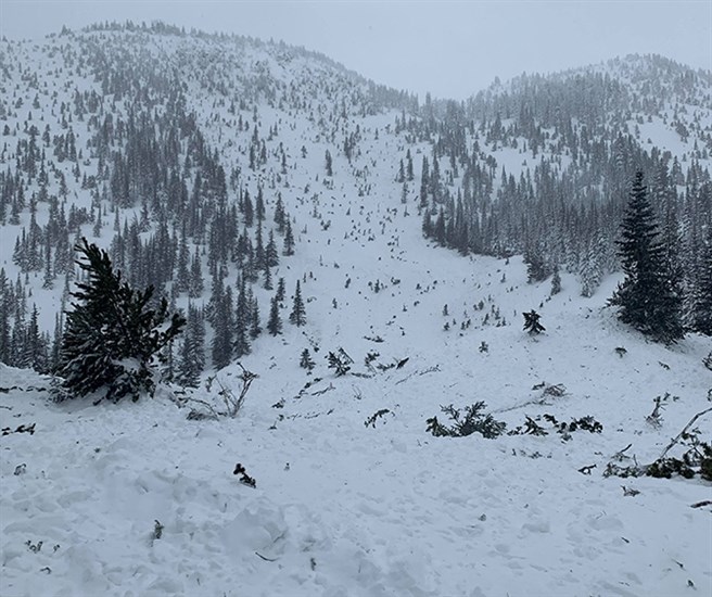
Avalanche Canada reports four large avalanches took place in the backcountry west of Penticton on the weekend, including one on Saturday, Feb. 8, 2020, that caught a group of sledders.
Image Credit: FACEBOOK / Samuel Johnson
February 10, 2020 - 6:00 PM
An unusual avalanche west of Penticton that nearly caught a group of snowmobilers owed its origins to the South Okanagan’s initial lack of snow this season.
Samuel Johnson posted his experience with the avalanche to the Avalanche Canada website on the weekend.
Johnson was part of a three-person snowmobile party in the backcountry near Apex Mountain Ski Resort on Saturday morning, Feb. 8, when an avalanche occurred while they were descending a gully.
Johnson said in a social media post he was partially buried and his sled buried when his airbag deployed. He described the avalanche as a class three, approximately 275 metres with a 500 m runout, details of which can be found on the Avalanche Canada website.
“I grew up riding in this area and have never seen an event like this,” Johnson posted to social media.
Avalanche Canada forecasting program supervisor James Floyer said it was “a little bit curious to notice a cycle of fairly large avalanches that occurred on Sunday.”
Avalanche Canada noted four significant slides in the Apex backcountry over the weekend.
“When you see a pattern like that, it’s a cause for concern. It was a complicated development of the snowpack this year in the South Okanagan. The season started in some places with very little snow, and the Apex area is included in those locations,” Floyer says.
Floyer says the group of locations that didn’t get snow initially gradually accumulated “very reasonable” amounts as the season progressed, but the early season lack of snow created a sugary bottom layer of faceted snow crystals that is a weak base.
He says photos of the avalanche indicate deep release scouring close to the ground, where movement occurred along that layer of early snow.
“It’s complicated because the further northeast and the further west you go, there aren’t those early season problems,” he says.
Floyer says the avalanche hazard at Apex was also compounded by the 60 to 70 centimetres of snow that fell in the higher terrain in the few days prior to Saturday, along with consistent winds.
“That was also consistent with rising avalanche danger,” he says.
Floyer believes the weekend avalanche cycle is a short-lived one.
“Most of the reason we saw that was all the new snow, combined with the winds. I would think we will unlikely see further avalanches,” he says.
A forecast calling for warm days and cool nights should also stabilize things, Floyer says.
“It’s always a good idea to be cautious, especially on steep slopes. We urge people to be cautious, and use their own observations in areas where forecasting might be limited. If in doubt, stick to lower angle territory,” Floyer says.
To contact a reporter for this story, email Steve Arstad or call 250-488-3065 or email the editor. You can also submit photos, videos or news tips to tips@infonews.ca and be entered to win a monthly prize draw.
We welcome your comments and opinions on our stories but play nice. We won't censor or delete comments unless they contain off-topic statements or links, unnecessary vulgarity, false facts, spam or obviously fake profiles. If you have any concerns about what you see in comments, email the editor in the link above.
News from © iNFOnews, 2020