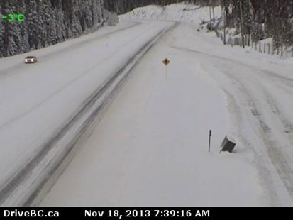
The Okanagan Connector saw a lot of snow late last week and will see more during the day and overnight, as will the rest of the mountain passes in the Southern Interior.
Image Credit: Drive B.C. webcam
November 18, 2013 - 10:12 AM
FIRST WEEK OF SUB-ZERO TEMPERATURES
THOMPSON-OKANAGAN – Much of the region can expect to see snow fall later today and overnight and yes, the snow level will even be to the valley bottoms for at least part of the day, and then temperatures below 0 Celsius will keep things on the wintery side for much of the week.
Around Kamloops, Salmon Arm and Vernon areas, a high of 3 C today will lead to highs of only -1 C Tuesday and in the more southern part of the region, Kelowna and Penticton, expect highs above 0 C but temperatures will drop to the minus end of the scale during the day Tuesday. The entire region will see temperatures drop three to six degrees during the day Tuesday as we dive head first into the cold snap.
Environment Canada says the temperatures will stay below 0 C through Saturday night in most areas though Sunday will also be well below seasonal normals of 3-4 C. After today, expect to see mostly sun throughout the region which should warm the heart if not the body.
Overnight lows will drop into the double digits starting Tuesday night in most communities. Normal lows at this time of year range from -3 C to -4 C.
Snow late last week and over the weekend hit some communities and mountain passes saw up to 40 cm of snow with more expected last night and today on the passes.
To contact a reporter for this story, email jstahn@infotelnews.ca, call (250)819-3723 or tweet @JennStahn.
News from © iNFOnews, 2013