
A recent photo of the Hope Slide, taken from a viewpoint just off Highway 3 around 14 kilometres east of Hope.
Image Credit: SUBMITTED / Scott McDougall
January 07, 2020 - 8:00 AM
The power of nature was unveiled in a deadly way to four motorists travelling the Hope Princeton Highway 55 years ago this week.
It was in early morning hours of Jan. 9, 1965 that a portion of a mountainside known as Johnson Peak in the Nicolum Mountains gave way, sending roughly 50 million cubic metres of rock and debris tumbling downslope, burying part of Highway 3 and killing four motorists in the process.
The Hope Slide, located east of Hope on Highway 3, is a tourist attraction of sorts today, with a viewing area just off Highway 3, built on the 55-metre high pile of debris that buried the original highway in 1965.
The slide compares in size to one that took place in 2010 on Mount Meager near Pemberton.
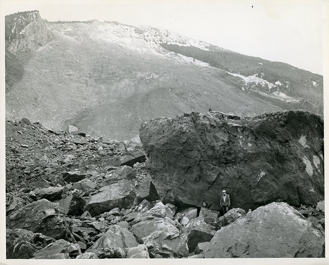
The Hope Slide, taken in 1965 from near the present day viewpoint off Highway 3.
Image Credit: SUBMITTED / Ministry of Transport
The Ministry of Highways and Infrastructure says four kilometres of highway was destroyed in the slide, which took 13 days to clear a roadway through.
The highway alignment was re-routed in the 1980s around the base of the debris field and a pull out and monument was created, dedicated to the event.
The ministry’s “Hope to Princeton B.C. Road Trip Time Machine" video, viewable below, shows scenes of the highway one year after the slide.
According to the open study book, “British Columbia in a Global Context”, the slide occurred around 7 a.m. Four motorists who were stopped on the highway because of an avalanche were swept up when the main event occurred and rocks tumbled 2,000 metres off the hillside.
The debris completely displaced water and mud in Outram Lake, throwing it against the opposite side of the valley and wiping out all vegetation, including trees, to bare rock.
According to excerpts from the Jan. 13 edition of the Hope Standard, as reported in the Hope Standard in the Jan.18, 2018 edition, a search party uncovered the bodies of Bernie Lloyd Beck, 27, of Penticton, and Thomas Starchuk, 39 of Aldergrove after an extensive search of the debris.
The bodies of the other two victims, Mary Kalmakoff, 23 and Dennis Arlitt, 23, both of Penticton, were not found.
University of B.C. Department of Earth, Ocean and Atmospheric Sciences assistant professor Scott McDougall says the amount of rock displaced in the avalanche could fill B.C. Place Stadium 20 times over.
“It’s an interesting site. It may be the largest historical landslide in Canadian history,” he says.
McDougall says early theories postulated heavy rainfall collecting in groundwater under the mountain built up pressure to the point where the surface let go, but the area had been under cold winter conditions for the past weeks.
“It most likely wasn’t that, but it could have been triggered by freezing of water on the surface that blocked outlets for ground water exiting the slope,” he said.
The mountainside also contained pre-existing faults and shear zones that increased its instability.
McDougall says information at the viewpoint on Highway 3 says the four victims were stopped by an initial snow avalanche on the highway.
“The original thinking was there were two earthquakes of small magnitude that triggered the slope failure, but more modern thinking is those earthquakes were actually signatures of the slide moving across the valley floor. It’s easy to see how a huge slide of rocks travelling downslope could trigger a seismograph,” he says.
Simon Fraser University research assistant Davide Donati agrees the slide caused the earthquakes measured around the time of the slide, rather than the slide being caused by earthquakes.
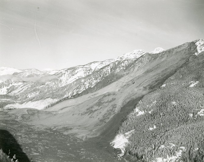
A view of the valley floor taken shortly after the Hope Slide in 1965. Highway 3 is completely obliterated.
Image Credit: SUBMITTED / B.C. Ministry of Transportation and Infrastructure
Could such an event happen again?
McDougall says evidence exists at the site of a previous, prehistoric failure of nearly equal proportion several thousand years ago.
“Two large avalanches have happened at that location, so lightning can strike twice,” he says of the possibility of future slides.
He says a case study has been done in recent years along adjacent slopes, as conditions at the Hope Slide extend further along the valley.
“There are similar slope conditions but orientation of the rock may change with distance from that location. It’s not a sure thing the same conditions exist, but the possibility of another failure can’t be ruled out,” he says.
It's probably not something that should occupy too much of your imagination the next time you make a trip to or from the coast on any of B.C.’s highways.
“There are probably more slides that have occurred in B.C. than we realize. Maybe not on a human time scale, but from a geological one,” he says.
Donati says the initial rockslide took place at the end of glaciation, about 10,000 years ago.
He says that failure set the scene for the 1965 event, causing a slow deformation of the slope. He says the ‘trigger' for the 1965 event remains unclear, but could possibly be one of “progressive failure” as the slope gradually became weaker with time.
“Wherever we have steep slopes, we can expect land sliding,” Donati says.
He says landslides do provide warnings.
“Deformation ‘signs’ can be observed, such as cracks, fractures and scarps, which progressively open up. Smaller events such as rockfalls tend to increase in frequency before a major event, and once recognized, can be tracked,” he says. "The challenge is know where to look."
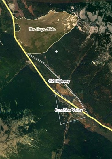
The Hope Slide is located a few kilometres west of Sunshine Valley on Highway 3, about 14 kilometres east of Hope.
Image Credit: SUBMITTED / B.C. Ministry of Transportation and Infrastructure
Hope to Princeton time machine
To contact a reporter for this story, email Steve Arstad or call 250-488-3065 or email the editor. You can also submit photos, videos or news tips to tips@infonews.ca and be entered to win a monthly prize draw.
We welcome your comments and opinions on our stories but play nice. We won't censor or delete comments unless they contain off-topic statements or links, unnecessary vulgarity, false facts, spam or obviously fake profiles. If you have any concerns about what you see in comments, email the editor in the link above.
News from © iNFOnews, 2020