
The smoke forecast for tomorrow, Sept. 13.
Image Credit: BC Asthma Map
September 12, 2020 - 10:55 AM
Smoke from what have been called “climate fires” in the northwestern United States is seeping into B.C. and depending on where you are the situation looks like it will range from bad to worse.
Environment Canada issued a special air quality statement for the South Thompson, Nicola, Similkameen, Okanagan Valley, Shuswap, Boundary, and North Thompson, saying that smoke is going to be an issue for the next 24 to 72 hours at least. There are also alerts for more northern areas of the province and the Lower Mainland for what the national meteorological agency said will be a “significant push of smoke into B.C.”
“The anticipated smoke trajectory indicates that the areas impacted will grow to the north and east as the weekend progresses with the most widespread impacts expected on Sunday,” Environment Canada said in the alert.
“Areas at higher latitudes, such as Prince George, may have smoke passing through the region aloft. With falling temperatures overnight, temperature inversions in mountain valleys can increase the likelihood of smoke being trapped near the ground.”
To get a better idea of how much smoke will be where, the BC Asthma Prediction System offers an interactive map that forecasts the concentration of particulate matter and predicts an asthma-related health risk when there’s an abundance of wildfire smoke.
Using a PM2.5 reading, which refers to atmospheric particulate matter with a diameter of fewer than 2.5 micrometers, they show which areas will have the most toxic air.
These fine particles tend to stay longer in the air than heavier particles which increases the chances of inhalation, penetrating deep into the lungs.
The map indicates that the worst day will be Sunday, and the rating for PM 2.5 for the Okanagan will be high, with 50 to 100 PM 2.5. Kamloops and the Shuswap are expected to fare better with a 25 to 50 PM 2.5 level.
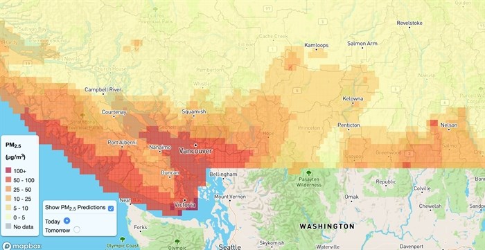
The air quality for today, Sept. 12, according to the BC Asthma Map.
Image Credit: BC Asthma Map
The Lower Mainland is the worst off, though, with a 100 plus level. It’s already had several bad days of smoke, and on a site called IQ Air Vancouver currently has been rated as the worst air quality in the world, next to Portland.
The fires have taken a toll on Washington, California and Oregon.
At a news conference on Friday, Gov. Jay Inslee said the fires shouldn’t be called wildfires, but “climate fires.”
“This is not an act of God,” Inslee said. “This has happened because we have changed the climate of the state of Washington in dramatic ways.”
To contact a reporter for this story, email Kathy Michaels or call 250-718-0428 or email the editor. You can also submit photos, videos or news tips to the newsroom and be entered to win a monthly prize draw.
We welcome your comments and opinions on our stories but play nice. We won't censor or delete comments unless they contain off-topic statements or links, unnecessary vulgarity, false facts, spam or obviously fake profiles. If you have any concerns about what you see in comments, email the editor in the link above.
News from © iNFOnews, 2020