
A rainbow is pictured over Skaha Lake in the South Okanagan in this file photo.
(STEVE ARSTAD / iNFOnews.ca)
September 17, 2019 - 7:00 AM
KAMLOOPS - Warmer than usual temperatures and more rainfall than normal in September in Kamloops and the Okanagan could be attributed to a warm patch in the Pacific Ocean known as The Blob.
Environment Canada meteorologist Matt MacDonald says an area of the ocean off the B.C. coast is affecting temperatures and precipitation.
“Some people are calling this the return of The Blob. It's a huge chunk of water in the Pacific that’s warmer than normal and that warm water injects the atmosphere with some heat,” he says.
MacDonald says the warmer patch of the ocean was named The Blob when it was first noticed in 2013 and it has recently reappeared. MacDonald says it could be the reason why this September has been warmer and wetter than usual.
“We've seen some really mild nights from the South Thompson down through the Okanagan... part of it is due to the temperature of the Pacific Ocean right now,” he says.
A Twitter user who follows the weather in Kamloops closely recently stated a record had been broken for the longest consecutive days with lows above 10 C, as well as records set for consecutive rainy days. MacDonald could not verify the records but agreed it has been a wetter, warmer month than previous years.
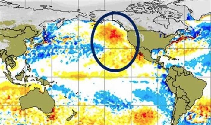
This image shows The Blob in 2014 when a warm patch of water caused changes to the weather on the Noth American coast.
Image Credit: The Weather Network
“If I look back at the overnight lows, they have all indeed been significantly warmer than normal,” MacDonald says. “It started higher than normal and if we work out way through the month, on Sept. 15, the average overnight low (for Kamloops) is 8.6 degrees and last night we went to 12.9 degrees. Much warmer than normal at nighttime.”
MacDonald says the increased cloud cover could be part of the reason for warmer nights.
“It’s been cloudier than normal. When we have clouds at night it kinds of acts like a blanket to keep heat in. Clear nights tend to be cooler but when we have cloud overhead it tends to lock in that heat,” he says.
The Blob can be credited in part for keeping the nights warmer than usual, but can also be part of the reason for higher rainfall rates across the region.
“Because of the heat in the ocean, it increases the temperature of the atmosphere and a warmer atmosphere can hold more water vapour, so it slightly increases the chance of seeing more rain,” MacDonald says.
This month has seen higher than average rainfalls around the region, with areas of the Thompson-Okanagan exceeding the average amount of rainfall for this time of year.
“It has been a pretty wet start to the month,” MacDonald says. “So far the airport in Kamloops has picked up 19.4 mm, and the historical average for Sept. is 29.4 mm, so despite being halfway through the month, we've seen about two-thirds of the normal amount of rain.”
Kelowna has already had 24.4 mm of rain, and the average amount for Sept. is 32.4 mm.
MacDonald says Vernon is usually the wettest of the South Thomspon-Okanagan cities, with September averaging about 40.8 mm of precipitation. Vernon has already seen 32.1 mm of rain, more than three-quarters of the average amount. It hasn’t been the wettest city, though.
“Penticton has been the wettest compared to normal,” MacDonald says. “They picked up 34.8 mm and their normal for the month is 24.6 mm, so they've already exceeded the average amount of rain for September and it’s only mid-month.”
The start of the month has brought about some of the strongest thunderstorms of the summer. MacDonald says Sept. 7 was the most active day for lightning strikes in the region, hitting the Kelowna area with 1,164 strikes and more than 2,500 lightning strikes within 50 kilometres of Kamloops. On Sept. 3 the second most active lightning storm hit the area, with 750 strikes near Kamloops and nearly 1,100 strikes near Kelowna.
“We've seen quite an active storm pattern over the past week and a half with back to back systems coming in across the coast one after the other. Typically when these systems aren't all that strong, they'll fizzle out on the coastal side of the coastal range but when they have a little more oomph to them, they can carry over the coastal mountain range,” MacDonald says.
Although it has been a wet start to the fall season, MacDonald says the forecast for September, October and November are all expected to show higher than normal temperatures.
“The Return of The Blob can have pretty major impacts,” MacDonald says. “From a weather perspective, our seasonal forecast here is showing a strong probability of a warmer than normal fall.”
To contact a reporter for this story, email Jenna Wheeler or call (250) 819-6089 or email the editor. You can also submit photos, videos or news tips to the newsroom and be entered to win a monthly prize draw.
We welcome your comments and opinions on our stories but play nice. We won't censor or delete comments unless they contain off-topic statements or links, unnecessary vulgarity, false facts, spam or obviously fake profiles. If you have any concerns about what you see in comments, email the editor in the link above.
News from © iNFOnews, 2019