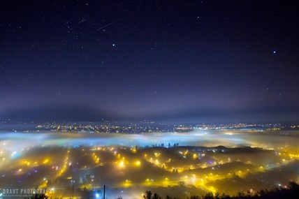
The view of Vernon from Turtle Mountain on Tuesday, Dec. 16, 2014.
Image Credit: Draht Photography
December 22, 2014 - 2:29 PM
VERNON - It’s beginning to look a lot like Fog-ville.
The Vernon and Armstrong areas have been socked in with low-lying fog on and off for days, leaving the region cloaked in the wrong kind of white stuff for the holidays. So what’s causing the stubborn fog, and when will it be on its merry way?
The valley is always prone to fog, but Environment Canada meteorologist Doug Lundquist says several factors are making it hang around longer than usual. Fog is created when warm temperatures hover above the cold snow on the Monashee Mountains. Usually, that fog lifts into low lying cloud in fairly short order, but recently, Lundquist says cold temperatures locked in the moisture, trapping mist in the valley.
Now we either need wind or a cold front to blast the fog out of the valley. According to Lundquist, it’s looking like we’ll get one of the two from Mother Nature in time for Christmas.
An Arctic front is predicted to move in on Christmas Eve which should clear up the fog for Dec. 25. It remains to be seen if we’ll get a dump of the white stuff for Christmas.
Lundquist says the type of persistent fog currently settled in the North Okanagan is what we typically see in the fall, not the winter.
“It’s a really unusual pattern,” he says.
In the meantime, a Vernon photographer has been making the most of the valley fog.
To contact the reporter for this story, email Charlotte Helston at chelston@infonews.ca or call 250-309-5230. To contact the editor, email mjones@infonews.ca or call 250-718-2724.
News from © iNFOnews, 2014