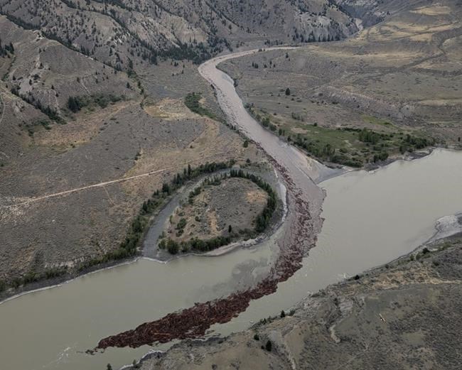
Debris is seen flowing down the Chilcotin River and into the Fraser River following a landslide near Williams Lake, B.C., in a Monday, Aug. 5, 2024, handout photo. bridge over British Columbia's Chilcotin River is closed to traffic until further notice after new cracks were discovered near where a massive landslide blocked river flow for almost one week before a breach sent torrents of water and debris downstream to the Fraser River. THE CANADIAN PRESS/HO-Tsilhqot'in National Government, *MANDATORY CREDIT*
Republished August 12, 2024 - 3:21 PM
Original Publication Date August 09, 2024 - 2:41 PM
WILLIAMS LAKE, B.C. - A bridge over British Columbia's Chilcotin River was closed to traffic Friday after new cracks were discovered along the hillside near a massive landslide that had blocked the river for days before a breach sent torrents of water and debris downstream.
The bridge at Farwell Canyon on Farwell Canyon Road south of Williams Lake was closed due to concerns for public safety, the Tsilhqot'in National Government said in a notice posted on social media.
The notice included two photos showing what appeared to be large and lengthy cracks in the landscape above the river, and a statement saying the nation has placed security officials at the bridge.
"The province is currently assessing these cracks," said the Tsilhqot'in statement. "Due to concern for public safety, the bridge will be closed until further notice."
Chief Joe Alphonse, Tsilhqot'in National Government tribal chair, and Nathan Cullen, B.C.'s water, land and resource stewardship minister, said Thursday there were concerns about future slides and unstable banks along the river near the landslide site.
Alphonse said there were concerns that rainfall could trigger new slides.
Environment Canada's weather forecast for the coming week at Williams Lake shows the chance of daily rain showers from 30 per cent to 60 per cent from Saturday to Thursday.
The landslide dammed the Chilcotin River last week before breaking free on Monday, sending water, trees and debris downstream into the connecting Fraser River, which flows through the Lower Mainland to Georgia Strait.
Flood advisories along both the Fraser and Chilcotin rivers were lifted Thursday as flows returned to normal levels, said Connie Chapman, B.C. water management branch executive director.
Local First Nations, B.C. government and Fisheries Department officials say they are also trying to assess the slide's potential impact on migrating salmon, but the area remains too unstable at the moment.
Alphonse and Cullen said the Chilcotin River appears to have carved new paths after the landslide that could make it difficult for migrating salmon heading to upstream spawning areas.
Cullen said plans are already underway to assist salmon through a difficult bottleneck area created by the raging river after the landslide, but government officials and Indigenous leaders are waiting to see if the choke point will clear itself in the coming days.
A massive rock slide in 2019 on the Fraser River at Big Bar, downstream from the Chilcotin River, saw officials catch and transport salmon past the site to continue their migration.
First Nations across B.C. are also concerned about the slide's possible impact on migrating salmon, said Bob Chamberlin, First Nations Wild Salmon Alliance chairman.
"It's been said to me that 90 per cent of all First Nations in B.C. rely on salmon," he said in an interview. "When you take a look at how many nations are on the Fraser River, the challenges that nature's introducing are huge."
Chamberlin said every effort must be made to ensure the Chilcotin River salmon can make it to spawning grounds.
The Fisheries Department said in a statement Friday it is working with First Nations and the B.C. government to assess the potential effects of the slide on salmon.
"The Chilcotin River is a major tributary to the Fraser River and supports populations of early timed chinook, early summer sockeye, summer run sockeye, Interior Fraser coho and steelhead, several of which are stocks of conservation concern," said the statement. "Due to the current high sediment load and decrease in water quality, adult chinook and sockeye salmon in the Chilcotin system have only been observed upstream of the slide."
The department said the majority of adult sockeye salmon are expected to arrive at the confluence of the Chilcotin and Fraser rivers around the third week in August. ?
Adult coho salmon migrate into the Fraser River watershed in early fall and are not expected to arrive in the Chilcotin River area until mid-September, said the statement.
"At this point, the site is not safe to access and it is too early to determine what measures may be required or possible," the department said. "Actions to?address impacts to salmon habitat will depend on the scope?of?effects, once known, and will be undertaken?in collaboration?with local First Nations and?the Province of B.C., once it is safe to do so."
— By Dirk Meissner in Victoria
This report by The Canadian Press was first published Aug. 9, 2024.
Note to readers: This is a corrected story. A previous version said the bridge at Farwell Canyon is on Highway 20. In fact the bridge is on Farwell Canyon Road.
News from © The Canadian Press, 2024