
Kal Beach on Kalamalka Lake in Coldstream is pictured in this file photo.
(CHARLOTTE HELSTON / iNFOnews.ca)
July 28, 2022 - 7:30 AM
The hottest day of this summer’s heat wave should be today, July 28, in Kamloops, the Okanagan and much of B.C.
But don’t expect it to cool down appreciably until after the weekend. And, since this is a long weekend, even Monday is going to be hot.
By Tuesday, however, clouds, rain and below 30 Celsius temperatures are predicted by Environment Canada’s online forecast.
Lytton, as usual, will get some of the highest temperatures with 42 C forecast for today, followed by 41 C on Friday and Saturday.
Kamloops is not far behind with 40 C forecast today, dropping to 36-38 C through the weekend.
Kelowna and Vernon are showing highs of 38 C today, dropping to 37 C through the weekend. The forecast is for a degree or two cooler in the South Okanagan.
After the weekend, relief appears to be on the way.
Cloudy skies with a high of 27 C are forecast for Kamloops on Tuesday with a 60% chance of showers Wednesday.
The Okanagan forecast for the showers to hit on Tuesday, with highs of 27 C then dropping a couple of degrees on Wednesday, again with a 60% chance of showers.
Environment Canada’s forecast only goes through to Wednesday of next week. AccuWeather, which has longer range forecasts, shows it drying up by Thursday then returning to sunny skies after that, although it’s showing high temperatures only in the low 30s.
That means, for heat lovers, today is the day to enjoy it.
But, the Environment Canada heat warning continues so people need to be cautious about overheating.
READ MORE: What workers can legally do avoid unsafe work in heatwave
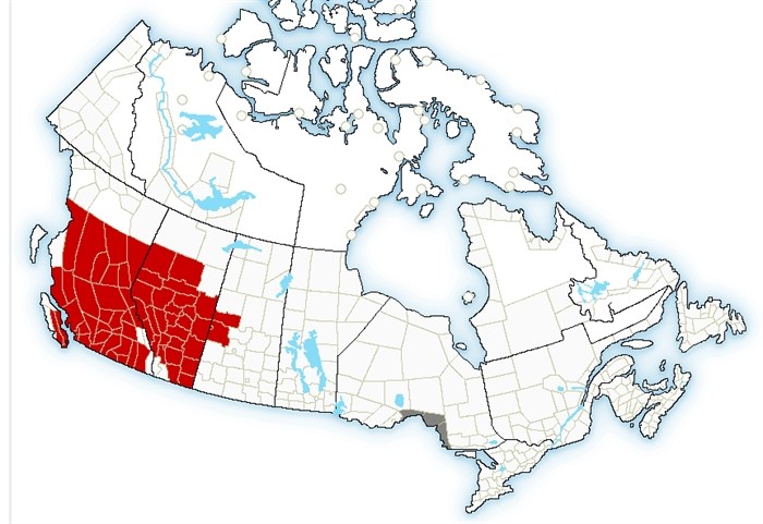
This map shows the extent of the heat warnings, in red, issued by Environment Canada.
Image Credit: Submitted/Environment Canada
Cooling centres have been set up in most regional cities and care agencies are busy distributing water and other cooling essentials to vulnerable people on their streets.
READ MORE: Kelowna man delivering water, popsicles to homeless people as mercury soars
The heat warning covers most of Central and Southern B.C. and Alberta and extends into central Saskatchewan.
The heat is not penetrating into Eastern Canada just yet with a 60% chance of showers forecast for Toronto with a high of 28 C today. That’s expected to turn to sunshine by Saturday but temperatures are still forecast to only be in the high 20s.
That pattern is similar for much of Eastern Canada, including the Maritimes, although it will be cooler on the East Coast and St. John’s NL is looking at highs only in the low 20s.
To contact a reporter for this story, email Rob Munro or call 250-808-0143 or email the editor. You can also submit photos, videos or news tips to the newsroom and be entered to win a monthly prize draw.
We welcome your comments and opinions on our stories but play nice. We won't censor or delete comments unless they contain off-topic statements or links, unnecessary vulgarity, false facts, spam or obviously fake profiles. If you have any concerns about what you see in comments, email the editor in the link above.
News from © iNFOnews, 2022