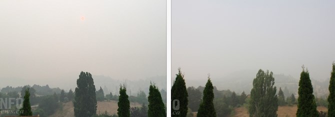
The left photo was taken in Penticton in 2018 and the right photo today, Sept. 15
(STEVE ARSTAD / iNFOnews.ca)
September 15, 2020 - 5:30 PM
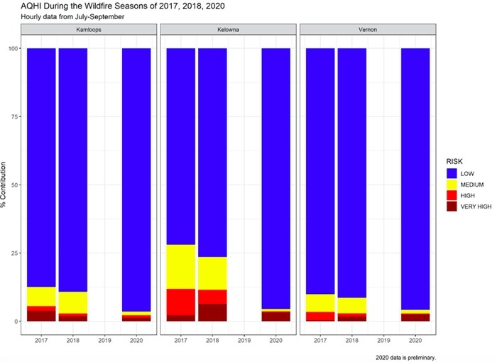
While eyes may be stinging and throats are scratchy, this year’s air quality has not hit the levels seen in the peak forest fire years of 2017 and 2018.
And, determining which was the worst year depends on where you live. For Kamloops it was 2017. For the Okanagan it was 2018.
Right now, readings in much of the region are off the Air Quality Health Index scale of one to 10 at 10 + indicating the risk to health is very high.
“If it’s 10+ that just means that the air quality is as bad as you can expect it to be,” Trina Orchard, air quality meteorologist with the Ministry of Environment told iNFOnews.ca. “While concentrations can increase, it’s just terrible, terrible air quality.”
READ MORE: U.S. wildfire smoke pushes Okanagan air quality readings off the scale; Kamloops close behind
The Ministry’s website for its Air Quality Health Index tops out at 10+ but the more detailed numbers are still tracked.
So far this year, Kamloops’ highest reading only hit 15. In 2017, Kamloops reached 87 under a thick blanket of smoke from nearby fires, predominantly the Elephant Hill fire, the worst in recorded B.C. history.
Orchard did stress, however, that the 2020 numbers are preliminary so may be subject to errors.
Kelowna has the worst Air Quality Health Index reading this year at 30 but peaked at 46 in 2018.
Vernon came in at 27 this year versus 37 in 2018. No data was provided on this measure for Penticton.

Image Credit: Submitted/Ministry of Environment
That index tracks a number of factors that have an impact on health.
Another way of looking at air quality is to measure fine particulate matter, identified as PM2.5 and measured in micrograms per cubic metre. Any reading over 25 is considered worthy of an advisory being issued.
That can be viewed, here, by the hour or as a 24-hour average.
At about 10:30 this morning, Vernon was at 232 micrograms per cubic metre over the previous 24 hours, Penticton was at 221.3, Kelowna 207.7 and Kamloops at a lowly 85.9. Grand Forks, on the other hand, was sitting at 309.3.
By this afternoon, most of those readings had dropped slightly but that’s not likely to last.
“Some clean air over the Central Interior has moved down into the Kamloops area, which is clearing the air up in that city today,” Environment Canada meteorologist Doug Lundquist said. “That cleaner air is trying to filter down this way, but it’s only temporary and I don’t think it will make it down to Penticton, possibly not below Vernon.”
READ MORE: Improving smoke levels in Kamloops, Okanagan are only temporary
Despite whatever numbers are used, the reality is that smoke impacts different people in different ways and not all forest fire smoke is the same, Orchard said.
“Some of the smoke that is travelling now is from aloft,” Orchard said. “Smoke does change form over time. You lose some of the big particles. You keep some of the really small particles.
“Smoke that’s (transported over long range) can look different. It can smell different. It also depends on what was in the smoke, what was burned. Some of the smoke from the States is coming from entire houses that are on fire. So the composition of the smoke is different. It might smell different, say, from a forest fire burning pine trees.”
She noted that there’s one big chemical fire in the U.S. but she doesn’t think its smoke is making its way to the Okanagan.
To contact a reporter for this story, email Rob Munro or call 250-808-0143 or email the editor. You can also submit photos, videos or news tips to the newsroom and be entered to win a monthly prize draw.
We welcome your comments and opinions on our stories but play nice. We won't censor or delete comments unless they contain off-topic statements or links, unnecessary vulgarity, false facts, spam or obviously fake profiles. If you have any concerns about what you see in comments, email the editor in the link above.
News from © iNFOnews, 2020