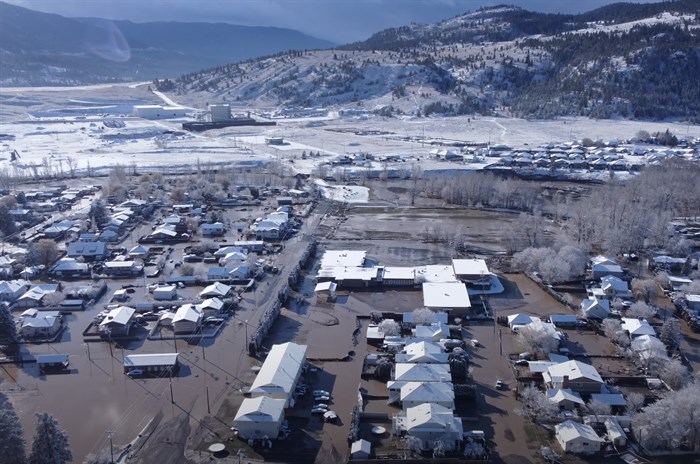
The Coldwater River, which flooded parts of Merritt, is expected to get more water runoff from another atmospheric river later this week.
Image Credit: YOUTUBE/Greg InBC
November 22, 2021 - 2:37 PM
Another atmospheric river hitting the Lower Mainland on Thursday is going to have a follow-through impact on flooded cities like Hope and Princeton.
It’s expected to dump 40 to 70 millimetres of rain in the Fraser Valley on Thursday. Another system will follow Saturday through Sunday.
It’s too early to predict how much precipitation will come with the second system, Climate Change Canada’s warning preparedness meteorologist Armel Castellan said during a news briefing today, Nov. 22.
The atmospheric river won’t hit flooded areas like Merritt or Princeton too hard in terms of direct rainfall but, with the freezing temperature rising to 2,500 metres, what rain that does fall will help melt snow that’s expected to accumulate to as much as 30 centimetres between Hope and Merritt overnight tonight and into tomorrow.
“With the freezing levels going up so high and cycling though, with precipitation that’s mostly on the windward side, those will likely exacerbate snowmelts and conditions in the Coldwater River,” Castellan said.
The Coldwater River flooded Merritt and changed its channel. Efforts are planned to reroute it.
READ MORE: Merritt to use massive 170 m blow-up dam to temporarily move river back after flood
He didn't comment on the impact the snow and rain and melting might have on the Tulameen River that flooded Princeton.
There have been a series of atmospheric rivers this fall, which are normal at this time of year. It’s just that the ground has been saturated by the frequency and intensity of the rainfall since early September, Castellan said. Many parts of the Lower Mainland and Southern Interior have experienced rainfall at 200% of normal levels.
Wildfires also have an impact on how hills absorb moisture. He can’t forecast what the storms this week will do on the ground but noted numerous slides on Highway 1 between Cache Creek and Kamloops were aided by the 2017 Elephant Hill forest fire.
While Thursday’s atmospheric river doesn’t look to be as big as the one that caused the flooding and highway washouts last week, he said, it’s too early to predict what will happen with the next one on Saturday or others that are sure to follow.
“We are dealing with very active weather for the foreseeable future,” Castellan said.
To contact a reporter for this story, email Rob Munro or call 250-808-0143 or email the editor. You can also submit photos, videos or news tips to the newsroom and be entered to win a monthly prize draw.
We welcome your comments and opinions on our stories but play nice. We won't censor or delete comments unless they contain off-topic statements or links, unnecessary vulgarity, false facts, spam or obviously fake profiles. If you have any concerns about what you see in comments, email the editor in the link above.
News from © iNFOnews, 2021