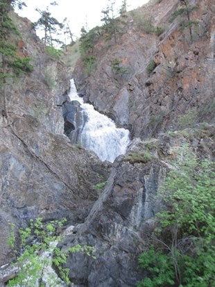
The city is warning people to stay away from Peterson Creek, one of several creeks that is seeing high water levels right now.
Image Credit: Anthony Stahn
May 12, 2014 - 1:11 PM
KAMLOOPS - Rising and rushing water has the city asking people to be careful near smaller tributaries as well as near ditches and culverts.
Peterson, Tranquille and Campbell creeks are among the creeks already affected by high water flow and this fast moving water not only makes the water unsafe, it also can cause the banks to be unstable.
“They’re definitely swollen right now,” Kamloops Fire Rescue Chief Communications Dan Sutherland says. “Stay away from them, it’s very cold water and really flowing at rapid rates.”
River levels for the North and South Thompson rivers are below even the 50 per cent chance of minor flooding level and the snow basins currently sit at near normal, or just slightly above that mark.
The Thompson River at Kamloops sits at 4.16 m as of this morning, a level it has sat at for about a week except for a small spike on Thursday before receding back to 4.16 m. The South Thompson River, at Chase, currently has a flow rate of 395 cubic metres per second, well below the 50 per cent minor flood level (called the two year rate) of 958 cubic metres per second.
The North Thompson snow basin was at 102 per cent as of the beginning of May, up from 91 per cent in March, while the South Thompson snow basin was at 114 per cent, up from 100 per cent just two months ago. This increase is in part attributed to a slight delay in the onset of the melt season.
Sutherland notes while the snow pack levels are not indicative of what will happen with river levels, there is a very small increased risk with the higher snow pack.
“The freshet has just begun, it’s still very early in the season,” he notes. “The mid-elevation snow pack is melting at a good rate, we expect it to be almost gone in the next week or two leaving just the high-elevation snow pack.”
The River Forecast Centre notes warm weather this month has led to the ‘ripening of the snow at mid-to-high elevations’ which puts most basins at risk for flood if adverse weather, like heavy rains or above normal temperatures, occurs. This risk could continue through late June to early July.
In Kamloops the fire department is asking people to keep pets on leash and away from water and to avoid all streams and water bodies with rising levels. Awareness around ditches and culverts is also needed and the city asks anyone who comes across a blocked or obstructed culvert or ditch to contact public works at 250-828-3461.
Sutherland adds the city does have a freshet watch team of experts working within the city and participate in weekly coordination calls with Emergency Management B.C., the River Forecast Centre and Environment Canada.
“We have a pretty darn good idea what will happen in the next 5-6 days and we go over any risks or action items,” he says, adding, “The flow rate over the next week is predicted to remain stable.”
For those looking to get out on their boats over the long weekend Sutherland reminds them to exercise caution and be aware of the extra debris that floats in the river at this time of year.
To contact a reporter for this story, email Jennifer Stahn at jstahn@infotelnews.ca or call 250-819-3723. To contact an editor, email mjones@infotelnews.ca or call 250-718-2724.
News from © iNFOnews, 2014