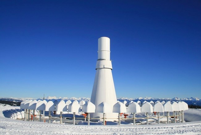
This was the world's first underground radio range when it was built in the early 1960's in the North Okanagan.
Image Credit: Submitted/Enderby and District Museum and Archives
January 29, 2023 - 7:00 AM
A little-known navigational aid for airplanes near Enderby, in the North Okanagan, has served its purpose and is awaiting demolition.
Built in the early 1960s for $200,000 the very high frequency omni-directional range (VOR) and tactical air navigation (TACAN) station sits on and in the top of Hunters Range.
That’s according to a Sept. 15, 1961 article in the Enderby Commoner that was posted recently on the Enderby and District Museum and Archives Facebook page.
“By next year, aircraft on the Edmonton-Vancouver airway will be guided by the world’s first underground radio range, set in the top of a mountain, the Department of Transport announced last weekend,” the article says.
The plan was to complete the station in 1962.
“The equipment that is to be housed in the station calls for a round, flat unobstructed platform 300 feet in diameter,” the newspaper article says. “Rather than extending the building’s flat roof to that size, the department found it will be cheaper to shear the peak off the mountain and bury the station beneath it.”
It refers to the station as a 12-sided concrete structure with a diameter of 52 feet (16 metres).
The hill, which the newspaper said is the highest in the region, is 25 km northwest of Enderby and rises to a height 7,000 feet (2,134 metres).
The station was unmanned with a technician visiting it periodically. Overnight shelter was provided on site.
The station provided “point-to-point guidance information or position data to aircraft in flight,” an email from Nav Canada to iNFOnews.ca explains.
It provided 360-degree views of the airspace but was limited based on line-of-sight obstructions, such as mountains.
That’s why it was built on top of a mountain. But that made accessibility for maintenance challenging, the Nav Canada email says.
The newspaper says the mountain gets 12 to 15 feet (3.5 to 4.6 metres) of snow each year.
The TACAN (tactical air navigation) part of the station provided information to military aircraft. TACAN stations were often combined with the high frequency omni-directional range (VOR) stations across the country.
“Over time, reliance on this VOR decreased based on the proliferation of GPS navigation and other existing infrastructure,” the email says.
“Nav Canada decommissioned the Enderby VOR on February 25, 2021, which means it was turned off, removed from aeronautical publications and is no longer used for navigation purposes. The hardware will be dismantled and removed from the land in the future.”
The email did not say when that removal will happen.
To contact a reporter for this story, email Rob Munro or call 250-808-0143 or email the editor. You can also submit photos, videos or news tips to the newsroom and be entered to win a monthly prize draw.
We welcome your comments and opinions on our stories but play nice. We won't censor or delete comments unless they contain off-topic statements or links, unnecessary vulgarity, false facts, spam or obviously fake profiles. If you have any concerns about what you see in comments, email the editor in the link above.
News from © iNFOnews, 2023