
Kamloops and the Okanagan have enjoyed some of the finest weather in the country so far this spring, but the summer forecast from the Weather Network could bring some unwanted side effects.
(STEVE ARSTAD / iNFOnews.ca)
May 29, 2019 - 6:00 AM
The Weather Channel has released its Canadian summer weather forecast with a prediction of weather patterns heading our way with the potential to bring some good, bad and downright ugly conditions to Kamloops and the Okanagan this year.
The Good
If you love the heat in the summer, you’ll appreciate this part of the forecast.
Weather Channel meteorologist Kelly Sonnenburg says temperature-wise, Kamloops and the Okanagan should trend above normal for the summer season.
“You’ve had a taste of that already. B.C and the Yukon were the only two regions of the country that recorded temperatures above seasonal in May. Everywhere else was cooler and unsettled,” Sonnenburg said from her office in Oakville, Ontario today, May 28, where it was 9 Celsius, windy and drizzly.
Sonnenburg says the first week in June is expected to be unsettled and unseasonably cooler in Kamloops and the Okanagan, which normally has high temperatures around 22 C.
She says the early June temperatures won’t be a prelude to what the rest of the summer has in store, however, when a ridge of high pressure is expected to dominate, bringing above seasonal temperatures for the rest of June, and into July and August.
The Bad
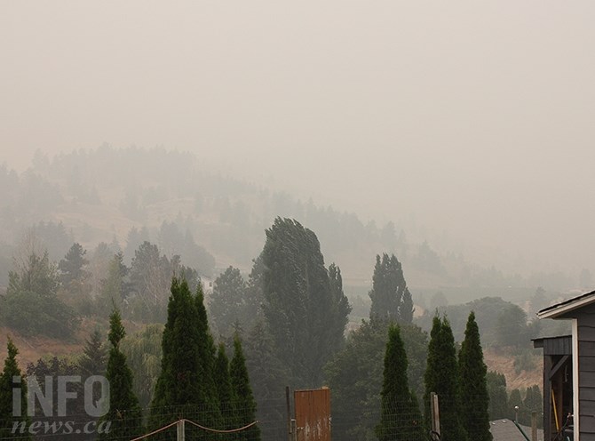
A stagnant high pressure ridge over the Okanagan last summer was responsible for some very smoky days.
(STEVE ARSTAD / iNFOnews.ca)
The problem with high pressure ridges, says Sonnenburg, is they tend to be prime weather patterns for bringing sinking air in to the B.C. Interior. Smoke from wildfires burning in the province becomes trapped in these conditions, and the Okanagan in particular is a prime location for trapping smoke.
Remember last August?
“It’s going to be problematic this summer season, with more stagnant air masses in place, which is what high pressure ridges produce,” she says. “If you have smoke in your locality, you’re likely to have it for days.”
Smoke can also have a repressive effect on temperatures.
“From a meteorological point of view, smoke really has to be considered when it’s in the area, it can factor greatly into temperatures,” Sonnenburg says.
The Ugly
All that predicted hot and sunny weather will put precipitation at a premium.
Sonnenburg says rain is difficult to predict in the summer, when a localized thundershower might drop 30 mm in one location, and 30 km away it’s still dry.
“We are looking at a quieter pattern with below normal precipitation,” she cautions.
“It’s not an ideal forecast for low wildfire activity. The high pressure expected to dominate doesn’t allow weather systems to move onto the B.C. coast, and it pumps heat into the B.C. Interior, creating dry conditions and more wildfire concern.”
To contact a reporter for this story, email Steve Arstad or call 250-488-3065 or email the editor. You can also submit photos, videos or news tips to the newsroom and be entered to win a monthly prize draw.
We welcome your comments and opinions on our stories but play nice. We won't censor or delete comments unless they contain off-topic statements or links, unnecessary vulgarity, false facts, spam or obviously fake profiles. If you have any concerns about what you see in comments, email the editor in the link above.
News from © iNFOnews, 2019