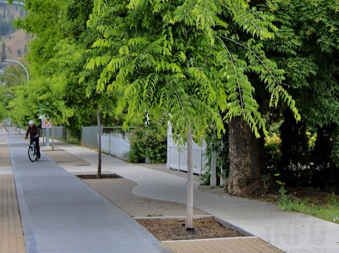
Future bike paths in Kelowna aren't likely to be as fancy as this section on Ethel Street.
(ROB MUNRO / iNFOnews.ca)
June 10, 2019 - 4:00 PM
KELOWNA - Don’t expect to cycle on the “gold standard” of bike paths that run along Ethel Street in downtown Kelowna as the city’s bike network steadily grows.
With forecast spending of $46.3 million over 10 years, cyclists will be able to travel almost from Mission Creek do downtown Kelowna protected from traffic.
The city is becoming smarter and more cost effective in the way it designs and builds these bike paths, Matt Worona, the city’s Active Transportation Coordinator, told iNFOnews.ca.
“When we were first doing this, we were kind of building the gold standard,” he said. “Now we’re looking at things that are sort of ‘nice to haves.’ As we continue the (Ethel Street) project, we’re looking at much lower costs.”
The Ethel Street bike paths were built as raised paths next to sidewalks with landscaping features on both sides of the road from Cawston Avenue to Sutherland Avenue at a cost of about $5,000 a metre.
A similar pathway, to be built this year along Sutherland from Lake Avenue to Burtch Road, will be built only on one side of the street, cutting the cost in half, Worona said.
And future sections of Ethel will likely be asphalt at road level with a concrete medium to separate them from traffic.
Worona is looking at speeding up the design work to take the Ethel bike path to Raymer Avenue, which provides a safe cycle connection between downtown and Okanagan College. He’s also in discussion with the college to possibly use some of its land to extend the path to line up with Casorso Roat at KLO Road, then continue it down Casorso to Barrera Road at Rotary Beach.
That will take time and money.
This year $2.6 million will be spent taking Ethel to Rose Avenue. Next year, $1.8 million is budgeted to take it through to Raymer with the link to KLO slated for 2021 at a cost of $600,000.
Another $4.8 million is budgeted to get the bike path to Barrerra by 2027.
These numbers are all in the new 10 Year Capital Plan that city council is reviewing today, June 10.
And, Worona points out, in many cases these are just rough projections. For example, a $720,000 overpass of Highway 97 at Commerce Avenue near Highway 33 to connect the Okanagan Rail Trail to Rutland is more likely to be a level crossing at Leathhead.
For now, bike paths are focused on connecting the urban town centres stretching from Pandosy through to Rutland and out to UBC Okanagan.
“Investments are going into places where we have the density of services or are trying to connect up other urban centres,” Worona said. “Even with the Ethel corridor, you’re looking at it connecting to Okanagan College – a really big driver for that kind of thing."
In the city core area, about nine per cent of trips are by bike, verses about 3.5 per cent in the city as a whole.
“Investments in those areas will drive much higher value for us,” Worona said. “We’ll get much more ridership and we’ll serve more people.”
OKANAGAN RAIL TRAIL TO MISSION CREEK GREENWAY
Plans call for a connection between the Okanagan Rail Trail and the Mission Creek Greenway by 2024 at a cost of $4.8 million but Worona doesn’t know yet whether that will be along Leckie Road, Dilworth Drive or even Cooper Road.
Factors in making that decision include changes to the Orchard Park bus terminal and, if the bike path connects to bus stations, there may be federal transit funding available.
HOLLYWOOD ROAD
Plans call for Hollywood Road to eventually connect directly to UBCO so $6.3 million is budgeted for bike lanes. That project is so far into the future and may include land in the Agricultural Land Reserve that those are just ballpark figures.
GLENMORE ROAD
Bike lanes from High Road to John Hindle Drive are projected to cost $3.6 million but aren’t expected to be built until 2026 or 2027.
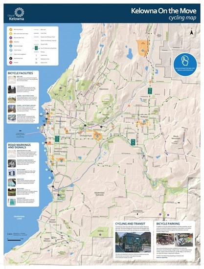
Kelowna cycle routes can be viewed here.
The City's Pedestrian and Cycle Master Plan can be seen here, although it's already a little bit dated since it was adopted in 2016.

Kelowna On the Move cycling map.
Image Credit: City of Kelowna
To contact a reporter for this story, email Rob Munro or call 250-808-0143 or email the editor. You can also submit photos, videos or news tips to the newsroom and be entered to win a monthly prize draw.
We welcome your comments and opinions on our stories but play nice. We won't censor or delete comments unless they contain off-topic statements or links, unnecessary vulgarity, false facts, spam or obviously fake profiles. If you have any concerns about what you see in comments, email the editor in the link above.
News from © iNFOnews, 2019