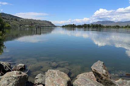
The Thompson River continues to drop in Kamloops after reaching a high of about 6.5 metres last week.
(JENNIFER STAHN / iNFOnews.ca)
June 03, 2014 - 2:58 PM
KAMLOOPS - River levels north of and within Kamloops are down while the South Thompson River at Chase continues to rise.
At Chase the river sits at a one in two year flow level of almost 1,000 cubic metres per second, which is up more than 100 cubic metres per second just a last week ago. It is one of the few rivers in the province not receding.
North of Kamloops the Clearwater River high streamflow advisory ended Friday. It reached a flow level high that happens about once in twenty years. It's down to a two year level of 990 cubic metres per second. A little farther south the North Thompson River, which was also under a high streamflow advisory last week, has dropped about 600 cubic metres per second to 1,600 cubic metres per second at McLure over the past week.
In Kamloops the Thompson River dropped more than half a metre in the past five days from about 6.5 m to less than 6 m. There is a bit more clearance under the CN rail bridge and the water filling the Rivers Trail underpass at the bridge is starting to recede though the trail remains closed.
Improved weather this week, combined with less rainfall than originally forecast over the past week is helping to keep the rivers lower than first expected. While little rainfall is expected this week there is a chance of thunderstorms today and showers tomorrow which combined with continued snow melt at higher elevations could cause rivers to rise a bit again.
To contact a reporter for this story, email Jennifer Stahn at jstahn@infotelnews.ca or call 250-819-3723. To contact an editor, email mjones@infotelnews.ca or call 250-718-2724.
News from © iNFOnews, 2014