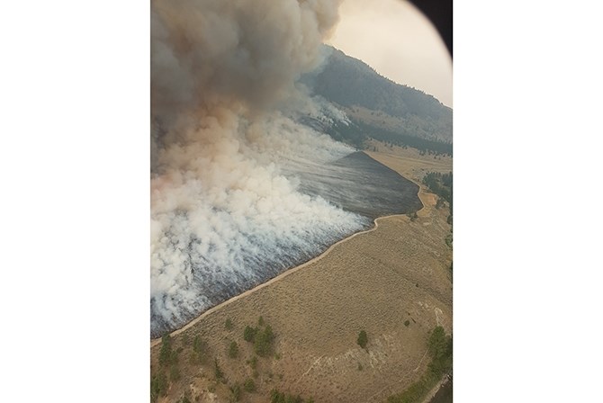
The East Flank burn-off operation on Aug. 2, 2018.
Image Credit: B.C. Wildfire
Republished August 05, 2018 - 8:46 AM
Original Publication Date August 05, 2018 - 7:27 AM
KEREMEOS - Though weather may be cooperating with crews working on the Snowy Mountain wildfire, our neighbours to the south are keeping an eye on it.
The fire saw cooler temperatures and some spotty precipitation yesterday, Aug. 4, with winds shifting from the north to south, and are now prevailing from the north again. The precipitation raised the minimum relative humidity and some calmer overnight winds worked in crews’ favour. There was no additional fire growth last night. Crews will continue to work on the southeast flank to protect adjacent properties, and are also positioned on the north flank to tie the fire perimeter into rocky slopes to keep it from wrapping around the mountain towards the Keremeos area.
The fire remains to the west of Chopaka Road, but is burning in a southward direction and the south flank and is approximately three km from the U.S. border. The B.C. Wildfire Service Incident Management Team assigned to the Snowy Mountain Fire is working collaboratively with the U.S. Forest Service, U.S. Bureau of Land Management, and the Washington State Department of Natural Resources given the fire's proximity to the border and expectation that the fire will continue to move south if prevailing strong winds come from the north.
B.C. Wildfire Service night crews responded in conjunction with the Keremeos Fire Department to prioritize life and safety within the evacuation order area. Additional resources were deployed to assist, including initial attack crews and officers out of Penticton and B.C. Wildfire Service Incident Management Team staff. Several outbuildings and pieces of equipment were lost, but no primary homes were affected.
The steep terrain is inoperable in some areas, and poses a safety risk to firefighting personnel. Crews are being strategically placed where it is safe and where suppression objectives can be met. A media release says 80 firefighters, three helicopters, and four heavy equipment are positioned in rotations for 24 hour coverage, working on the south flank to protect communities around where evacuation orders have been implemented. Control lines are being constructed with the heavy equipment.
Crews are supported by bucketing helicopters as they work south to conduct burn-offs as safe conditions allow to remove fuel from the slopes adjacent to properties in order to stop the fire from moving forward. Structural protection specialists will continue to assess properties on the valley bottom, moving south along the Chopaka Road.
The Lower Similkameen Indian Band has issued an evacuation order for 21 homes.
Three properties in this area are also on evacuation order, and the Regional District of Okanagan-Similkameen has declared a state of local emergency south of Cawston.
Smoke is drifting from the incident to adjacent areas, and the smoke column and open flame is visible from the surrounding communities. An Area Restriction Order was put in effect noon, July 28, 2018 and on Aug. 3, 2018 for Crown land in the vicinity of Placer Lake to protect public safety and the safety of firefighting personnel.
In the early morning period yesterday, two new fires were reported within the Lower Similkameen Indian Band jurisdiction. These new fires are not spot fires resulting from the winds experienced on the Snowy Mountain Fire Friday night. As initial attack is the priority, B.C. Wildfire Service crews were reassigned to the Snowy Mountain Fire to respond to the two new fires. Highway 3 is now open in both directions, but drivers are encouraged to check Drive B.C. for updates.
Friday night, aggressive fire behaviour occurred on the Snowy Mountain Fire with extreme winds out of the north. The fire remained to the west of Chopaka Road, but is burning in a southward direction. B.C. Wildfire Service night crews responded in conjunction with the Keremeos Fire Department to prioritize life and safety within the evacuation order area. Additional resources were deployed to assist, including initial attack crews and officers out of Penticton and B.C. Wildfire Service Incident Management Team staff. Several outbuildings and pieces of equipment were lost, but no primary homes were affected.
The Snowy Mountain wildfire has been burning after a suspected lightning strike on Tuesday, July 17, 2018.
—This story was updated on Sunday, Aug. 5, 2018 at 8:46 a.m. to include new information.
—This story was corrected for the spelling of "border" on Sunday, Aug. 5, 2018 at 11:54 a.m.
For more information:
Go here for the latest information on the Snowy Mountain Wildfire.
Go here for the latest information, evacuation orders and alerts, from the Regional District of Okanagan-Similkameen Emergency Operations Centre.
For the latest on road closures go to the Drive B.C. website here.
For the latest information on air quality go here.
To contact a reporter for this story, email Shelby Thevenot or call (250) 819-6089 or email the editor You can also submit photos, videos or news tips to the newsroom and be entered to win a monthly prize draw.
We welcome your comments and opinions on our stories but play nice. We won’t censor or delete comments unless they contain off-topic statements or links, unnecessary vulgarity, false facts, spam or obviously fake profiles. If you have any concerns about what you see in comments, email the editor in the link above.
News from © iNFOnews, 2018