
Quadra Island resident Bernie Amell, hand-watering his garden during a provincewide drought, is part of a team of local volunteers striving to develop water security for the community.
Image Credit: Rochelle Baker, Local Journalism Initiative
September 08, 2023 - 9:00 AM
As a landscape architect specializing in wetland restoration, Bernie Amell knows how water moves across the landscape.
However, he has had a crash course in drought after Amell and his wife moved to their Quadra Island agricultural acreage on B.C.'s so-called “Wet Coast” three years ago.
“We arrived in 2021, in the ‘heat dome’ summer, and the shallow well dried up,” said Amell, a member of Quadra Island’s Climate Action Network (I-CAN).
“We had to buy water in jugs while we were building the house. We could barely water any plants in the garden.”
Most of Quadra’s 2,700 residents depend on groundwater, from shallow or drilled deep wells, to meet their water needs,
It’s not uncommon for some shallow wells on the island to run dry during a hot summer, Amell said. With future summers only expected to be drier and hotter, the vulnerability of Quadra’s deep-water wells and groundwater resources remains an open question, Amell said
“It’s definitely an issue on the horizon,” he said.
As a result, I-CAN’s water security team has launched an ambitious project to gather data on the health of the island’s aquifers and get a sense of how much water is being extracted and if they are recovering or not.
That way, an analytical system can be set up to determine sustainable water-use thresholds, boost the community’s climate resilience and avoid a water crisis, said islander Nick Sargent, a retired hydrogeologist who is leading the aquifer study.
The idea is to avoid situations that have developed in the Okanagan Valley and on the southern Gulf Islands where competing demands on water have exceeded supply for well over a decade.
B.C. wracked by unprecedented drought
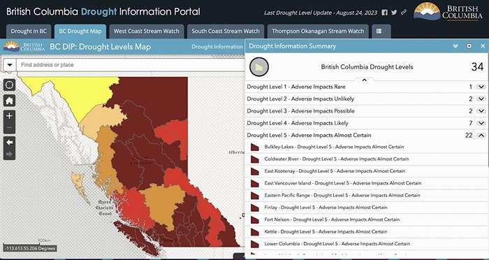
B.C.'s update on Aug. 24, 2023, shows 85 per cent of provincial water basins are in the grips of severe drought.
Image Credit: Province of BC
Quadra Island, east of Campbell River on Vancouver Island, along with most of the province, is weathering the twin crises of prolonged drought and record-breaking wildfires.
Eighty-five percent of B.C.’s 34 water basins are experiencing severe drought. And more than 55 per cent, including Quadra Island, are at Level 5 on the provincial drought scale — the point when adverse socioeconomic or ecosystem impacts are almost certain.
Drought conditions are fuelling the wildfires tearing across the province, which have scorched more than 1.73 million hectares of land, sparked a provincewide state of emergency and more than 150 evacuation orders and alerts and the exodus of as many as 30,000 people from their homes from badly hit areas like Kelowna and the Central Okanagan and Shuswap regions.
On Quadra Island, extreme drought is no longer an exceptional event. The island and the wider eastern Vancouver Island water basin have suffered Level 5 droughts for the past three summers in a row.
Drought shrivels rivers and streams and threatens wildlife and fish habitat, especially Pacific salmon stocks, which are already on the brink of extinction. As the surface water dries up, there’s additional pressure on groundwater resources and increased competition between various water users.
The entirety of Vancouver Island, where climate change has led to declining snow packs and meltwater, has been suffering a Level 5 drought since mid-July. The province has imposed temporary water restrictions in watersheds for the Tsolum River and Koksilah and Cowichan rivers in central Vancouver Island, prohibiting industry and farmers growing forage crops for animals from using surface or well water in order to preserve water for fish, livestock and growing food.
Scarcity of groundwater data
Unlike Vancouver Island, Quadra doesn’t have mountains with snowpacks or municipal water reservoirs to draw on, Sargent said.
It’s largely dependent on rainfall or surface water like creeks, streams and lakes to recharge underground aquifers.
But like most small rural populations in B.C., the level of Quadra’s groundwater resources and the effects of drought and other climate changes on aquifers and the community’s water security is largely a mystery.
Most of the province’s efforts to determine groundwater availability are limited to densely populated areas. The island has only one provincial observation well, said Sargent. It doesn’t provide enough data for a complete understanding of the island’s aquifers, their composition and water levels or recharge rates, especially when stressed by drought and user demand.
The province has flagged the well as suffering a large rate of decline, with water levels dropping 12 centimetres annually. Observation well levels in other Vancouver Island hot spots, including Qualicum, Parksville and Lantzville, are similarly trending downward at more than 10 centimetres annually.
“It doesn’t mean the sky is falling,” said Sargent of the well’s downward trend, noting severely stressed aquifers in places like Arizona in the U.S. have suffered water drops of hundreds of metres.
“But it is about 10 centimetres a year, which on the face of it is not much, but every 10 years, that's a metre — so it’s something to observe and be cautious about.”
The province has mapped the general footprint of the Quadra’s aquifers but the volunteer water security team is collaborating with the We Wai Kai First Nation and Quadra Island Salmon Enhancement Society for a more detailed survey of the island’s groundwater, Sargent said.
I-CAN partnered with Vancouver Island University, which studied geographic layers on the southern densely populated portion of the island to improve understanding of how water or pollutants might filter into aquifers. It has also staged a local campaign asking islanders to register their wells with the province to get a better understanding of water use.
Most importantly, the water security team has received a great response from local residents willing to let I-CAN monitor their household wells to get better data on water levels and demand. This information will feed a mathematical computer model to determine sustainable water use levels, Sargent said.
Monitoring domestic wells isn’t ideal, Sargent said. “But they're certainly far better than nothing, and they're far, far cheaper than trying to grow a network of monitoring wells.”
The water security project has been underway for a couple of years and will likely take another five to six years to finish.
“The high-level goal is to have a sustainability plan for the island, which takes into consideration both climate change and population growth,” Sargent said.
— This story was originally published by Canada's National Observer.
News from © iNFOnews, 2023