
The Cottonwood Beach rec site is one of several sites subject to an area restriction in place at least until Sept. 15, 2018.
Image Credit: Rec Sites and Trails B.C.
August 14, 2018 - 11:29 AM
NORTH OKANAGAN - People are being asked to give B.C. Wildfire crews room to safely battle an out of control wildfire near Mabel Lake.
The Regional District of North Okanagan requested today, Aug. 14, that residents keep a safe distance from KM 10 to 59 on the Mabel Lake forest service road to allow B.C. Wildfire Service crews space while they respond to fires in the Mabel Lake region.
The Mabel Creek wildfire, roughly six kilometres east of Mabel Lake, is as estimated 1,860 hectares and is burning out of control. Other smaller fires are also burning in the region.
The latest road closures add to an existing area restriction order put in place on Aug. 4. Now, there is a road closure in effect along Mabel Lake Road to all recreational traffic from KM 10 (North of Mabel Lake Provincial Park) to KM 59 (at the junction of Highway 1), including all recreational sites along that section of road, the regional district says in a media release.
“Our main goal is to ensure the safety of the community, as well as the safety of those protecting it,” general manager of community services Mike Fox says in the release. “Closing off sections of Mabel Lake Road will decrease the risk in vehicle collisions due to hazardous road conditions, and also increase the safety of our forestry crews.”
Residents living in the Mabel Lake Holdings community, or other private residences along Mabel Lake Road are not affected by the closure. The purpose of closing sections of this area is to assist with appropriate staging to face the fires with full road access and increased safety for forestry crews and industry partners, the district says.
“The safety of the public and responders is our highest priority, and these roads are narrow with limited visibility,” incident commander Jane Park says in the release. “These factors, combined with the fire hazards is what has caused these closures. We are working with Compliance and Enforcement Natural Resource Officers to patrol the closed areas with onsite security.”
For more information about active wildfires, go here.
For more on the Mabel Creek wildfire, and other fires burning near it, go here.
For a list of recreation site closures, go here.
Residents can also receive instant updates on all Emergency Management topics by subscribing to the RDNO email list here.
For further information, contact the regional district at 250-550-3700 or communityservices@rdno.ca.
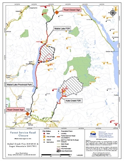
A map showing road closures around Mabel Lake due to wildfire activity in August 2018.
Image Credit: Regional District of North Okanagan
To contact a reporter for this story, email Charlotte Helston or call 250-309-5230 or email the editor. You can also submit photos, videos or news tips to the newsroom and be entered to win a monthly prize draw.
We welcome your comments and opinions on our stories but play nice. We won't censor or delete comments unless they contain off-topic statements or links, unnecessary vulgarity, false facts, spam or obviously fake profiles. If you have any concerns about what you see in comments, email the editor in the link above.
News from © iNFOnews, 2018