
Pentitcton firefighters fight a strong current at the Skaha Lake end of the Penticton river channel today, June 6, 2017. The channel has been enduring higher than design flows for several weeks as dam operators release as much water as possible from Okanagan Lake.
(STEVE ARSTAD / iNFOnews.ca)
June 06, 2017 - 6:30 PM
PENTICTON - As the damage, inconvenience and cost of this year’s high water levels in the Okanagan continues to grow, many are beginning to question who is responsible.
Calls for a review of flood control operations are growing as Regional District of Okanagan Similkameen directors began questioning who was responsible during a visit by MLA Dan Ashton last week.
Putting a human face to that question might be difficult, however, as the weather patterns and environmental conditions of the Okanagan over the past several months have resulted in unprecedented conditions, at least in terms of modern water management.
Ministry of Forests, Lands and Natural Resource Operations Public Safety and Protection Section Head Shaun Reimer says 1997 was the last year the lake was significantly lowered in anticipation of spring floods, and that didn’t stop the lake from reaching problematic levels.
“That year, an extreme snowpack started building before Christmas (1996) resulting in historically high inflows into the lake. The difference between 1997 and 2017 is this year, we had low to average snowpacks through April 1. The 2017 snow conditions did not indicate we were in for a high water year like they did in 1997,” Reimer says, noting snow basin indices for the Okanagan were as follows:
-
Feb. 1- 79 per cent
-
March 1- 86 per cent
-
April 1-105 per cent
-
May 1- 147 per cent
Reimer says forecasting models were based on low snowpack levels, never suggesting the historic volume inflows now being experienced would materialize.
“By way of comparison, snow basin indices in 2016 were 122 per cent for February, 123 per cent for March, and 131 per cent for April, and we had no flooding last year,” he says.
Reimer says lowering the lake each year just in case of flooding could result in a lack of water, resulting in potentially disastrous effects on the fishery, as well as significant issues agriculturally, environmentally and economically.
Reimer says the present flow in the Penticton channel of the Okanagan River is higher than it was at any time during the 1990s. He says one centimetre of lake water is worth one day of discharging 40 cubic metres per second through Okanagan Lake dam at the channel mouth near the SS Sicamous in Penticton.
“At present, we are discharging 73 cubic metres per second, which would be worth 1.8 centimetres of water per day, while the channel below the dam is designed for 60 cubic metres per second of flow,” Reimer says.
Between April 30 and June 3, weekly inflows into Okanagan Lake have been greater than 100 million cubic metres, translating into a 169 cm depth of water entering Okanagan Lake in that five week period.
“Staff can only lower the lake by approximately 11 to 12 cm per week due to the limits of the infrastructure and to avoid severe flooding downstream. While 169 cm has entered Okanagan Lake since May 1, we’ve only been able to release 55 cm,” he says, adding the amount of inflow into Okanagan Lake is the highest on record.
Water flow through Okanagan Lake dam on May 7, 2017.
(STEVE ARSTAD / iNFOnews.ca)
Reimer says ministry guidelines also restrict drawdown of the lake to protect kokanee and sockeye. The guidelines can be overridden if flooding is expected, but there were no indicators for staff to anticipate a flooding event last fall.
The river constraint guideline was overridden this year because of the constant rainfall and channel flows ramped up to above design flows in the third week of April.
Reimer says in past years the Similkameen has risen and caused back flows to occur into Osoyoos Lake, causing it to rise rapidly.
“That hasn’t been an issue this year,” he says.
Reimer believes the single biggest factor contributing to this year’s high water was the unforeseen precipitation that began in March and didn’t let up until May.
“It contributed directly to lake inflow, but also built up a late snowpack,” he says.
Reimer notes the Okanagan lake and river system is not particularly unique from other river systems in the province when it comes to problems arising from flood years such as this one.
“Clearly, other areas and river and lake systems in B.C. are facing flood conditions and some regions are likely just starting,” he says.

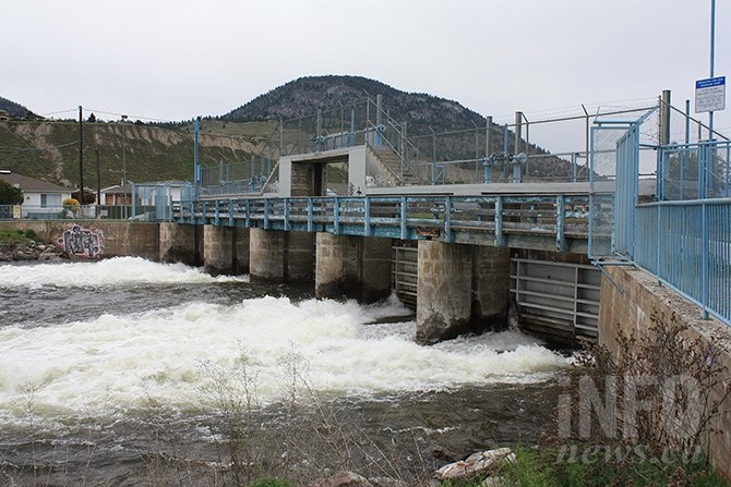
Water flow through the dam on June 5, 2017.
(STEVE ARSTAD / iNFOnews.ca)
To contact a reporter for this story, email Steve Arstad or call 250-488-3065 or email the editor. You can also submit photos, videos or news tips to the newsroom and be entered to win a monthly prize draw.
We welcome your comments and opinions on our stories but play nice. We won't censor or delete comments unless they contain off-topic statements or links, unnecessary vulgarity, false facts, spam or obviously fake profiles. If you have any concerns about what you see in comments, email the editor in the link above.
News from © iNFOnews, 2017