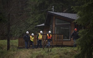
Workers from the Nanaimo Regional District inspect a home at Little Qualicum River Estates near Qualicum, B.C., Thursday, Dec. 11, 2014. A mudslide in the area has forced an evacuation order as heavy rains continue. THE CANADIAN PRESS/Jonathan Hayward
Republished December 11, 2014 - 3:49 PM
Original Publication Date December 11, 2014 - 8:45 AM
QUALICUM BEACH, B.C. - Torrential rain and strong winds carried by a series of weather systems have hammered British Columbia's south coast and more is to come.
The heavy rains have saturated the ground and swelled rivers, prompting a mudslide that rolled over a Vancouver Island home. Flood warnings or high-river advisories have also been issued for residents living along numerous waterways.
Fifteen homes in a neighbourhood above the Little Qualicum River have been evacuated and another 70 are on evacuation alert after a wall of mud partially buried a two-storey home with a man inside on Wednesday.
Fire crews used a chainsaw to free the man who was trapped inside the basement of his home, said Fire Chief Nick Acciavatti in the community of Dashwood.
An emergency reception centre has been set up nearby for those residents who aren't allowed back to their homes.
Geoff Garbutt, a general manager for the Regional District of Nanaimo, said a geotechnical engineer was heading to the site to assess the slope Thursday.
The neighbourhood above the river was built on a former timber cut block, Garbutt said.
"We've had a lot of rain and there are some steep slopes there," he said, adding officials are focused on keeping track of what's happening in the area.
Garbutt said the Little Qualicum River is like many other rivers in the area — swollen to near overflowing.
The B.C. River Forecast Centre has issued flood watches for the four major rivers on Vancouver's North Shore, the Squamish River and on Howe Sound.
High streamflow advisories are up for numerous rivers in the Lower Mainland, the Fraser Valley and along the Sea-To-Sky corridor from Horseshoe Bay to Whistler.
An evacuation order and alert for residents in the Vancouver Island City of Courtenay was lifted Thursday after officials warned residents earlier in the week that three rivers in the area might flow over their banks.
Also on Thursday in the same area, the Comox Valley Regional District issued a boil water advisory for thousands of residents.
"Due to the intense rainfall experienced over the last several days, turbidity levels have risen in both Comox Lake and the Puntledge River," the advisory said.
Users, especially those with compromised immune systems, were advised to boil their drinking water for at least one minute.
Environment Canada meteorologist Jennifer Hay said the three days of wet weather have been a "fairly extreme event."
And there's more rain and wind to come.
"We're thinking that this (system) is less wet," she said of the pending storm.
But Hay said the cumulative affect of more precipitation is being felt.
"It's the sustained impact of the ongoing weather and wind and some melting snow, combined with high rivers and high tides. We are starting to see some impacts."
Port Alberni, on central Vancouver Island, was pounded during the first two storms, getting hit with 190.8 millimetres of rain over a two-day period starting Monday.
North Courtenay, Howe Sound and Powell River all received more than 100 millimetres of rain during the same period.
(CKAY)
News from © The Canadian Press, 2014