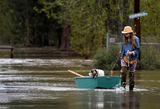
Katie Condon ferries her 13-year-old basset hound, Fran, for a respite from the floodwater surrounding her home at the north end of Tower Street on the outskirts of Missoula, Mont., Monday, May 7, 2018. (Kurt Wilson/The Missoulian via AP)
Republished May 07, 2018 - 3:02 PM
Original Publication Date May 07, 2018 - 10:56 AM
HELENA, Mont. - Sheriff's deputies in Montana went door to door Monday in a neighbourhood along the rising Clark Fork River warning residents to prepare to leave, with the river expected to reach major flood levels in Missoula for the first time in 37 years.
The Clark Fork, which courses through downtown Missoula and past the University of Montana campus, could eventually threaten between 800 and 1,300 homes before it crests on Friday, National Weather Service meteorologist Alex Lukinbeal said.
That 800- to 1,300-home estimate includes low-lying areas from eastern Missoula near U.S. Highway 10 to where the Clark Fork meets the Bitterroot River west of the city. Downtown Missoula is in that stretch, though officials are uncertain what effects, if any, the flooding will have in that levy-protected area.
"We haven't seen river rises like that in a very long time," Lukinbeal said. "It's really difficult to say what might happen with any flooding issues in the downtown area itself."
Water already surrounded at least 10 homes Monday morning in the Orchard Homes neighbourhood of Montana's second-largest city, where Missoula County deputies were handing out evacuation warnings. The same area had seen some flooding last week, but it was expected to be much more widespread this time.
By early Tuesday, floodwaters were expected to threaten dozens more homes, and officials were telling residents not to wait for an evacuation order if they can leave now.
"We always encourage people to self-evacuate if they can," Missoula County sheriff's spokeswoman Brenda Bassett said.
Rivers and streams across western and parts of central Montana are swollen and overflowing due to the rush of melting snow from a very snowy winter. The western Montana snowpack was 150 to 175 per cent of normal this year, which is one of the top five years for snowpack over the past three decades, Lukinbeal said.
All that melting water is expected to cause the Clark Fork to rise above 13 feet (3.9 metres) for only the sixth time since records have been kept, and for the first time since 1981, Lukinbeal said.
Flood warnings and advisories also have been issued for western Montana waterways with less residential development, including the Bitterroot and the Blackfoot rivers.
Across the Continental Divide in Helena, some 110 miles (177 kilometres) away from Missoula, roads and homes were expected to be flooded as several streams rose out of their banks.
Officials at an elementary school cancelled classes and residents of a trailer park waded through knee-high water. Volunteers lined roadways and residential areas with sandbags to protect homes.
Lukinbeal said most of the rivers are expected to crest Thursday and Friday. A storm is predicted to move through the area that could slow the runoff by re-freezing the snowpack in higher elevations, but the high water is expected to remain for a while, he said.
"It's looking like the water's going to be well above moderate flood stage through at least the next week," he said.
News from © The Associated Press, 2018