
Ministry of Transportation and Infrastructure contractors bring out the heavy machinery to clear snow off highways hit by a controlled avalanches. Depending on the amount of debris, it takes between two and four hours to clear it all and reopen the highway.
Image Credit: TranBC
January 11, 2014 - 11:21 AM
KELOWNA – The weather in the valley bottoms this weekend is all about melting, rain and even some sunshine. At higher elevations another big dump of snow is underway.
You may want to delay any road trips to the lower mainland or Alberta because an intense Pacific frontal system moving across the B.C. Interior Saturday.
Environment Canada has issued a Special Weather Statement for the region.
The frontal system is producing heavy snow over many of the Southern Interior passes.
About 20 cm of snow is expected at the Coquihalla summit on Highway 5. The Allison Pass and the Kootenay Pass on Highway 3 will also get up to 20 cm. Roughly 10 cm is expected for the Eagle Pass and the Rogers Pass on the TransCanada.
As the Pacific frontal system moves into Alberta, it will be followed by a strong unstable westerly flow which will bring more snow to the same mountain passes overnight Saturday. Most will get another 10 cm of snow, although the Coquihalla summit can expect another 20 cm.
The heavy snowfall should end by Sunday morning.
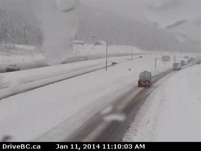
The view from the Drive B.C. camera on Highway 5 near the Coquihalla summit looking south on Saturday, Jan. 11, 2014.
Image Credit: Drive B.C.
Drive B.C. has issued a travel advisory on the Coquihalla due to heavy snow and rain. It’s advising drivers to exercise caution and consider alternate travel plans.
Avalanche control is closing the TransCanada left and right Saturday. From 1:30 to 3:00 p.m. Highway 1 will be closed west of Revelstoke and east of Golden.
There could be closures of up to 4 hours in length in Glacier National Park.
Meanwhile those heading into the backcountry this weekend to ski, snowshoe or sled need to be aware of the high avalanche risk.
The Canadian Avalanche Centre is warning people to avoid all avalanche terrain.
The avalanche risk is considered high in the North and South Columbia regions which include the Caribou, Monashee and Selkirk mountains. The risk is also high in the Kootenay Boundary region and Glacier National Park.
All the new snow expected, along with a wind, has avalanche forecasters forecasting increasing danger through the weekend.
Recreational users are advised to stay away from steep slopes. In most cases the avalanche danger is listed as considerable or moderate at or below the tree line.
Be sure to visit the Canadian Avalanche Centre’s website and check the bulletins for the region you’re planning to head to.
To contact the reporter for this story, email halexander@infotelnews.ca or call 250-491-0331.
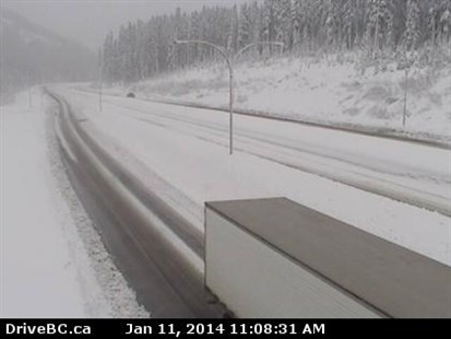
The view from the Drive B.C. camera on Highway 5 near the Coquihalla summit looking north on Saturday, Jan. 11, 2014.
Image Credit: Drive B.C.
News from © iNFOnews, 2014