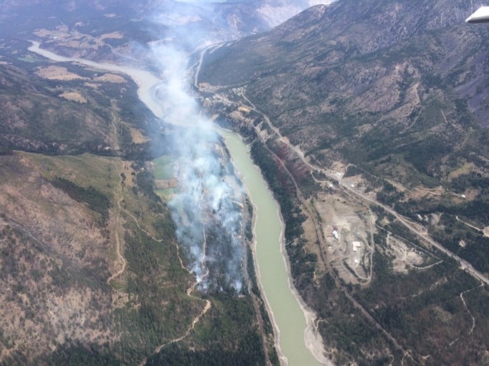
An aerial photo of the South Spencer Road fire 2 km south of Lytton Aug. 31.
Image Credit: B.C. Wildfire Service
Republished August 31, 2016 - 4:48 PM
Original Publication Date August 31, 2016 - 1:11 PM
UPDATE: 7:30 p.m., Wednesday, Aug. 31
The size of the South Spencer Road fire has tripled in the last three hours, and officials believe it is human caused. It is now estimated to be 300 hectares in size and it is no longer contained.
Investigators are still working to confirm the cause.
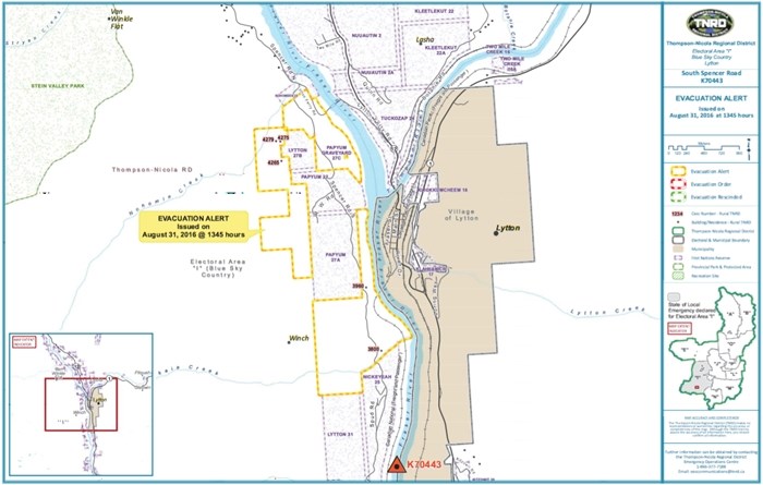
The area of the evacuation alert has been expanded to include the entire area between the CN train bridge in Lytton north to the Stein River.
There is an evacuation order and alert in place for several homes in the area.
B.C. Wildfire Service advises the public to contact Lytton First Nation or the Thompson Nicola Regional District for more information on the evacuations.
There are currently no air quality advisories in place. B.C. Wildfire Service says 16 firefighters will remain on scene overnight to battle the blaze.
4:38 p.m., Wednesday, Aug. 31
The South Spencer Road fire has now grown to an estimated 100 hectares.
B.C. Wildfire Service indicates on their website the blaze is now 25 per cent contained, with 53 firefighters, three helicopters and five air tankers fighting it.
It's now been classified as a rank three to four fire, which means it's moving at a moderate rate. The aggressive fire behaviour, according to B.C. Wildfire Service. is partially due to the strong winds in the valley. The fire is currently moving upslope away from homes.
3:46 p.m., Wednesday, Aug. 31
KAMLOOPS - An evacuation order has been issued for 10 homes as a 17-hectare fire burns 2 kilometres south of Lytton this afternoon.
Fire information officer Kelsey Winter says the South Spencer Road fire, which was reported earlier this afternoon, Aug. 31, is displaying rank three behaviour, meaning there is some candling of trees. High winds in the valley are also an issue.
“Smoke will be visible in the surrounding area,” she says. “At this time the (Trans Canada) is open.”
There are 44 firefighting personnel on the ground with three helicopters and five air tankers assisting.
Rosalin Miles with the Lytton First Nation says the area under evacuation order issued today, Aug. 31, is the same area as the Cisco Road fire last summer.
Having another evacuation order on the same homes is hard on the residents right now, she says.
"We're waiting to find if they can get (the fire) under control," she says. "We maybe have to increase that order, but hope not to."
The Thompson-Nicola Regional District has issued an evacuation alert for the west side of the Fraser River from the intersection of Lytton Ferry Road and South Spencer Road, south to the northern boundaries of Lytton IR 25 and Lytton IR 31, including 4279, 4275, 4265, 3960 and 3800 South Spencer Rd.
While the fire is believed to be human caused, the exact cause is still under investigation.

Map of area under an evacuation alert as of 3 p.m., Wednesday, Aug. 31, 2016.
Image Credit: Contributed
— This story was updated at 2:13 p.m., Wednesday, Aug. 31, 2016 with new information about the size of the fire and the force fighting it.
— This story was updated at 3:17 p.m., Wednesday, Aug. 31, 2016 to correct the number of homes under evacuation order and to add a map of the area under evacuation alert.
To contact a reporter for this story, email Brendan Kergin or call 250-819-6089 or email the editor. You can also submit photos, videos or news tips to the newsroom and be entered to win a monthly prize draw.
We welcome your comments and opinions on our stories but play nice. We won't censor or delete comments unless they contain off-topic statements or links, unnecessary vulgarity, false facts, spam or obviously fake profiles. If you have any concerns about what you see in comments, email the editor in the link above.
News from © iNFOnews, 2016