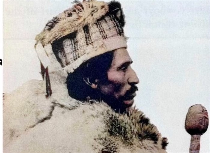
There is no known photo of Grand Chief Nicola but he may have looked something like this. The location of his settlement and the St. Joseph's Mission he allowed to be built next to it is being hotly debated by local historians.
Image Credit: SUBMITTED/ David Gregory
March 09, 2024 - 7:00 AM
The location of the first, albeit brief, European settlement in the Okanagan is now the subject of a heated debate between amateur historians in Kamloops and Summerland.
Last month, iNFOnews.ca interviewed Summerland historian David Gregory about his long-standing belief that a Jesuit priest named Nobili founded the St. Joseph’s Mission in what is now Summerland in 1845, well ahead of the 1859 Father Pandosy Mission in Kelowna which is often referred to as the first European settlement in the region. But it's being hotly contested as is our story on it.
READ MORE: Why Kelowna gets credit for first European settlement in Okanagan
“This article describes a theory by the amateur historian, David Gregory, who believes that the earliest Jesuit building in the Okanagan valley, the 1846 Mission of Father Giovanni Nobili, was located, not at the north end of Okanagan Lake (where all other scholars have placed it), but instead at Summerland (where Mr. Gregory lives),” Thompson Rivers University professor Craig Jones wrote in an email to iNFOnews.ca.
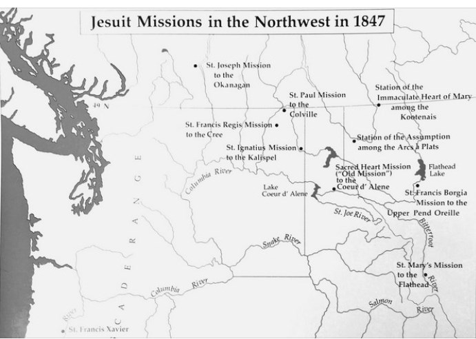
Part of Gregory’s argument is based on a map he says was published by the Society of Jesus in 1847 called ‘Jesuit Missions in the Northwest in 1847.” It names St. Joseph’s Mission to the Okanagan and shows a dot in the Summerland area.
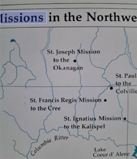
Jones claims the map was actually created in 1993 for a book called Sacred Encounters. The full title appears online as ‘Sacred Encounters: Father De Smet and the Indians of the Rocky Mountain West’ by Jacqueline Peterson and published by Washington State University.
The original map, Jones writes, has the dot for St. Joseph’s Mission in a different location, about 200 km east around the Kettle River or, perhaps, as far as the Arrow Lakes.
That, too, does not conform with other historical references to the mission being at the “head of the lake.”

This is the map that David Gregory says was made by the Society of Jesus in 1847 showing St. Joseph's Mission at Summerland.
Image Credit: Submitted/David Gregory

This is a section of the map that Craig Jones says was created in 1993 in the book Sacred Encounters, showing St. Joseph's Mission closer to the Arrow Lakes.
Image Credit: Submitted/Craig Jones
Gregory said the “head of the lake” reference was a misunderstanding of Nobili’s writings about Nicola’s Prairie, which he says is in Summerland and is where St. Joseph’s Mission was built.
In another email to iNFOnews.ca, Jones includes a detailed rebuttal to Gregory’s argument, citing historical sources that say Nobili built “St. Joseph’s Residence” in the lands that contained Grand Chief Nicola’s lodge and gardens at the head of Okanagan Lake, a little above present-day Vernon, called Nkama’pElEks (Head-of-Lake).
Gregory countered by saying some of Jones’ sources are “problematic” and points out, as well as a number of other things, that Nobili, in his letters, says the Mission was three days from the Columbia River.
It would be tough to reach Summerland by foot in three days, Gregory argued, let alone travelling all the way to the head of the lake.
There are also questions about the accuracy of longitude and latitude readings that Nobili attributed to the site.
“Gregory’s map is a forgery,” Jones writes in one email. “Mr. Gregory does not deny altering the map.”
“This clearly is a typo,” was Gregory’s response when told by iNFOnews.ca about Jones’ allegation of forgery. “The St Joseph Mission of the Okanagan site was accidentally placed by the Arrow Lakes. The Okanagan Mission location clearly belonged in the Okanagan. This was a typo and nothing more.”
And, just to be clear, while Jones portrays Gregory as an “amateur historian,” Jones is no professional himself.
Jones is a professor of law at TRU and, his email signature says, he is also “General Counsel” to the Premier. While he served as a counsel to Thomas Berger on The Nunavut Project, his CV on the university’s website does not include any references to any accomplishments as a historian.
Jones is, however, doing extensive research on Chief Nicola with a particular focus on a little known battle in the Vernon area and he has told iNFOnews.ca that he may be writing a book on that subject.
“Both Craig and I agreed there were errors," Gregory wrote in an email to iNFOnews.ca. “Not sure where he is going with this whole thing. Unusual debate between the two of us. I don’t appreciate his hostility.”
To contact a reporter for this story, email Rob Munro or call 250-808-0143 or email the editor. You can also submit photos, videos or news tips to the newsroom and be entered to win a monthly prize draw.
We welcome your comments and opinions on our stories but play nice. We won't censor or delete comments unless they contain off-topic statements or links, unnecessary vulgarity, false facts, spam or obviously fake profiles. If you have any concerns about what you see in comments, email the editor in the link above. SUBSCRIBE to our awesome newsletter here.
News from © iNFOnews, 2024