
Mission Creek in Kelowna is pictured.
Image Credit: Wikimedia Commons/Accuruss
February 08, 2015 - 8:32 AM
THOMPSON-OKANAGAN – It doesn’t happen often, but a perfect alignment of the right conditions may cause some flooding in the Southern Interior.
The warm Pacific air bombarding the region, thanks to the Pineapple Express, is creating above normal temperatures, which in turn are starting to melt the lower elevation snowpack. Add the still frozen ground in the valley bottoms to the mix and you get the perfect conditions for localized flooding, David Campbell with the B.C. River Forecast Centre says.
“It’s unusual to get that kind of event but when we get these really warm weather systems it is a possibility,” Campbell says. “It tends to be the creeks at lower elevations... typically it’s not the same as the large, full scale flooding we get in the spring, but it certainly can cause problems.”
He says the River Forecast Centre doesn’t typically issue public advisories for localized flooding issues.
“But certainly I wouldn’t be surprised if you start to see that kind of thing."
As for the state of the snowpack in the Southern Interior, it’s looking pretty good, about 90 per cent of normal for this time of year, according to the latest
Snow Survey and Water Supply bulletin from the River Forecast Centre.
“It’s a little low but (the readings are) kind of a double-edged sword,” Campbell says. “If the snowpack gets too high then we’re concerned about flood risk and if it’s too low we start getting worried about water supply.”
He admits water is a hot commodity in the Thompson-Okanagan.
More snow is likely going to fall adding to the snowpack before the winter precipitation period in the mountains is over, likely around the first couple weeks of April.
Environment Canada’s long range forecast models predict a warmer than normal pattern until spring.
“Up until now, the snowpack hasn’t been too heavily impacted by the warming temperatures in the Southern Interior but there is a couple months to go things could change a little bit,” Campbell says.
Then there’s El Nino.
“We’re in the midst of a pattern right now with warm water in the Pacific Ocean off the B.C. coast and while it’s not technically called an El Nino it does show the El Nino-type of pattern.”
That combined with the warming of the water at the equator combines to produce above normal temperatures in the Interior, he says.
"The long range models for precipitation tend to be less accurate than the temperature forecasts so right now it jumps all over the place,” Campbell says. “The forecast calls for a slight increase in precipitation over the next few months but I tend to take the forecast with a grain of salt.
He says they’ll have a better idea when the next Snow Survey and Water Supply bulletin comes out in the first week of March.
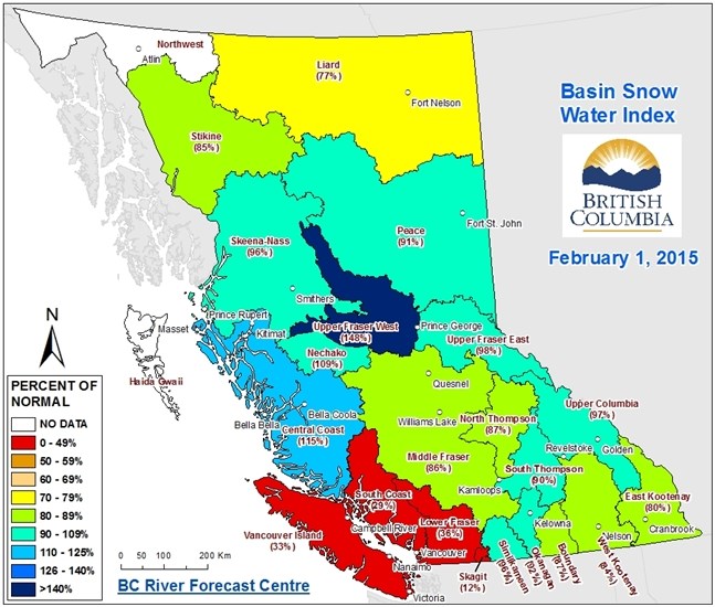
A map from the B.C. River Forecast Centre Snow Survey and Water Supply bulletin issued on Friday, Feb. 06, 2015 shows snowpack levels in the province.
Image Credit: Contributed
To contact the reporter for this story, email Howard Alexander at halexander@infonews.ca or call 250-491-0331. To contact the editor, email mjones@infonews.ca or call 250-718-2724.
News from © iNFOnews, 2015