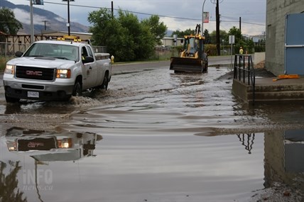
Heavy equipment was used to help clear out flooded areas in Kamloops Wednesday.
(JENNIFER STAHN / iNFOnews.ca)
July 24, 2014 - 11:26 AM
THOMPSON-OKANAGAN - Several rainfall records were broken Wednesday but a local meteorologist says it is the rate of the rainfall that is the big story.
“A record rain doesn’t really tell the story, the real story is the speed which it came out of the clouds,” Doug Lundquist of Environment Canada says. “You can have a non-record day but the speed will still be an impact.”
Lundquist had some reports of 20 millimetres falling in just 20 minutes, and some areas — such as the Shuswap and Lillooet areas — received as much as 40 cm in the past 24 hours, but he says it is hard to measure the exact rate because often the epicentre of the system does not travel right over the weather stations.
“It was a very, very high rain rate,” he notes. “I can’t see anywhere (in the Interior) that didn’t report any rain.”
Even after the storm ended rain continued to fall throughout much of the region and Lundquist says the rain will continue today before things dry out heading into the weekend.
While Lundquist believes the rain is good news for the fire situation B.C. Wildfire Fire Information Officer David Steeves says the rain probably did not help as much as people might think.
“The wet weather will give (crews) a bit of a reprieve and allow crews to do mop-up in areas they couldn’t get to before. The wet weather is a good thing all around, it will give a working window to push forward and make some good gains,” Steeves says. “(But) the type of precipitation we did have was extremely fast and came down hard. It couldn’t sink in… runs off instead. It is going to help, but only in the short term.”
Steeves is also concerned over the number of lightning strikes that occurred with the storm system and while they haven’t received any calls yet they do expect those calls to start coming in soon.
“We haven’t had any yet,” he says, adding, “The public is asked to call if they see any smoke they see. The possibility of additional fires is still very real. Call *5555 on your cell.”
Lundquist notes the lightning from the system is easily in his top three or five events for cloud to ground lightning strikes.
“I don’t remember seeing many more in the Southwest Interior,” he says. “There was probably more than I have ever seen.”
The campfire ban will remain in place throughout the Kamloops Fire Centre as well, except in Clearwater where it was lifted Wednesday afternoon.
“Things are going to get hot and dry by mid-afternoon tomorrow,” Steeves says, “And we will likely be back into high alert status.”
Quick facts about the July 23 storm system:
- One of the cells hit Kamloops squarely on, causing a lot of local flooding.
- We are in the hottest time of the year, which is also the most likely to produce severe weather.
- Severe storms like this one do occur somewhere in southern B.C. at least every year or two.
- The Kamloops Airport recorded 23.2 mm of rain Wednesday. The previous record was 22.9 mm in 1990.
- In Vernon 16.4 mm was recorded yesterday, causing some flooding.
- While Kelowna saw 29 mm in 24 hours, as of 5 a.m. Nearly 10 mm of that fell after midnight. In total 19.7 mm of rain fell just on Wednesday, slightly above the 18.2 mm record set in 1992.
- Penticton received 14.4 mm yesterday, well below the 28.6 mm record set in 1992.
- The Shuswap area was hit hard yesterday, with Salmon Arm seeing about 38 mm of rain, also enough for a new record.
- Thousands of people throughout the region lost power following the storm.
To contact a reporter for this story, email Jennifer Stahn at jstahn@infonews.ca or call 250-819-3723. To contact an editor, email mjones@infonews.ca or call 250-718-2724.
News from © iNFOnews, 2014