
The McIntosh Lookout in Kamloops.
Image Credit: Submitted/Enderby and District Museum
March 05, 2023 - 7:00 AM
A pioneer Okanagan photographer has gained attention recently with the discovery of his early chronicles of the Shuswap region.
While he’s said to have fallen in love with the Shuswap, Erskine Burnett lived in Coldstream, had an orchard in Oliver and documents life from Kamloops to Osoyoos from 1937 to 1950 both in photos and with stories.
“The Okanagan of those days sometimes lived up to its reputation of being wild and woolly,” he wrote in a section of his "B.C.’s Inland Empire" photo album that seems to date from 1947 near Vernon. “At a certain ranch, after the threshing was finished, the boss and the rest of the gang started to celebrate in no uncertain fashion. Big crop of wheat. Good prices. So why worry about the future?
“Next morning, the gang was still on hand and nothing in the house for breakfast so the boss took down his gun and went over to the corral with the intention of butchering a steer. The first shot failed to hit anything in the vital spot so the gun was handed over to someone else to try his luck but with no better results. And the same with a third embryo rifleman. Then a council of war was held and it was decided to return to the house and sleep it off rather than risk mutilating the whole herd.”
Burnett lived from 1878 to 1951, emigrating to Canada from Scotland 1897, according to a posting on the B.C. Regional Digitized History website where ‘B.C.’s Inland Empire’ can be viewed.
He moved to Coldstream in 1910, becoming a successful fruit farmer on Aberdeen Road. He also had a peach orchard near Oliver.
He created two sets of photo albums, complete with text that was typewritten and pasted in.
One album focused on the Shuswap and was compiled into "The Shuswap Country" by Salmon Arm historian Jim Cooperman last year.
READ MORE: 'Remarkable find': Rare historical Shuswap scrapbooks and photos in new book
That’s available for sale in regional museums, including the Enderby and District Museum where his "B.C.’s Inland Empire" collection resides.
It’s a collection of almost 500 photos, mostly his own but some from museum archives and others, mounted on white paper in a three-ring binder. The typewritten text explains each photo, some very briefly but others with anecdotes like the one above.
“I do have an additional (physical) copy of this book in Okanagan Special Collections,” UBCO archivist Paige Hohmann said in an email to iNFOnews.ca. “The book itself is fairly complex with many folded, pasted-in inserts. It’s quite a thing.”
Some of the writing, when viewed online, is faded beyond recognition and some type overlaps the photos. Still, it’s a treasure trove of early settler history in Kamloops and Okanagan.
READ MORE: The Kelowna police chief who murdered two people in broad daylight
This is how the McIntosh picture and story are displayed in the photo album.
Image Credit: Submitted/Enderby and District Museum
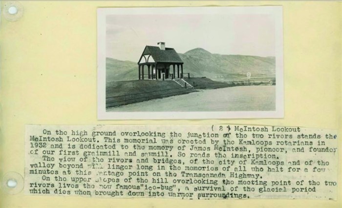
"B.C.’s Inland Empire" starts in Kamloops with things like the McIntosh Lookout pictured above.
“On the high ground overlooking the junction of the two rivers stands the McIntosh Lookout,” Burnett wrote. “This memorial was erected by the Kamloops Rotarians in 1932 and is dedicated to the memory of James McIntosh, pioneer and founder of our first grainmill and sawmill.
“The view of the rivers and bridges, of the city of Kamloops and of the valley beyond will linger long in the memories of all who halt for a few minutes at this vantage point on the TransCanada Highway. On the upper slopes of the hill overlooking the meeting point of the two rivers lives the now famous ‘ice-bug,’ a survival of the glacial period which dies when brought down into warmer surroundings.”
Another photo is of the Lady Dufferin.
“Wm. Fortuno, not related to A.L. Fortuno, was also one of the Overlanders and acquired the property where the Tranquille Sanitarium now stands,” Burnett wrote. “He built and operated the Lady Dufferin, which ran up the South Thompson in the 70s and 80s of the last century. Lord and Lady Dufferin travelled on this boat when visiting this part of the country during his term of office as Governor General.”
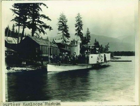
The Lady Dufferin.
Image Credit: Submitted/Enderby and District Museum
There are a number of photos of the 1947 Kamloops Fall Fair, which had been revived after a lapse of eight years.
“The four-horse team of the old B.C. Express Co. was also in the line of march,” Burnett wrote of the Fall Fair parade. “The box at the back held the Cariboo gold and the man on the top with the gun kept a weather eye open for the Dick Turpins of that day.”
Turpin was a British highwayman who lived from 1705-39 and was made famous in William Harrison Ainsworth’s ‘Rookwood’ that was published in 1834.
READ MORE: This 'gentleman' train robber was just passing through Kamloops when he got busted
Heading out of Kamloops to the east, was the Rotary Arch.
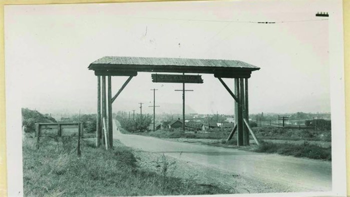
The Rotary Arch on the east side of Kamloops.
Image Credit: Submitted/Enderby and District Museum
“The traveller going east from Kamloops passes under the Rotary Arch inscribed – ‘Hla how ya, Tillicum.’ That is – ‘How are you, friend?’” Burnett wrote.
The journey continued on to Falkland.
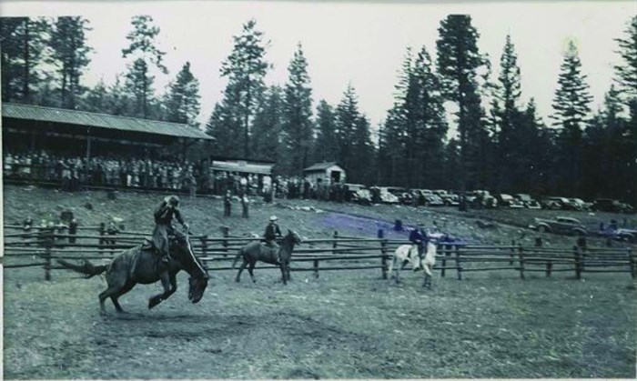
Falkland Stampede circa 1947.
Image Credit: Submitted/Enderby and District Museum
“Empire Day is Falkland’s big day,” Burnett wrote. “Then all roads lead to Falkland. The sports and stampede are held in the fine new park which is ideally situated just west of the townsite. There is a delightful informality about this annual event. We are once more on the frontier. It is the first stampede of the year in the interior.”
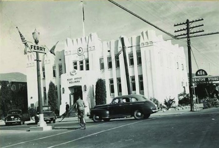
Kelowna's post office and federal building.
Image Credit: Submitted/Enderby and District Museum
The travelogue continues through Enderby, Armstrong and Vernon, with side trips to the Shuswap and places like Sugar Lake before moving further down the valley.
“Kelowna is known as the Orchard City and is the largest original shipping point for apples in Canada,” was one entry for that city. “For a number of years it was the battleground of the Co-operative versus the Free-for-all methods of handling the apple crop. This culminated in an incident in the early thirties during the ‘cent-a-pound or on-the-ground' movement when a number of growers lay down in front of a locomotive moving cars of fruit to an allegedly unrestricted market.”
READ MORE: Why there’s a tomb and not a university on Knox Mountain in Kelowna
Then there was the crossing of Okanagan Lake.
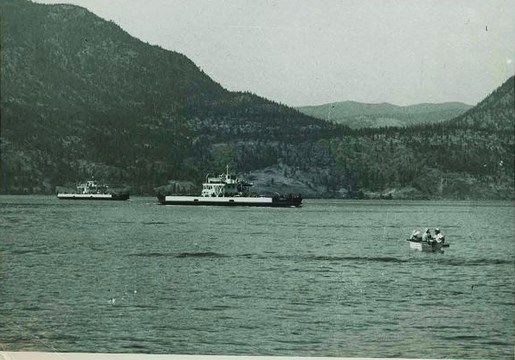
The early car ferry across Okanagan Lake at Kelowna.
Image Credit: Submitted/Enderby and District Museum
“Long before the Pendozi and the Lequime (car ferries) were put into operation car owners, wishing to cross the lake, went down to the shore where a two-car scow lay waiting,” Burnett wrote. “This scow was propelled across the lake by a boat lashed alongside but we have forgotten the nature of the motive power. Anyway, two planks were thrown across from the beach, you took a deep breath and, with luck, landed on the scow. On the far side, the landing process, including the deep breath, was the boarding process in reverse.
“Thereafter it was a case of a long long trail a-winding into the land of your dreams. There was no Westbank then. As we passed through what is now Peachland a girl, driving home the cows, looked longingly at the vacant seat beside the driver.”
Many of his photos are scenic shots, including the Ramparts near Summerland.
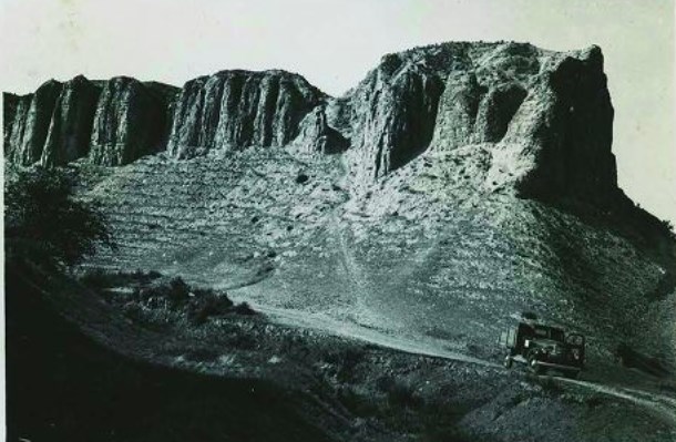
The Ramparts near Summerland.
Image Credit: Submitted/Enderby and District Museum
“Thousands of years of erosion by the very meagre precipitation of this country have produced this effect,” Burnett wrote.
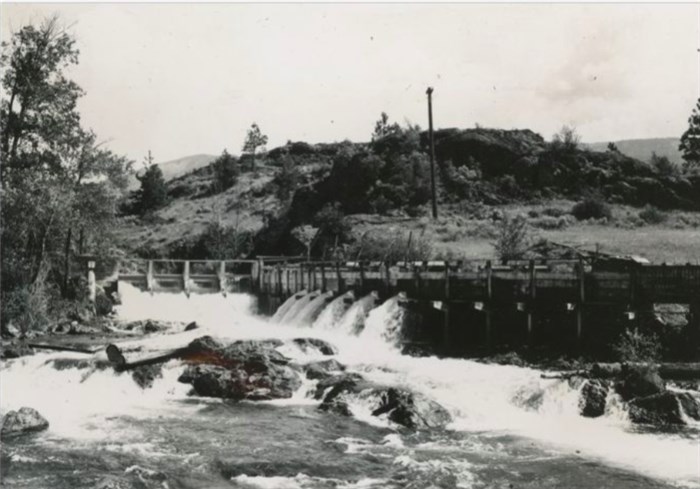
In Penticton, along with pictures of people enjoying the beach and historical buildings, was this one of the dam controlling the flow into Okanagan River.
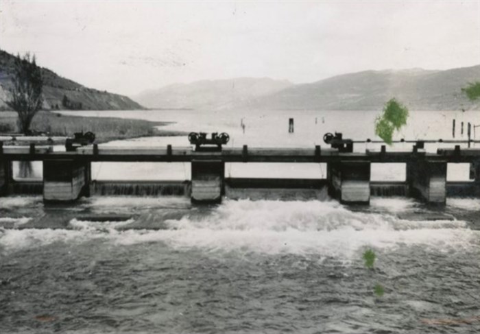
Penticton headgates.
Image Credit: Submitted/Enderby and District Museum
“The level of Okanagan Lake is regulated here and the supply of irrigation water for the country to the south is controlled,” he noted.
There is even this photo of the time when there was an actual waterfall at Okanagan Falls.
The falls at Okanagan Falls.
Image Credit: Submitted/Enderby and District Museum
"The settlement of Okanagan Falls stands at the south end of Skaha Lake," Burnett wrote. "Here the Okanagan River continues its course after passing through the lake. Near the falls we ran across two young fellows who had located a bench high above the river and were planning to install a pumping plant.
"There are many hundreds of acres, perhaps thousands of acres, on both sides of Okanagan Valley that will eventually be settled up when cheap power is available for pumping water from the lakes and rivers. Most of the land that can be watered by gravity systems is now under cultivation. There are many who prefer to live in a drier and warmer climate. Even at the Coast there are sometimes periods during the summer months when water would benefit the crops.
"Adams Lake as a source of power has been ruled out in favour of the spawning salmon. Perhaps some day the Columbia above Revelstoke will be harnessed for power production."
READ MORE: How a South Okanagan town got its name from a waterfall that no longer exists
Further south, he’s inserted a 1910 photo, attributed to C.B. Bailey, of McIntyre Bluff overlooking Vaseux Lake,
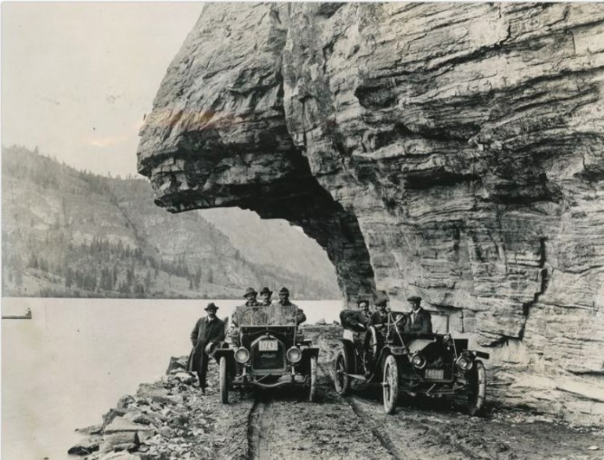
The McIntyre Bluff at Vaseux Lake.
Image Credit: Submitted/Enderby and District Museum
“Vasseau (sic) is said to mean ‘muddy slough’ being so named by a former French surveyor,” Burnett wrote. “That is decidedly a misnomer as far as the whole lake is concerned. Even at the north end where the river enters through a wide marshy flat, covered with aquatic plants, the name is hardly appropriate.
“This lake and the surrounding foreshore, through the consent and cooperation of nearby landowners, has become a bird sanctuary. It is probable that the Trumpeter and Whistling Swans once nested here. Now they are rare visitors.”
The 199-page album ends with the story of a crossing into the U.S. and back at Osoyoos.
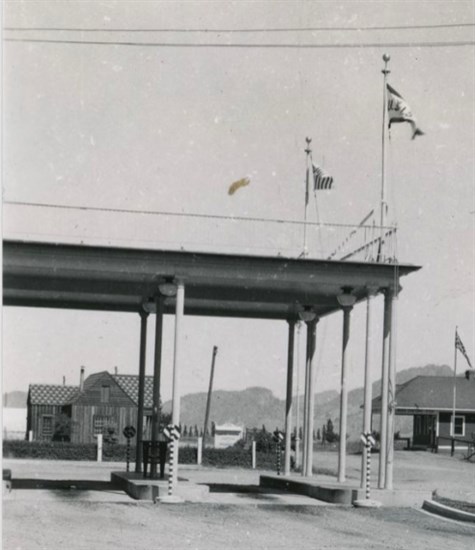
The Canada-U.S. border crossing at Osoyoos.
Image Credit: Submitted/Enderby and District Museum
“A row of concrete pillars marks the boundary line,” Burnett wrote. “On one of our visits to Oroville we had on board a dozen lemons. It was hot and we figured it was going to get hotter the further south we went. But, did we have lemonade? We did not, but someone else did. Our lemons were confiscated at the border because they were not stamped with the place of origin so Uncle Sam had lemonade at our expense.
“Near Oroville, we entered an apricot orchard and were told we could pick an apple box full for 25 cents. On the way back, at the Canadian Customs, we scooped out a generous two handfuls of ‘cots’ and were told to: ‘Pass friend, all’s well,’ although our fruit was not stamped.
“However, it is a long time since the Boston Tea Party and such incidents are unlikely to hinder the erection of a Peace Arch at this point.”
"B.C.'s Inland Empire" can be viewed on the B.C. Regional Digitized History website here.
To contact a reporter for this story, email Rob Munro or call 250-808-0143 or email the editor. You can also submit photos, videos or news tips to the newsroom and be entered to win a monthly prize draw.
We welcome your comments and opinions on our stories but play nice. We won't censor or delete comments unless they contain off-topic statements or links, unnecessary vulgarity, false facts, spam or obviously fake profiles. If you have any concerns about what you see in comments, email the editor in the link above.
News from © iNFOnews, 2023