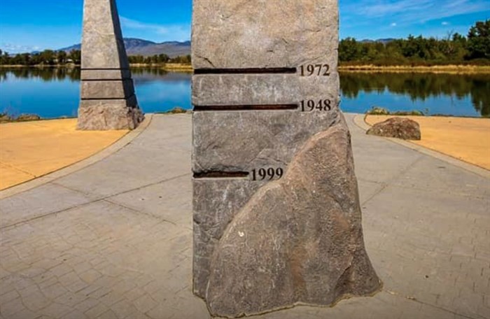
These flood markers at Riverside Park show the water levels of some of the historical floods in Kamloops.
Image Credit: SUBMITTED / Wayne Parsons Photography
June 03, 2020 - 7:30 AM
As the City of Kamloops prepares to deal with rising river levels, it might be worth it to take a look back at one of the most destructive floods that happened in the River City.
Sylvia Gropp was an archivist at the Kamloops Museum and Archives and helped to write the book ‘Kamloops: Trading Post to Tournament Capital.’ One of her focus areas is what she calls the most destructive flood in Kamloops history, the flood of 1948.
The flood began when a natural dam at Devick Lake burst May 25, 1948, sending a wall of water rushing towards Heffley Creek residents at around 3 a.m.
“It sent about a 30-foot wall of water rushing down Heffley. It was so loud that they say a lot of the residents of Heffley could actually hear the water coming and woke up and could get out of its path,” Gropp says. "It was a huge amount of water that we were dealing with.”
Gropp says homes were destroyed and livestock were killed, although there were no reported deaths from the early-morning emergency and the following flood.
The days that followed continued to pose problems for homeowners in multiple areas of Kamloops and affected other townships on the Thompson River. Gropp says although the water level noted at markers in Riverside Park shows the 1948 flood has lower water levels than the 1972 flood and the 1894 flood, the flood of 1948 was more destructive because there was more residents than in 1894, and they were unprepared.
“In 1948, this was pre-dyke. Even though we've had bigger floods and people go to Riverside Park and see that (1894) flood marker, they're like, ‘Holy cow that must've been so destructive.’ It wasn't, because we didn't have the infrastructure and we didn't have the population that we did in 1948.”
The efforts to keep homes safe brought out more than 500 volunteers who sandbagged and some who took in displaced people. The residents weren’t out of the water for weeks, as the flood crested on June 9. From there, Gropp says many other communities along the river were affected as the weather warmed and water flowed.
“From Chilliwack to Richmond, there were 2,300 homes destroyed and 15,000 people forced to evacuate... it was just a perfect storm that year,” Gropp says. “This was a snowball effect. It came down the North Thompson, it affected the Thompson and South Thompson, and you can almost find the dominos as they go, like as the Thompson hits the Fraser… you can see what happens in Abbotsford and everything as this water is making its way through all the river system.”
Gropp says this flood changed things for Kamloops, and the efforts afterwards have left a mark on the River City.
“After that flood, that was the real sit down, 'we need to do something', and that’s why we really have such an extensive dyke system now.”
This video shared by the Kamloops Museum and Archives states that more than 15,000 square yards of dirt were moved to create the dyke system we now have in place. Check it out below.
Credit: YOUTUBE / Kamloops Museum and Archives
To contact a reporter for this story, email Jenna Wheeler or call (250) 819-6089 or email the editor. You can also submit photos, videos or news tips to the newsroom and be entered to win a monthly prize draw.
We welcome your comments and opinions on our stories but play nice. We won't censor or delete comments unless they contain off-topic statements or links, unnecessary vulgarity, false facts, spam or obviously fake profiles. If you have any concerns about what you see in comments, email the editor in the link above.
News from © iNFOnews, 2020