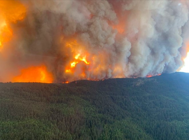
The Kookipi Creek Wildfire forced the closure of Highway 1 in the Fraser Canyon overnight.
Image Credit: Facebook/BC Wildfire Service
September 08, 2023 - 7:00 PM
A UBC Okanagan researcher has teamed up with a telecommunications company to develop a new technology to help predict and prevent future wildfire devastation.
In collaboration with Rodgers Communications, assistant professor Mathieu Bourbonnais is working on a two-year-long project to bring cheaper and more efficient weather stations to the Okanagan.
The technology uses a system called the Internet of Things. Sensors are dotted across the Okanagan region to continuously monitor and collect data on weather conditions including things like temperature, precipitation, relative humidity, wind speed, wind direction, soil moisture and soil temperature.
“The whole point is to kind of give ourselves a better understanding of where there's the most risk on the landscape, and if we have a fire, what that fire might do,” Bourbonnais said.
The current procedure for collecting this kind of data relies on expensive and limited weather stations. There are only around 250 weather stations in BC providing the information for the fire risk map for the entire province.
Bourbonnais’ equipment, he said, creates a low-cost network of weather stations that use cellular signal to communicate the data they collect. This means the sensors can be put anywhere in the forest with a cellular connection and more of them can be produced because they are so cost efficient.
“That data is sent back to us then, in almost real time, to a system that we've set up at UBCO,” Bourbonnais said. “We’re working on right now, an artificial intelligence approach where it takes this data from these sensors and it takes data that we've collected in the field.”
Bourbonnais said his team is also out in the field hand-collecting fire fuel samples.
“We go out and we actually collect like twigs and branches and grasses and other kinds of things, and we come back, and we bring them back to the lab and we actually measure how much moisture there is in that fuel,” he said.
“What the system is evolving to is a system where we can monitor, with tons of these sensors, what's actually happening in our forests in real time," he said. "And then our model will actually predict, based on those conditions, what we might expect for fire risk, and if we get a fire, eventually what we might expect for fire behaviour.”
Bourbonnais said he's hoping they'll be able to connect the sensors to a satellite signal in the near future. The technology could then be set up anywhere in the province, resulting in a more detailed map of high risk fire zones.
“[When] we understand from the system, consistently we're seeing higher risk in those areas, those might be cues to go do mitigation,” he said. “[We can] thin that forest using harvesting techniques where we pull out some of the trees, and then using things like prescribed fire or cultural fire to reduce fuel loads.”
Bourbonnais explained that, for a variety of reasons, there's been an increase in fire fuel on the forests floor that has contributed to more severe fires across the province.
"So, generally, what we've seen over the last 100 years-ish with kind of fire suppression [and] just how we manage landscapes is, in a lot of areas, we have way more fuel that's available to burn than we used to,” Bourbonnais said.
He said wildfire burns are often inconsistent in terms of severity.
“You have areas where it'll burn really, really hot and it'll burn everything, the trees from the crown all the way to the ground, even down into the mineral soils or through like kind of all the organic matter,” he said. “But then you'll have other areas where fires only burn through the ground or it just isn't as severe and those kind of areas will rebound quicker, recover faster.”
The approach to mitigation therefore must be specific to the region.
“It’s never just the fuels themselves, it’s the weather, it’s the topography,” he said.
“So, when we're looking at fuel mitigation, if we're specifically looking at reducing fuel loads, if we were developing a prescription plan for that forest, we would go in and say, 'OK, we're going to remove trees to try to space them out more.' We might try to remove some of the understory so that it isn't continuous from the ground to the crown, and those kind of things.”
From the data collected by the sensors and prescribed fuel mitigation plans, Bourbonnais hopes to help decrease the number of out of control fires, like the McDougall Creek wildfire, happening in the province.
“I think if you look at these fire events that are happening, there always seems to be an element of surprise,” Bourbonnais said. “I think now with where technology is going… we can probably help with that a little bit, with these kinds of systems.”
To contact a reporter for this story, email Georgina Whitehouse or call 250-864-7494 or email the editor. You can also submit photos, videos or news tips to the newsroom and be entered to win a monthly prize draw.
We welcome your comments and opinions on our stories but play nice. We won't censor or delete comments unless they contain off-topic statements or links, unnecessary vulgarity, false facts, spam or obviously fake profiles. If you have any concerns about what you see in comments, email the editor in the link above. SUBSCRIBE to our awesome newsletter here.
News from © iNFOnews, 2023