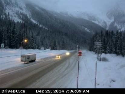
As much as 25 cm could fall at Rogers Pass over the next 24 hours.
Image Credit: Drive B.C. webcam
December 23, 2014 - 9:58 AM
THOMPSON-OKANAGAN - If you have travel plans over the next couple of days give yourself a little more time, and not just because of the amount of holiday traffic that usually files down the highway at this time of year. The next 24 hours could bring a lot of snow as well.
Environment Canada is warning a frontal system moving over the Interior could bring significant snow accumulations of 15 to 25 centimetres to Rogers Pass on Highway 1, Pine Pass on Highway 97 and Kootenay Pass on Highway 3.
Snow will begin early this morning over Pine Pass and Rogers Pass and will spread south later in the morning. The heaviest snow will likely occur this afternoon and tonight.
There is nearly 70 cm of snow on the ground at Albert Canyon between Eagle Pass and Rogers Pass and another 20 to 25 cm is expected today at Rogers Pass. Rain at the Coquihalla Summit will change to snow late in the evening, with 5 to 10 cm forecast. The Okanagan Connector is also expected to see 2 to 4 cm of snow by this afternoon.
In Penticton and Kelowna there is a chance of both snow and rain today while Vernon could have snow in the morning and wet snow in the afternoon. There is a 30 per cent chance of flurries in Kamloops this morning. There is also a chance of flurries or rain Wednesday while Christmas Day is forecast to be dry and just above seasonal normals of -1 Celsius.
To contact a reporter for this story, email Jennifer Stahn at jstahn@infonews.ca or call 250-819-3723. To contact an editor, email mjones@infonews.ca or call 250-718-2724.
News from © iNFOnews, 2014