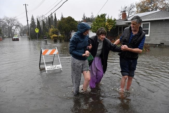
Nurse Katie Leonard, left, assists Scott Mathers, right, as they rescue Mathers' mother, Patsy Costello, 88, after being trapped in her vehicle for over an hour on Astrid Drive in Pleasant Hill, Calif., on Saturday, Dec. 31, 2022. Costello drove her car on the flooded street thinking she could make it when it stalled in the two feet of water. After two hours the water had receded about a foot making it easier to rescue her. Police were called but stood by and watched after calling in a tow truck to help pull the car out of the water. Nurse Katie Leonard, of Pleasant Hill, lives down the block used her kayak to bring Costello hot tea, blankets, food and a phone to call a friend.
Image Credit: ASSOCIATED PRESS/Jose Carlos Fajardo
January 01, 2023 - 4:30 PM
Evacuation warnings were in place in rural Northern California on New Year's Day after a powerful storm brought drenching rain or heavy snowfall to much of the state, breaching levees, snarling traffic and closing major highways.
Major flooding occurred in agricultural areas about 20 miles (32 kilometers) south of Sacramento, where rivers swelled beyond their banks and inundated dozens of cars along State Route 99. Emergency crews rescued motorists on New Year's Eve into Sunday morning and the highway remained closed.
Residents of the low-lying communities of Point Pleasant, Glanville Tract and Franklin Pond near Interstate 5 were told to prepare to leave before more roadways are cut off by rising water and evacuation becomes impossible.
“It is expected that the flooding from the Cosumnes River and the Mokelumne River is moving southwest toward I-5 and could reach these areas in the middle of the night,” the Sacramento County Office of Emergency Services said on Twitter Sunday afternoon. “Livestock in the affected areas should be moved to higher ground.”
To the north in the state’s capital, crews cleared downed trees from roads and sidewalks as at least 33,000 customers were still without power Sunday, down from more than 150,000 a day earlier, according to a Sacramento Municipal Utility District online map.
Near Lake Tahoe, dozens of drivers were rescued on New Year's Eve along Interstate 80 after cars spun out in the snow during the blizzard, the California Department of Transportation said. The key route to the mountains from the San Francisco Bay Area reopened early Sunday to passenger vehicles with chains.
“The roads are extremely slick so let’s all work together and slow down so we can keep I-80 open,” the California Highway Patrol said on Twitter. Several other highways, including State Route 50, also reopened.
More than 4 feet (1.2 meters) of snow had accumulated in the high Sierra Nevada, and the Mammoth Mountain Ski Area said heavy, wet snow would cause major delays in chairlift openings. On Saturday, the resort reported numerous lift closings, citing high winds, low visibility and ice.
A so-called atmospheric river storm pulled in a long and wide plume of moisture from the Pacific Ocean. Flooding and rock slides closed portions of roads across the state.
Rainfall in downtown San Francisco hit 5.46 inches (13.87 cm) on New Year's Eve, making it the second-wettest day on record, behind a November 1994 deluge, the National Weather Service said. Videos on Twitter showed mud-colored water streaming along San Francisco streets, and a staircase in Oakland turned into a veritable waterfall by heavy rains.
In Southern California, several people were rescued after floodwaters inundated cars in San Bernardino and Orange counties. No major injuries were reported.
With the region drying out on New Year’s Day and no rainfall expected during Monday’s Rose Parade in Pasadena, spectators began staking out their spots for the annual floral spectacle.
The rain was welcomed in drought-parched California. The past three years have been the state's driest on record — but much more precipitation is needed to make a significant difference.
It was the first of several storms expected to roll across the state in the span of a week. Saturday's system was warmer and wetter, while storms this week will be colder, said Hannah Chandler-Cooley, a meteorologist at the National Weather Service in Sacramento.
The Sacramento region could receive a total of 4 to 5 inches (10 to 13 centimeters) of rain over the week, Chandler-Cooley said.
Another round of heavy showers was also forecast for Southern California on Tuesday or Wednesday, the National Weather Service's Los Angeles-area office said.
News from © The Associated Press, 2023