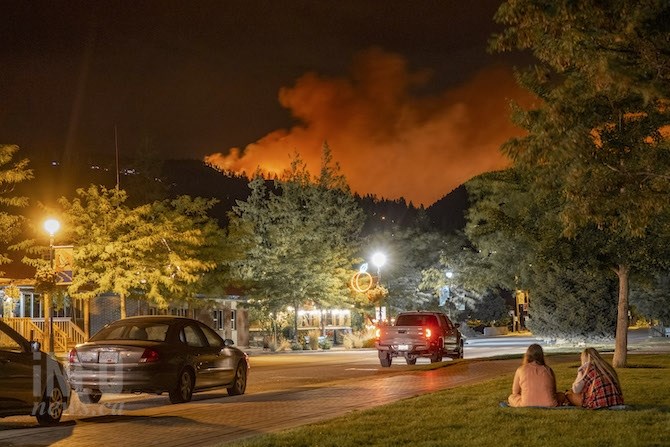
Mt.Law wildfire from Peachland, Aug. 15.
(DAN WALTON / iNFOnews.ca)
Republished August 17, 2021 - 4:52 PM
Original Publication Date August 17, 2021 - 8:37 AM
Fire officials were able to get into an area along Westside Road today to evaluate the damage caused overnight Sunday by the White Rock Lake wildfire.
The news wasn’t good.
“In spite of the heroic efforts of our North Westside Fire Department, BC Wildfire Service and other partners, the blaze took about 70 structures,” Gail Given, chair of the Regional District of Central Okanagan regional district said in a news release today, Aug. 17. “With over 1,463 properties evacuated, I am grateful that no lives have been lost and that the dedicated crews managed to protect so many other structures.”
While the release doesn’t identify what areas were hardest hit, it did acknowledge that “this has been an extraordinarily tough day for many residents who live in the neighbourhoods of the North Westside including Killiney Beach, Estamont, Aspen Shores, Summersands, Attenborough Road and Ewings Landing.”
“This has been one of the saddest days we’ve faced together in our community,” Wayne Carson, the regional district director for that area said in the release. He is one of the evacuees as his home is in Killiny Beach.
“I’ve talked with many of the residents who got the news today," he said. "They are figuring out next steps. We’ll be here to help and we hope, as they move forward in the days and weeks ahead, that their family and friends will be there to support them too.”
Fire officials now say that at least 70 structures in the Killiny Beach and Ewings Landing area on the west side of Okanagan Lake have been significantly damaged by the White Rock Lake wildfire.
An earlier estimate was that 50 to 60 structures were damaged.
There is still too much fire activity in the area to allow residents in.
READ MORE: UPDATE: Significant structure damage caused by wildfires in Central Okanagan
“It is taking us longer than anticipated to confirm properties and owner contact information for the impacted area,” Brian Reardon, director of Central Okanagan Emergency Operations said in a news release. “Given the gravity of this news for home owners we are being diligent in confirming these identities.”
Homeowners, even those who don’t live in those areas, are asked to register with emergency social services online at ess.gov.bc.ca.
Officials plan to start calling property owners today saying once it is safe for further assessments it's possible more properties with significant damage could be discovered.
The affected properties lie along Westside Road north of Fintry and West Kelowna.
More information and a map of properties under evacuation order and alert can be seen here.
A map of the White Rock Lake fire can be seen here.
B.C. Wildfire officials say that the White Rock Lake fire was active on all fronts yesterday.
“New guard lines have been identified and construction has begun on the northeast flank,” states a statement on the B.C. Wildfire website posted at 9:43 p.m. yesterday. “On the southwest flank, heavy equipment operators are constructing a guard line and crews are actively mopping-up. Increased fire activity was observed along the whole southern perimeter of the wildfire last evening.
“On the northwest flank, west of Falkland, a recently completed planned ignition helped to hold the wildfire and officers found little growth experienced in that area. The most significant growth was in the northeast, from Naswhito Creek across Six Mile Creek, and on the east flank down into Okanagan Indian Band IR#1 and across Westside road in the Fintry Park/Ewing area," the wildfire service update said.
Further south, 18 more properties in Peachland and the Central Okanagan Regional District have been put on evacuation alert due to the Mt. Law wildfire burning near the West Kelowna neighbourhood of Glenrosa and the Okanagan Connector.
Properties added to the existing alert include:
-
4850 to 4855 MacKinnon Road
-
4802 to 4995 Trepanier Road
-
4902 to 4975 Star Place
The cooler temperatures and some light rain overnight provided some relief for fire crews on the Mt. Law wildfire but the emergency operations centre said conditions remain extremely dry and the blaze is still active and classified as out of control.
“There are currently 44 personnel in the area today. Our focus includes putting out hot spots, continuing patrols and completing damage assessments when it’s safe to do so,” West Kelowna fire chief Jason Brolund said in a media release. “It’s critical for the safety of our crews and suppression efforts that all residents leave and stay out of evacuated areas.”
For more information on evacuation orders, alerts and maps due to the Mt. Law fire, go here.
There has been no update on this fire posted on the B.C. Wildfire website since 11:15 a.m. yesterday.
For a map of the Mt. Law fire, go here.
— This story was updated at 12 p.m. Tuesday, Aug. 17, 2021 to include more information about the Mt. Law wildfire.
-—This story was updated at 4:30 p.m., Tuesday, Aug. 17, 2021 to include new information.
To contact a reporter for this story, email Rob Munro or call 250-808-0143 or email the editor. You can also submit photos, videos or news tips to the newsroom and be entered to win a monthly prize draw.
We welcome your comments and opinions on our stories but play nice. We won't censor or delete comments unless they contain off-topic statements or links, unnecessary vulgarity, false facts, spam or obviously fake profiles. If you have any concerns about what you see in comments, email the editor in the link above.
News from © iNFOnews, 2021