
Flooding off Westside Road on Okanagan Lake in 2017.
(CHARLOTTE HELSTON / iNFOnews.ca)
March 15, 2021 - 6:00 AM
Every year Shaun Reimer fights an increasingly difficult battle to find the perfect balance between Okanagan Lake flooding or falling into drought mode.
But it’s likely to take at least five years before the Ministry of Forest’s section head for public safety in the Okanagan stands a chance of getting any significant help.
That’s because it’s expected to take that long for the Okanagan Basin Water Board and the province to do all the studies needed just to get a plan of action in place, part of which will be a review of what’s considered the “correct” full pool level for Okanagan Lake.
That means serious flooding that hit the Valley in 2017 and 2018 may happen again, despite Reimer’s best efforts.
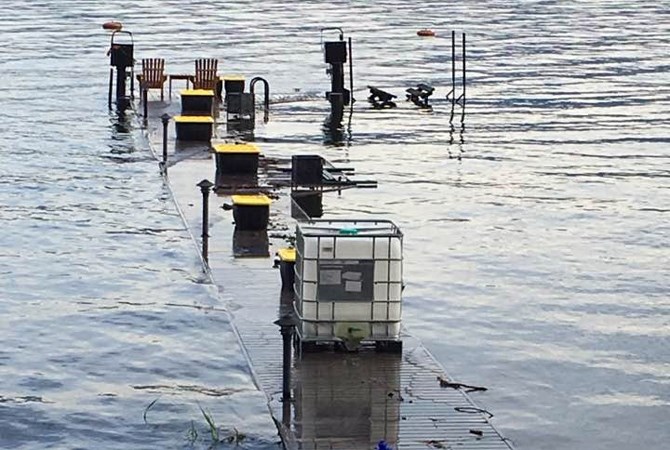
Docks across the Central Okanagan were under water.
Image Credit: Contributed/Rose Sexsmith
“Our infrastructure was never built to react to high inflows,” Reimer told the water board during its October 2020 board meeting. “We know we have to make changes.”
That was in response to concerns raised by the District of Peachland council in the summer of 2020 about how the lake level is set each spring.
Reimer is not supposed to allow the lake to get above 342.75 metres above sea level. But, in 2017 and 2018, unexpected weather conditions raised the lake above that mark and caused extensive flooding.
Given that climate change has made the spring freshet very unpredictable and the limitations on how much water can be released from the Penticton dam, such floods can easily happen again.
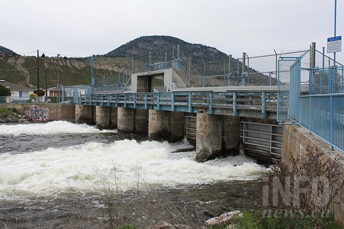
Water flow through Okanagan Lake dam on May 7, 2017.
(STEVE ARSTAD / iNFOnews.ca)
In 2017, the Okanagan Lake level climbed by 30 cm a week for five weeks. Reimer could only release 12 cm a week in order to prevent extensive flooding downstream.
The concerns raised by Peachland culminated in the water board sending a letter to the province last week insisting it get on board, including with significant funding, for five year’s worth of studies to determine how best to change the way Okanagan Lake is managed.
READ MORE: Time for B.C. government to get serious about Okanagan Lake flooding: OBWB
“They (provincial government) should be prioritizing the Okanagan in their budget,” Anna Warwick Sears, the executive director of the water board, told iNFOnews.ca. “The Okanagan really is an important economic driver in B.C. and we’re really at increasing risk here.”
It will not be an easy task arriving at the correct answers, Reimer said.
The 342.75 metre maximum target was set in the 1970s and followed years of consultation and often heated debate, he said.
Essentially, those in the north wanted the lake level to be lower to avoid flooding but those downstream from Penticton wanted it higher to ensure they had enough irrigation and drinking water later in the summers.
“This is about way more than just the lake level,” Warwick Sears said. “It’s a different way of thinking of the lake operations than we have in the past.”
While flooding is a big and immediate concern, all the forecasting shows there is a real risk of serious droughts that must be taken into account as well.
“Climate change is the big thing,” Warwick said. “The freshet will come earlier. We’ll have more precipitation and an increasing proportion of it will come as rain. There will be increasing winter inflows into the lake and reduced late summer inflows.”
That leaves a risk of flooding in the spring but, if the lake is lowered too much and those spring rains don’t fall, the Valley could be hit by drought.
Already the discussion has caused some pushback from the Peachland Watershed Protection Alliance.
“(The board’s media release) seems to suggest that the OBWB (Okanagan Basin Water Board) has lost confidence in the ‘control nature’ worldview and is now advocating a ‘work with nature’ worldview in the floodplain of the Okanagan Valley,” it said in a news release. “More frequent, longer, and more severe flooding, extreme run-off, boil water advisories and ensuing droughts have all been attributed to clear-cuts.”
The water board is well aware not only of the impact of logging on water flows but also of forest fires, roads and development, Warwick countered.
Current studies have shown what those impacts are under existing conditions. More study has to be done on the impact of future logging and other activities on flood risks, she said.
That’s likely to be part of the many studies that will have to be done in the coming years.
Other studies will look at the economic impact of things like floods and drought, she said.
“Do we dig a giant channel down to the Columbia River or do we set back some of the dikes and give more capacity for water?” Warwick Sears said. “There are a bunch of different things that need to be considered.”
The water board has developed a flood mapping system that identifies areas at risk of flooding but that focused on Okanagan Lake.
The International Joint Commission has been looking at the Similkameen River and its influence on Osoyoos Lake, so those studies have to integrate.
The Penticton dam will need to be rebuilt at some point so engineers need to look at how that might be done, along with ways to improve downstream flows.
There have been suggestions of increasing storage capacity in upper elevation lakes and reservoirs but the ability to do that is limited.
“Building reservoirs upstream is not going to solve the flooding issues on Okanagan Lake,” Warwick Sears said. “We’re talking about such an incredibly large amount of water.”
There has been talk about a dam and reservoir being built on Mission Creek, which accounts for 30 per cent of the water flowing into Okanagan Lake.
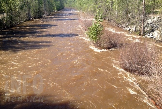
Mission Creek in Kelowna.
(ADAM PROSKIW / iNFOnews.ca)
“Say you build a giant new dam on upper Mission Creek for the purpose of holding up floodwaters,” Warwick Sears said. “You’re looking at putting a dam right above a very dense population center. So, if the dam filled faster than expected or there was any risk of catastrophic dam failure, then it would have a big impact sitting up there.”
A “gap analysis” will be released in April showing the full extent of the work that needs to be done in order to make recommendations not only on flood control but also dealing with the real risk of droughts.
Those will take years to complete but Warwick Sears wants to keep the pressure on the provincial government to make it happen.
“It’s clearly the province’s responsibility to operate the dam and manage it for flooding,” she said. “We just want to keep the focus on it and keep the momentum going. We just want the work to be done and done right.”
To contact a reporter for this story, email Rob Munro or call 250-808-0143 or email the editor. You can also submit photos, videos or news tips to the newsroom and be entered to win a monthly prize draw.
We welcome your comments and opinions on our stories but play nice. We won't censor or delete comments unless they contain off-topic statements or links, unnecessary vulgarity, false facts, spam or obviously fake profiles. If you have any concerns about what you see in comments, email the editor in the link above.
News from © iNFOnews, 2021