
iN VIDEO: Here’s a unique view of road travel through the Okanagan in 1966
If you want a glimpse at just how much the Okanagan has changed in the last 60 years, have a look at this video from the Ministry of Transportation.
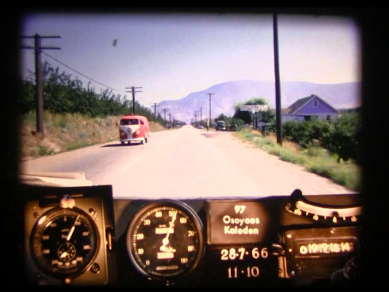
It's video a drive from the border to Vernon, in 1966 captured by thousands, if not millions, of photos taken from a Ministry of Transportation car.
READ MORE: iN PHOTOS: Treasure trove of historical depictions of life from Kamloops to Osoyoos
It’s something the ministry calls its Photolog.
“Before services like Google Street View, it was the way for ministry staff to take a virtual highway tour,” the ministry says on its website. “It was an indispensable tool to help manage our rehabilitation program and ensure we were fixing the roads that needed it the most.”
The technique creates a kineograph, more commonly known as a flip book, where the images are viewed in rapid succession to create the sense of movement.
“Every few years we send a vehicle on the road outfitted with a camera and special instruments,” the website says. “In addition to checking the road for smoothness, rutting, cracking, potholes and other issues, the camera is set up to automatically take a photo every 10 metres.”
The journey from the border to Vernon is more than 175 km and rated today, by Google, as a 2.5 hour drive. It’s such a long a journey that the ministry split the trip into three separate videos, running from 4.5 to 6.5 minutes each.
That’s at normal speed, which is so fast that trees and cliffs are barely identifiable as any kind of landmarks as they flash by. The images are not helped by the fact that the roadway is way over-exposed.
But, by going into settings, the speed can be dropped to one-quarter of normal or boosted to twice the normal speed.
That allows the viewer to enjoy the scenery and check out, for example, how the highway strip through Kelowna has changed over the last 57 years.
The ministry has a whole library of road trips that can be viewed here. It includes Highway 3 from Princeton to Osoyoos.
READ MORE: New time travel video shows Highway 3 from Princeton to Osoyoos in 1966
As to the future of flip books on B.C. highways?
“Even though we can now use any number of online services to see our roads, the Photolog is still an essential tool, because it combines a visual reference with a lot of other important data,” the ministry’s website says.
To contact a reporter for this story, email Rob Munro or call 250-808-0143 or email the editor. You can also submit photos, videos or news tips to the newsroom and be entered to win a monthly prize draw.
We welcome your comments and opinions on our stories but play nice. We won't censor or delete comments unless they contain off-topic statements or links, unnecessary vulgarity, false facts, spam or obviously fake profiles. If you have any concerns about what you see in comments, email the editor in the link above.