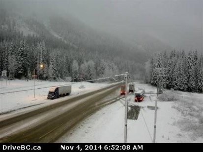
Image Credit: Drive B.C. webcam
November 04, 2014 - 10:27 AM
THOMPSON-OKANAGAN - If you needed proof winter is coming, you need not look further than Rogers Pass, where the snow is beginning to stick around.
Over the past day more than a centimetre has fallen in Albert Canyon between Glacier National Park and Mt. Revelstoke National Park, with even more falling at the higher elevations surrounding the valley.
Drive B.C. is reporting compact snow and slushy sections through Glacier National Park and limited visibility due to fog between the parks.
Rain is expected to end late this afternoon in the area and the snow level will fall to 1,000 metres again overnight.
On the Okanagan Connector the snow level will sit around 1,600 m today with isolated flurries in the morning while the southern portion of the Coquihalla Highway will see rain ending late this morning.
In town we can expect a 30-40 per cent chance of showers this morning with a mix of sun and cloud for the rest of the day along with temperatures reaching as high as 13 Celsius. In Kamloops that chance of rain will continue over the next two days while Vernon, Kelowna and Penticton can expect to receive rain Wednesday and Thursday. Seasonal normal high temperatures at this time of year are 6-7 C.
Ski hills around the region are also ramping up for the season. Snow began accumulating last week ahead of the planned Nov. 22-27 openings.
To contact a reporter for this story, email Jennifer Stahn at jstahn@infonews.ca or call 250-819-3723. To contact an editor, email mjones@infonews.ca or call 250-718-2724.
News from © iNFOnews, 2014