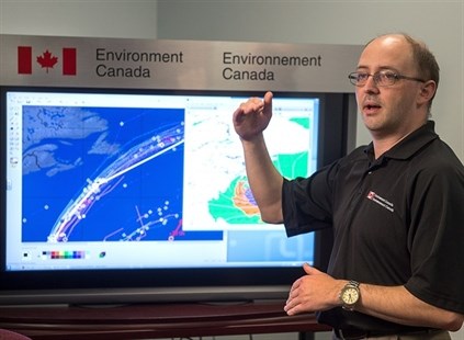
Chris Fogarty, a senior meteorologist at the Canadian Hurricane Centre, provides an update on Hurricane Gonzalo in Dartmouth on Friday, October 17, 2014. Fogarty said that there is a possibility of Gonzalo making landfall in the southeastern tip of Newfoundland and Labrador on Sunday morning.
Image Credit: THE CANADIAN PRESS/Andrew Vaughan
October 17, 2014 - 7:29 PM
ST. JOHN'S, N.L. - Newfoundlanders were told to prepare for another round of extreme weather as forecasters warned hurricane Gonzalo could cross the island's southeastern tip as a post-tropical storm overnight Saturday.
The Canadian Hurricane Centre said Friday there could be flooding on the Avalon Peninsula and storm surges in Cape Race and Trepassey if Gonzalo arrives at high tide early Sunday.
"It's a very fast-moving system," forecaster Chris Fogarty told a news conference in Halifax. "The heavy rain that they get in the Avalon Peninsula will be quite short-lived, but it could be very intense over a two- or three-hour period early Sunday and that could cause some flooding issues."
Up to 75 millimetres of rain could fall, Fogarty said.
In its latest forecast, the centre said there is about a 40 per cent chance of the storm making landfall. A complicating factor is a separate cold front not tied to hurricane Gonzalo that's expected to bring rain Saturday to Newfoundland.
Fogarty said Category 2-type winds between 154 and 177 kilometres per hour will likely roar over the Hibernia offshore oil platform, about 315 kilometres southeast of St. John's. Waves of 12 to 15 metres are also forecast in the Northern Grand Banks.
"We've been closely co-ordinating with the offshore oil sector ... talking with them about the details of these extreme winds that will occur there," he said.
Hibernia spokeswoman Margot Bruce O'Connell said Friday she does not expect production will be affected.
"We are taking all necessary precautions to ensure the safety of personnel," she said in an email. "The Hibernia platform is a gravity-based structure designed to withstand extreme weather conditions."
At least 700 people work offshore at Hibernia and on the Terra Nova and SeaRose floating production, storage and offloading vessels located slightly more east.
Husky Energy spokeswoman Colleen McConnell said Friday that she did not expect the SeaRose or its 90 workers would be affected. There are another 116 people on the GSF Grand Banks drill rig in the nearby North Amethyst field, she said.
"We are in the process of suspending the well that she's working on," McConnell said. "She will disconnect and stand by until the storm passes.
"We wouldn't want to stay connected to the well if there's going to be significant vessel motions."
McConnell also stressed that such equipment is designed to bear up under often ferocious North Atlantic weather.
Brian Murphy, a national union representative with Unifor, spent 10 years working on the Terra Nova. He can recall being out as the vessel rocked in 18-metre seas.
"It's very uncomfortable," he said in an interview. While Hibernia is a gravity-based structure that's like a stable island, the production ships move with the waves, he explained.
"You betcha," he said when asked if workers got seasick. But Murphy said medics are prepared to help and that severe weather is taken seriously.
The Atlantic coast of Nova Scotia can also expect high ocean swells, the hurricane centre said.
Hurricane Gonzalo slammed Bermuda with heavy surf and winds Friday as a Category 3 storm packing sustained winds of 185 kilometres per hour as it moved north-northeast.
Fogarty said while it's not clear how strong the winds will be over the Avalon Peninsula, it's very likely there will be strong waves hitting southeastern Newfoundland shores.
"Even if the heavy wind misses land completely, these waves and storm surge will still occur," he said.
"The timing will be critical. High tide is early around 5 a.m. on Sunday. If the storm arrives around that time there could be more flooding issues from surge and waves."
It's the latest extreme weather to hit the island in the last four years. The province has improved disaster prevention protocols since hurricane Igor wreaked $125 million in damages to eastern Newfoundland, cutting off 90 communities, 22 of which declared states of emergency.
Igor was followed by close calls as hurricane Maria and post-tropical storm Leslie in each of the next two years caused less damage than feared.
Judy Manning, the province's new emergency services minister, says she's confident the province is prepared.
"You can never anticipate every possible implication of a natural disaster," she said. "But in terms of how far we've progressed on that front, and the processes that are in place … I can certainly assure you that we're ready to respond to the best of our abilities."
Faith Warren, manager of the Dog House pet supply store in downtown St. John's, has lived in the city most of her life. She said she has seen first-hand what weather experts describe as a cyclical increase in recent Atlantic hurricane activity.
"It just seems we have a lot more wind," she said. "But we're pretty good. There's a lot worse going around in the world than what we get.
"I think we'll just hang tight and batten down the hatches."
—With files from Michael Tutton in Halifax.
LINK:
Canadian Hurricane Centre storm tracker
News from © The Canadian Press, 2014