
This is the aerial view of the accident site 33 kilometres west of Kelowna. It shows the likely flight path of Piper PA-30 before the initial tree strike.
Image Credit: Transportation Safety Board of Canada
November 27, 2013 - 11:57 AM
PENTICTON - Excess weight contributed to the crash of a Piper plane that departed Penticton Regional Airport on Aug. 13, 2012. Two out of the four people onboard were killed.
A Transportation Safety Board report released today stated too much weight, a reduced rate of climb and reduced power in the right engine were major factors leading Piper PA-30 into a ground collision near Brenda Mines 33 kilometres west of Kelowna.
The Piper left Penticton airport at 2:32 p.m. on a flight to Boundary Bay with one pilot and three passengers according to the report. The pilot filed a flight plan with the Kamloops flight information centre for the return trip. After takeoff the aircraft flew north over Okanagan Lake for about 37 km before turning west into a valley. This deviation was 26 km further than planned due to a "lower expected rate of climb." Aircraft wreckage was found about 2.5 hours later in a wooded area. One occupant died at the site while the other three were critically injured. One of those three died in hospital two days later.
Investigators determined the plane's flight path took it over a field of grass and then 61 metres of forest before it hit the first of five trees. The fuselage, the plane's body, was broken into three pieces.
Safety board officials concluded passenger safety could have been improved if the plane had shoulder harnesses as well as lap belts. The risk of a post-crash fire was reduced because the aircraft battery had disconnected during the collision removing a potential ignition source for the plane's fuel.
Following the accident Penticton airport had a sign installed advising pilots to climb to 5,000 feet or 1,524 metres before turning west or east when leaving the Okanagan Valley.
To contact a reporter for this story, to send photos or videos, email Shannon Quesnel at squesnel@infotelnews.ca, call 250-488-3065, send tweets to @shannonquesnel1 or @InfoNewsPentict.
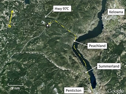
This map shows the probable route of Piper PA-30. The dashed/doubled dotted line shows the route up the lake to the accident site. The dashed line shows the published and filed route. The dotted line shows the low ground route connecting the published route and the probable one the pilot took.
Image Credit: Transportation Safety Board of Canada
News from © iNFOnews, 2013